Looking Up To See Down: Mesa de Anguila II
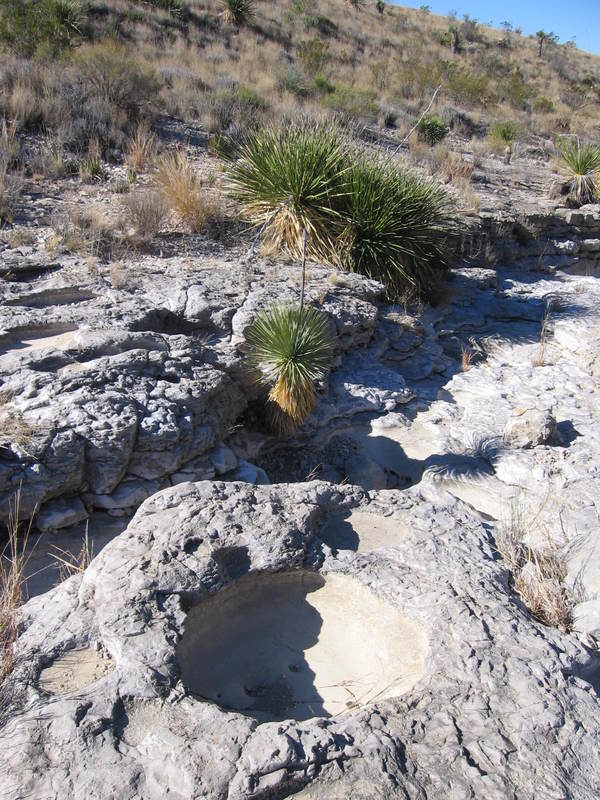
Our second day on the Mesa. We were heading for Tinaja Lujan. Tinajas are depressions that form along drainages, apparently due to concentrated erosion, and typically hold pools of water. As such, they are important resources for desert animals. Limestone is soluble in water, especially if the water is a bit acid. So, in nearly every drainage on the Santa Elena Limestone you cross on Mesa de Anguila you see cavities that may one day be tinajas. Sand and gravel trapped in the cavities accelerate the erosional process by eating into the rock as they are agitated by moving water during infrequent rains. Below you see a typical cavity and a possible future tinaja. (In truth, no one ever really shows "typical" subjects; note how nice, round, and photogenic this one is.)
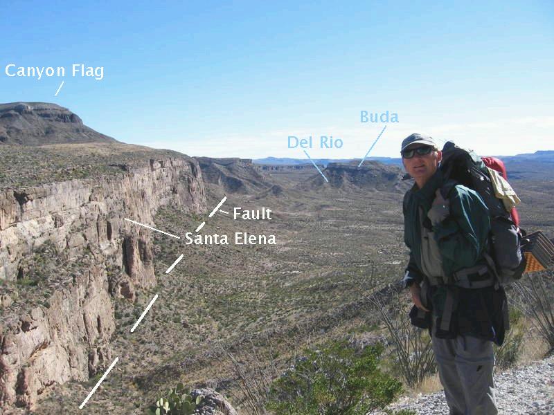
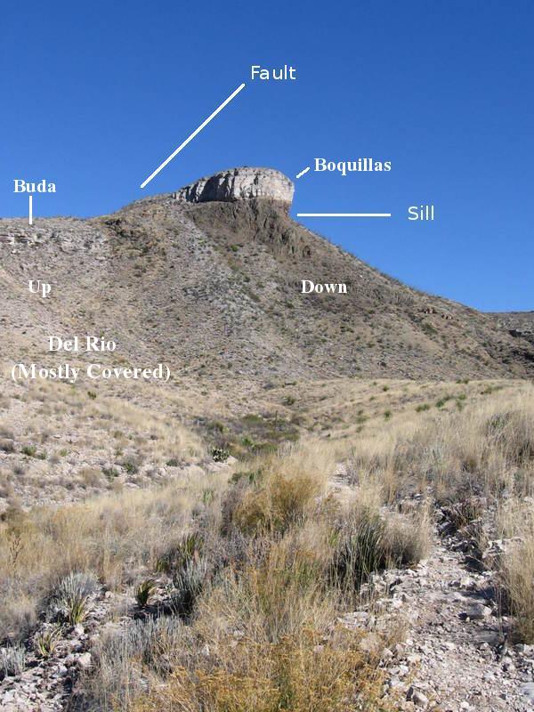
The following picture shows an impressive, nearly vertical Basin and Range fault scarp in the Santa Elena, extending from just northeast of Mariposa to the southeast. The mesita above the scarp on the left, Canyon Flag, has the upper Cretaceous Boquillas Formation on its summit, resting on an intrusive, igneous sill, which, in turn, is above the Buda Formation and the Del Rio Clay, also upper Cretaceous. The Canyon Flag rocks are well elevated above corresponding rocks on the mesitas to the right of the scarp due to the offset along the fault. (A mesita is a mesa resting on top of a larger mesa.) The scarp "floor" below Randy, as well as the scarp itself, is actually what constitutes the top of most of Mesa de Anguila and consists of lower Cretaceous Santa Elena Limestone. The mesitas on the right of the scarp are of Del Rio topped by Buda. Mesa de Anguila was created in its current form by faulting during the relatively recent Basin and Range activity, which appears to have lessened in the park to the point of disappearing over the last two million years. Note the mesas on top of mesas on top of mesas. Mesa de Anguila turned out to be an incredibly interesting geologic feature.
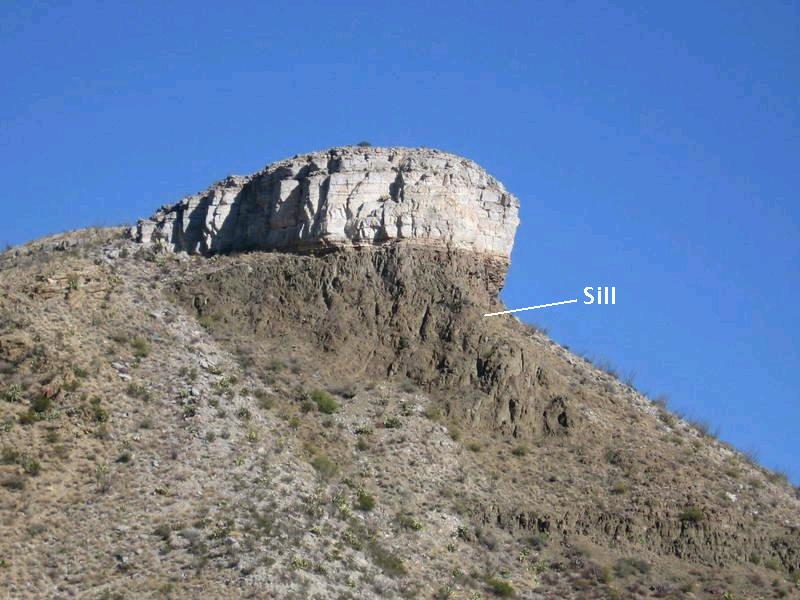
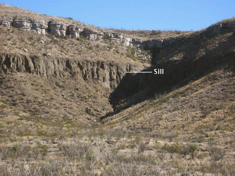
Everywhere you go on the Mesa - where the Boquillas Formation is exposed - you see the basaltic sill, mentioned above, that has intruded into this rock unit. A sill forms when magma seeps between two beds of rock and separates them, forming a layer of rock that looks as if it were simply part of the normal sequence of deposition, although it is younger than either the rock above or below it. (I don't know of an age for this sill other than it was intruded during the Tertiary period.) In the three pictures below, taken as we were heading toward a drainage gap in the mesitas, you see this igneous sill in the Boquillas, looking for all the world as if it were just part of the normal accumulation of rock with time. The first two images are of a ridge just west of Canyon Flag, a prominent mesita on the apex of Mesa de Anguila. The first is a close up of the sill beneath the Boquillas.
The second picture poses a puzzle. You can detect what appears to be an obvious fault as noted in the picture. The new USGS geological map of Big Bend, Scientific Investigations Map 3142, 2011, indicates Buda Limestone is on the left side of the fault and the throw is down to the left. However, that places the Buda topographically at the same level as the sill, which is presumably confined to the Boquillas. That creates a problem since the Buda is stratigraphically lower than the Boquillas, meaning the left side should be relatively up rather than down. Without further information I would have to say the fault is down on the right. Maybe a "typo" in the USGS map?
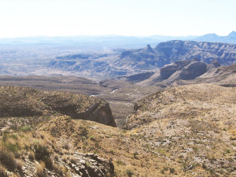
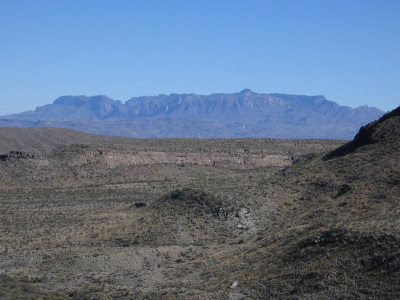
Mesas on mesas - descending to the Rio Grande. In the foreground of the next photo is a 400 foot drop (from 3360 to 2960 feet), followed by a 440 foot drop and then a more gradual descent to the river. These drops are due to northwest-southeast trending Basin and Range normal faults. This faulting began about 20 million years ago and extended from Nevada and southeastern California all the way to West Texas. In fact, the north face of Mesa de Anguila is due to the fault scarp of the Terlingua fault of Basin and Range age, which amounts to nearly 3000 feet of displacement at east end of Santa Elena Canyon. Mexico is in the distance, beyond the Rio Grande.
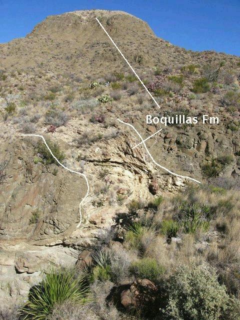
The trail to Tinaja Lujan passes just northwest of the mesita Canyon Flag, and follows a N-S-trending fault. I'm thinking the force of the intruding magma distorted the limestone of the Boquillas Formation exposed in this drainage and displayed in the following photo, which looks north toward Canyon Flag. Note the folding in the Boqillas beds, the contact between the Boquillas and the intrusive rock as indicated by the white lines, and the Boquillas atop the intrusive rock on the crest of the hill.
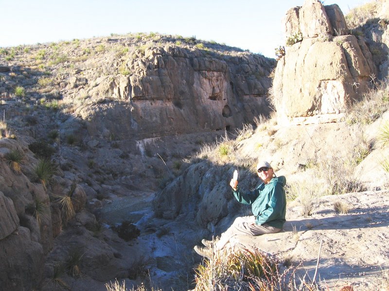
At last a place to camp. The picture below of Randy was taken at the entrance to the canyon that leads to Tinaja Lujan. Nothing like some sippin' spirits to top off a rough day of up-and-down hiking toting a heavy backpack.
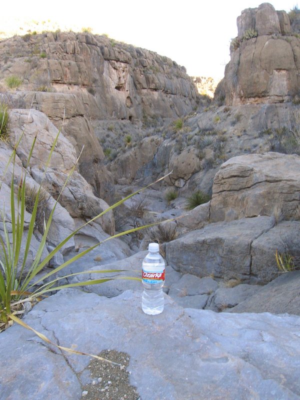
Speaking of liquid refreshment, we were told at park headquarters that we should find water at Tinaja Lujan. At first we were frustrated in that it seemed there was no water to be had anywhere. But our persistence finally paid off. As you can see in the following picture, there was indeed water at Tinaja Lujan. (Likely there was water at the actual tinaja, but we just didn't manage to make it there.)
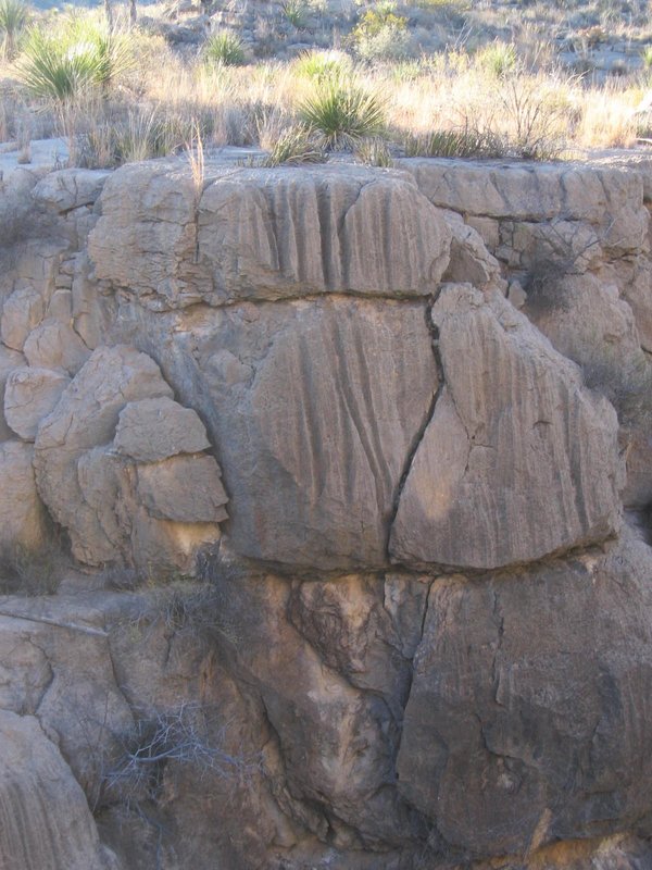
The effect of water on the Santa Elena Limestone in the area of the campsite was evident, however. Limestone is soluble in acidic water, and rainwater can contain carbonic acid due to the reaction between the water and carbon dioxide in the air. Water running down the face of the limestone can therefore produce curious grooves such as those in the photo below.
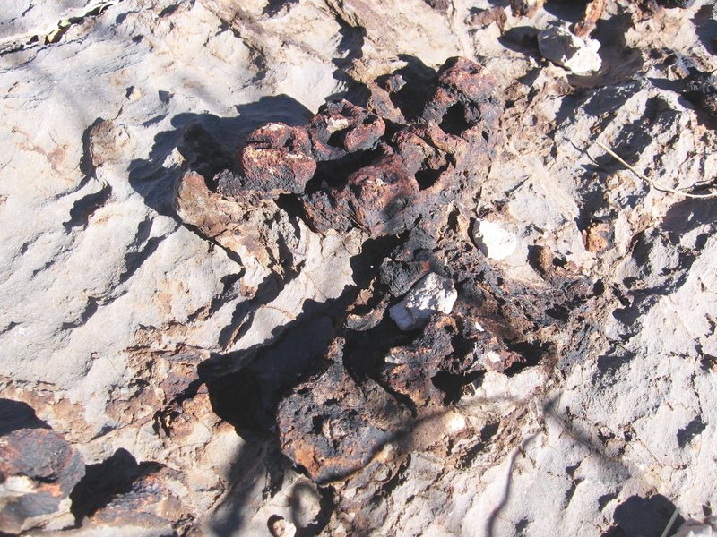
Above our campsite near Tinaja Lujan was a line of concretions (or, a "horizon" in geological terminology, meaning the line appears to be parallel to the bedding planes) in the Santa Elena limestone, seen in the image below. At our first campsite I had noticed that the ground was covered with small, black minerals, some of which were almost perfect cubes. At the time I recognized that the minerals must almost certainly be an iron oxide or hydroxide, but the square crystal habit (the shape a crystal naturally grows into) was puzzling. When I examined the concretions, I found they were composed of pyrite in various states of chemical decomposition.
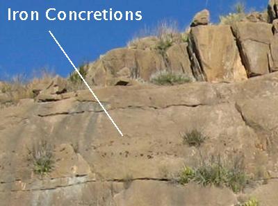
This made it clear what the black crystals found earlier were. They were mineral pseudomorphs - the result of one mineral replacing another yet maintaining the crystal habit of the original mineral. In this case I suspect the replacement mineral was an iron oxide called hematite or iron hydroxide called goethite. Since pyrite has a cubic crystalline structure, it often grows as cube-shaped crystals. Although neither hematite nor goethite is cubic, when the chemical reaction (involving the addition of oxygen and/or water) converts the pyrite to the replacement mineral, the original shape is maintained. And below is a close-up of some large concretions, showing advanced weathering. I think the pseulomorphs must have formed below the surface in order for the shape to be preserved.
It is not hard to make your way up to the top of the mesita overlooking Tinaja Lujan. (Not hard, that is, if you know which approach to use. Unfortunately for us, we didn't find the right approach upward until we were heading downward.) From there you get an expansive view of the western half of Big Bend National Park. To the northeast are the high Chisos Mountains, as seen in the following image, with Emory Peak rising above the crowd.
It is ironic to realize that you are standing on an uplifted block of the Earth's crust looking upward at a down-dropped block of the Earth's crust. The rocks that used to rest on the spot you are standing have been eroded away, but not as much erosion has occurred on the down-dropped block due to the resistance of that block's rock to erosion. Although Mesa de Anguila looks pretty trivial from the Chisos, due to both distance and elevation, up close it is a very impressive feature.
When you turn your gaze westward, you see the strange terrain shown in the following photo Originally, I thought these weird erosional patterns were incised meanders, but after further study and thought it appears some of the erosion may be due to the river but others due to tributary drainages and the series of parallel faults discussed below. I now believe there are no real incised meanders along the river in this area.
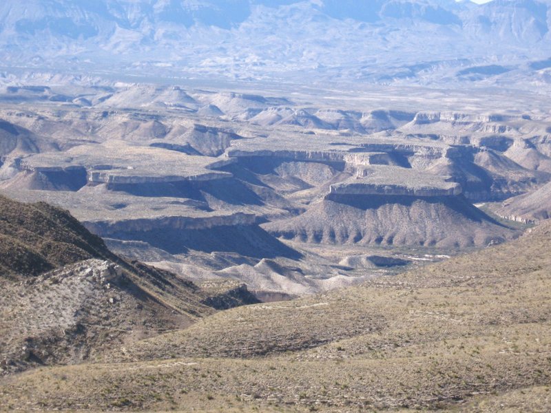
Examination of satellite images indicates that the rock below the resistant bed forming the top of the mesas on the other side of the river in the photo has a weathered appearance just like that of the igneous intrusion on Mesa de Anguila and therefore likely the extension of that into Mexico. That would make the resistant bed correlative to the Boquillas Formation. If you look closely, you can see resistant beds below the slopes, which are probably also Boquillas.
There is a series of northwest-southeast trending Basin-and-Range normal faults around the Mariposa on the USGS map where the southwest sides of the faults are generally down compared to the northeast sides, and one of these faults may be indicated in the photo. (Note the dipping beds to the left of the foreground drainage with nearly horizontal beds to the right.) There is a mesa to the west of Mariposa that lies southwest of one of these faults, topped with the Boquillas Formation, that is about at the same topographic level as the top of the mesas in the photo. This supports the identification above of the makeup of the mesas on the other side of the Rio Grande.
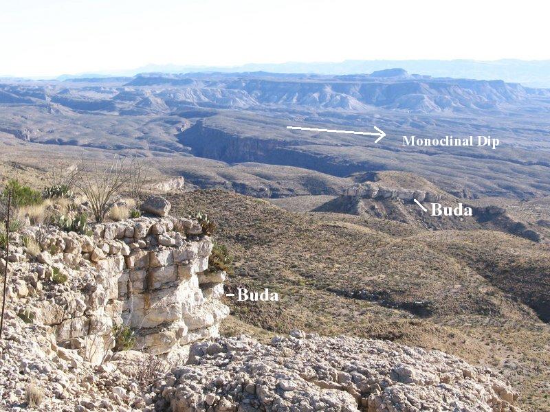
Finally, you turn to the east where you see how the Rio Grande has cut into the Cretaceous limestones to form Santa Elena Canyon. The river cut deepens to 1500 feet as you approach the eastern mouth of the canyon. Also note the Buda outcropping in the foreground and on a hilltop below, proof that the fault between here and there is down on the opposite side. As the top of the Santa Elena is an approximate bedding plane, it allows you to visualize the dip of the Mesa de Anguila monocline. After a day of incredible vistas and curious landforms, we reluctantly prepared to head off Mesa de Anguila the following day.
BACKWARD to Mesa de Anguila I
FORWARD to Mesa de Anguila III
ALL THE WAY BACK to the Contents