Original Introduction:
Apparently, the time you could cross the Rio Grande by boat for a couple of bucks and either walk or ride on a burro or mule up to the town of Boquillas del Carmen for a cerveza or two has passed – perhaps permanently. Chalk it up to the current fear gripping the country, shamefully exploited by our politicians, each one claiming to be tougher on terrorism than the next. No, siree. We ain't gonna allow old Osama Ben to enter the U.S. at Boquillas Crossing posing as a thirsty geologist. And don't even think about buying a gorgeous fluorite crystal or gaily decorated hiking stick snuck across the river by the citizens of Boquillas, who are trying to survive after the collapse of the tourist trade. That there's contraband, you know. (The Boquillastas will tell you the fluorite is amethyst, but at two dollars a crystal, it's still a bargain. Not that I would advise you to break the law and buy it, you understand.)
Some years ago, a project was begun to enable tourists to once again visit and shop in Boquillas del Carmen and to allow the unfortunate populace of the town to be able to come across the river to buy needed staples, rather than having to go a hundred miles to the nearest legal crossing (Presidio, TX). The population of the town had plummeted, due to lack of income and the needlessly imposed isolation. Even so, to placate those who are still afraid the ghost of Osama might cross there, the border guys installed some strict security. The vicious comments appended to the online news stories by right wingers who have never been to the area were ridiculous. According to their blatherings we could expect a flood of illegals crossing at Boquillas. Well, as I pointed out, there better be a bus service for them, because if they have to cross Big Bend by foot, we will have a flood of dead illegals lying across the park.
But even the anti-immigrant super patriots should be pleased with the new crossing. (Old Mad Magazine definition of a super patriot: "A person who loves his country while hating 90% of those who live in it.") You have to go through scrutiny by officials on both sides to cross, and you'll need your US passport to get into Mexico. This is a lot different from the old informal way crossings were allowed and no doubt still a burden on the citizens of Boquillas del Carmen. As a ranger pointed out, these citizens are our best defense against those crossing who could be threats. They would quickly recognize a suspicious person, and they would report it. It is in their interest, very much so, not to allow an incident to lead to a new closing of the border there.
The road to Boquillas Canyon is on the east side of the Chisos Mountains and roughly follows Tornillo Creek. Tornillo ("screw" in Spanish) Creek gets its name from a species of mesquite with seeds contained in a screw-shaped pod. It's also known as "screw bean".
The image below was taken just after crossing a long bridge over troubled (at infrequent times) water. Tornillo Creek can become a raging torrent. So, although the bridge may appear to be a monument to pork-barrel spending (like the Alaskan "bridge to nowhere"), it is actually a necessity if the road is not to be washed away from time to time.
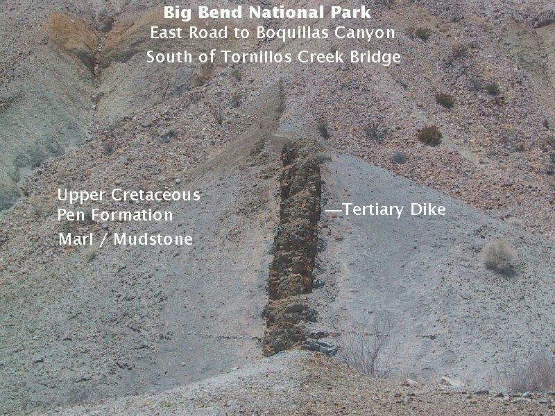
What you see in the above picture is an igneous dike that penetrated the Upper Cretaceous (about 85 million year old) Pen Formation, consisting largely of limey clays deposited in a shallow sea. The Pen Formation lies on top of limestones deposited in deeper waters and is overlain, where not exposed by erosion, by the Aguja formation, which grades stratigraphically upward from marine to terrestrial deposits and thence into the terrestrial Javelina Formation. Hence the Pen Formation marks the beginning of a transition in Big Bend history, when the sea was gradually receding as the land rose, eventually to be visited by volcanism during the Eocene, beginning around 50 million years ago. The dike, however, may have been emplaced during a later volcanic episode, some 30 million years ago. The discoloration of the Pen around the dike is due to the rocks being baked by the hot magma.
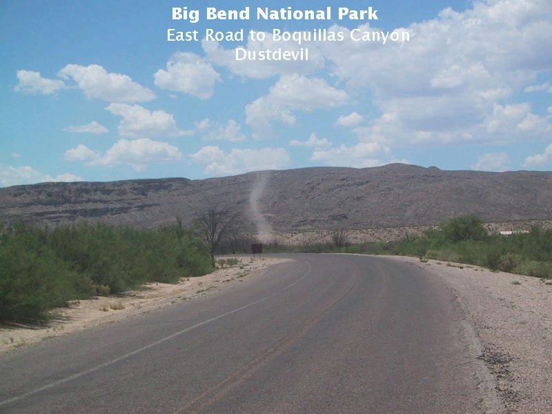
We saw a couple of fine dust devils during our Big Bend trip. Unfortunately, I don't have a picture of el primer one, because my brother kept trying to maneuver his car to get the best perspective. Dust devils don't last long, as I pointed out to no avail, so we ended up with a great perspective of an empty desert scene. (Grrrr!) The one below wasn't bad but not nearly as impressive as the huge one we had seen the first day we were there. I should point out that the dust devil is a lot farther away - and therefore much larger - than it appears in the image.
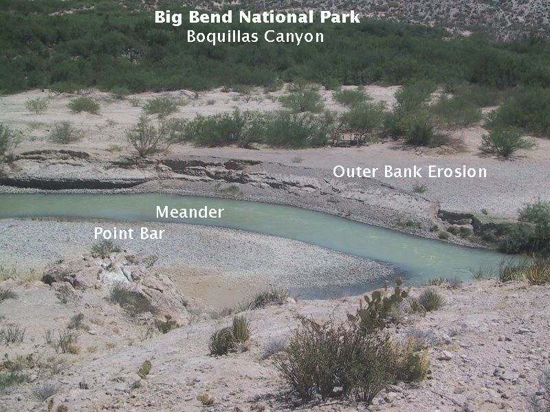
Hiking up the trail to the entrance to Boquillas canyon, you are treated to some nice views of the Rio Grande with scenes of fluvial geomorphology (landforms associated with rivers and streams). In the view below you see a meander in the Rio Grande with a point bar on the Mexican side. Meanders form due to the river encountering resistance to its downslope flow and apparently result from the river minimizing its energy. A point bar is an area of deposition on the inner, quiet-water side of the meander. Also in the picture is what appears to be a new channel forming. Meanders tend to grow larger and more "loopy" with time to the point a new channel will form, cutting across the loop and shortening the distance the water flows.
Update. I have received a clarification regarding the above paragraph from Jeff Bennett of the National Park Service in Big Bend National Park. I'll let him explain in his own words.The floodplain channel on the Mexican side is not the Rio looking for a new course, rather it is created by the outflow of a spring. It is one of a complex of springs on both sides of the river. Flooding in 2008 obliterated the previous channel. If you were there after the flooding, then you might have noticed that there were two similar springs on the river left entrance bar.A big "thank you" to Jeff Bennett for that contribution. If any errors are found by readers, I would very much appreciate learning about them.
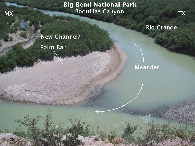
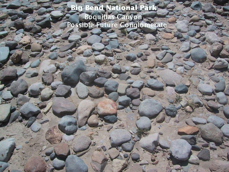
A closer look at the material making up the point bars indicates it consists of well-rounded cobbles in a matrix of sand. Obviously, the flow of the river at the time we visited was insufficient to move this material, so the deposition had to have occurred at times when the river was flowing much swifter and deeper - that is, during flood stage. Were this point bar to be buried due to some change in the current depositional/erosional pattern and lithified (turned into rock), it would become a conglomerate (a rock containing abundant gravel to cobble to even larger rounded rock pieces).
This next view is a bit farther along the trail, where you can see the erosion caused by swifter moving water on the outer bank of the meander. Erosion of the outer bank accompanied by deposition on the inner bank is the mechanism by which the meander grows. Rivers, therefore, due to meander growth and the formation of new channels, are constantly changing their courses. This behavior of rivers greatly annoys politicians trying to define intranational and international boundaries.
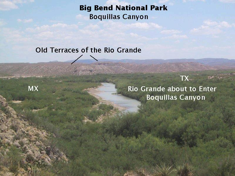
Even farther up the trail and looking upstream, you can make out old terraces of the Rio Grande: the mesa-like landforms in the middle distance. These formed when the erosional/depositional environment was different than it is today. These terraces appear to be erosional remnants of the previous valley surface, left as the river's downcutting power increased, possibly due to one or more episodes of uplift (an increase in the elevation of the surface of the land) or a change in climate. (The climate was wetter during the last glacial maximum, which peaked around 20 000 years ago.) From our point of view, there appeared to be at least two, maybe three, former valley floors now serving as tops of these mesas. The "at least two" are likely the Qiw1 (lower) and Qiw2 (upper) terraces of Berry and Williams (USGS Circular 1327), dating to the middle to late Pleistocene. In the past, they were floodplains, such as the present floodplain: the flat area on either side of the Rio covered with vegetation. (I need to point out that these features are in Mexico and not included on geologic maps of the Big Bend, so I have had to exprapolate from what is mapped on the U.S. side. However, I think the identifications made above are correct.)
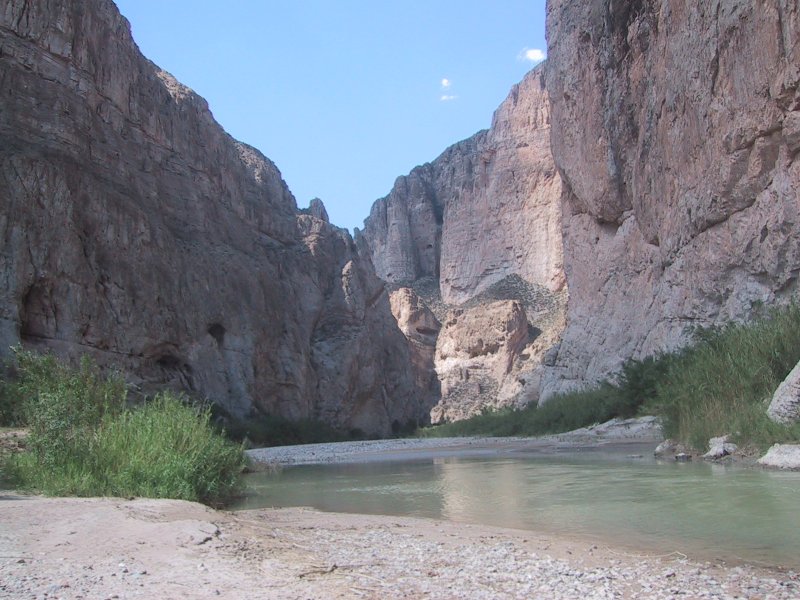
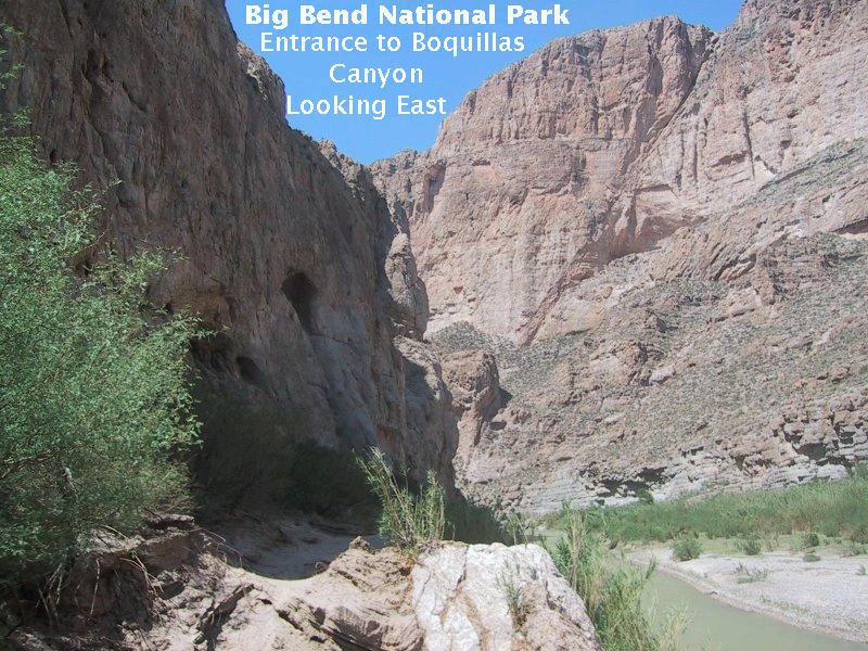
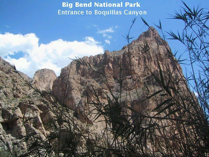
Now we are about to enter the canyon itself, and the image below is what you see: steep walls of Santa Elena limestone, deposited in a sea during the Lower Cretaceous. The limestone has been exposed by the river eating down through softer Upper Cretaceous rocks (now completely removed at this location) and into the harder limestone. The theory is the river channel was trapped and had no option but to continue eroding down. Its tools were silt, sand, and gravel scraping along the river bottom. The mouth of the canyon appears to be at the east side of a down-faulted block of rock called a graben, which apparently is responsible for the escarpment you encounter entering the canyon.
If you have good powers of observation, you may have noted in the image above what looks like a fracture in the limestone wall. If you observational powers are sharp enough, you may even have thought it appears that the rock has slipped along the fracture. You would be correct. What you are looking at is one of the best examples of a normal fault I have ever seen. A fault is where rock slips along a fracture. A normal fault is where the footwall moves upward with respect to the hanging wall (see the figure below - the fault plane slopes away from the footwall block). There appears to be several hundred feet of displacement along this fault. (Six hundred feet is what I've read.) This fault appears to be a branch of the same fault system marking the eastern edge of the graben mentioned above. The canyon walls are about 1500 feet high.
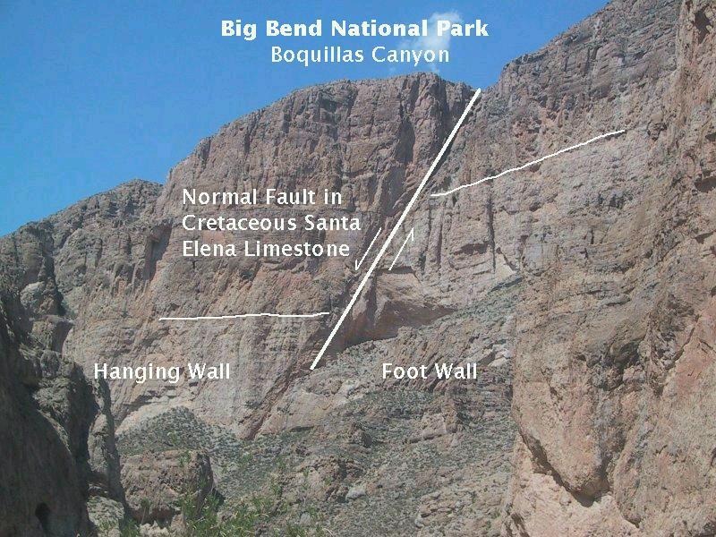
The terms "foot wall" and "hanging wall" have an interesting origin. Some faults are locations of ore that miners could exploit. The foot wall was where they stood while working and the hanging wall was where they hung their lamps.
Leaving Boquillas Canyon is as spectacular as entering it. This is the view you get after you have gone as far as you can and turn around to leave. Unfortunately, you have to fight the Corrizo cane (or giant cane) on this hike, which is an exotic (not native) species that has taken over the banks. Areas of burned cane may be due to efforts of park personnel to eradicate it. It is a very fast growing and thirsty plant, and has been fingered as partly responsible for the reduced flow in the Rio Grande.
FORWARD to the Hot Springs Trail
BACKWARD to the Boot Canyon Trail
ALL THE WAY BACK to the Contents