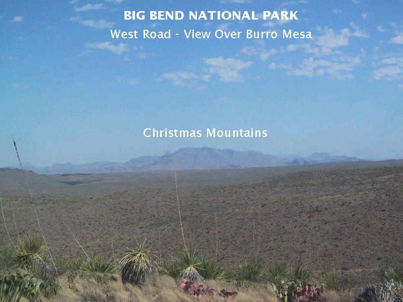
My brother got annoyed at me because I kept pronouncing "Burro Mesa" as "Bureau Mesa". I didn't mean to. For some reason I just couldn't help myself. The mesa was named, not for federal bureaucrats that once roamed there, but for the feral burros that have since disappeared. The picture below is taken over the top of the mesa from Sotol Vista, looking NNW. The mesa is topped by Quaternary and late Tertiary sediments which are underlain by the 29 million-year-old Burro Mesa Formation and the older Chisos Formation. (When this feature was first put together, the Chisos Formation had been renamed the Chisos Group. A "group" contains two or more formations. Now it is back to being a formation, but the original of one of the photos is lost, so I've struck out "group" and replaced it with "formation" on that photo.) Beyond the mesa are the Christmas mountains, consisting of Cretaceous limestones and igneous rocks. (My apologies for the photo which used to be in this spot. It was incorrectly labeled.)
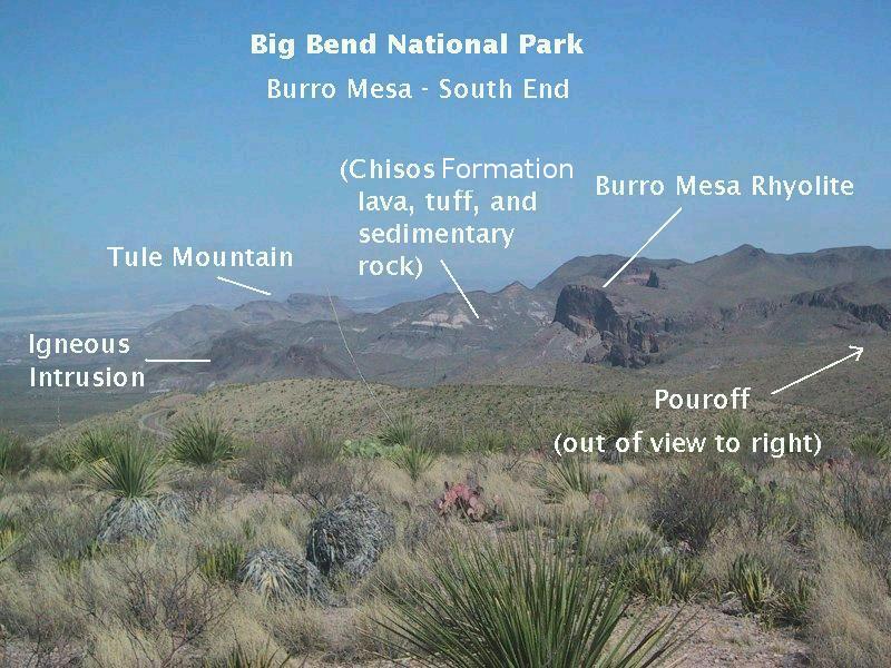
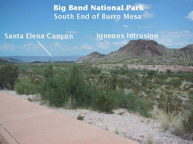
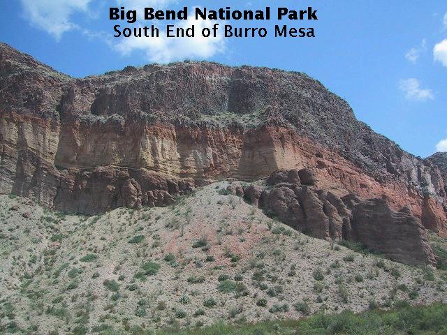
As you approach the south end of Bureau..., er Burro Mesa on Ross Maxwell Scenic Highway, the view below greets you. The south end is marked by an escarpment in the Burro Mesa Formation, which overlies the Chisos Formation, which consists of lava flows, tuffs, and sedimentary rocks largely composed of eroded fragments of volcanic material. An igneous intrusion is seen just to the left of the south border of Burro Mesa. This is an intrusion of magma of basaltic composition, a composition rich in iron with reduced quantities of silica (silicon dioxide). The iron content makes basalt a dark-colored rock. This intrusion dates to 29.0 million years before present.
Big Bend National Park is full of pouroffs of various sizes. They are intermittant waterfalls, usually dry, and the higher ones can be show-stoppers for hikers trailing up a stream bed. Others you have to scramble over or find a route around. The Burro Mesa Pouroff forms a box canyon that stops you in your tracks. As indicated below, it is out of the picture to the right (and can't be seen from here anyway).
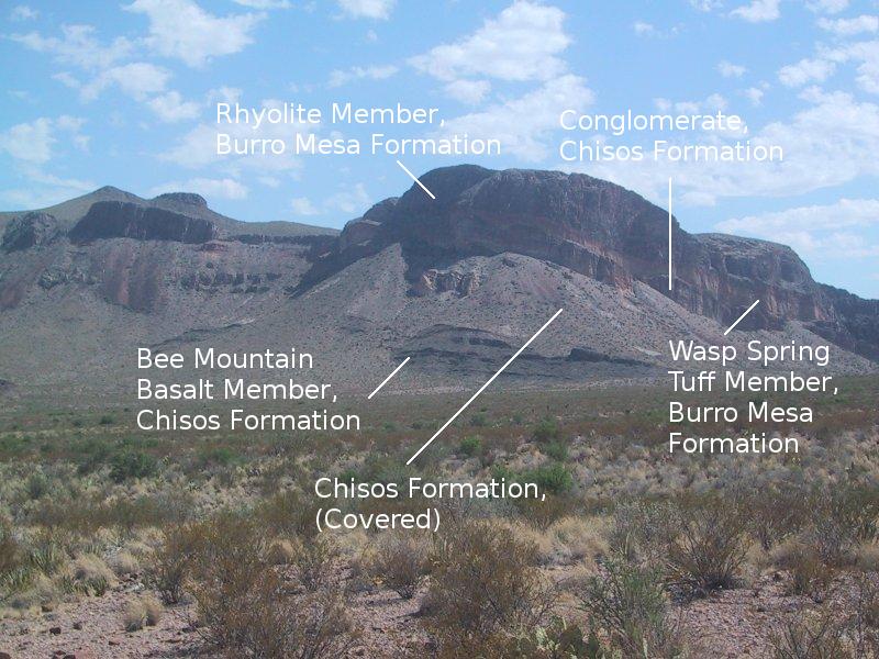
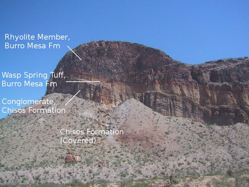
Viewed from the trailhead (below) to Burro Mesa Pouroff, the escarpment at the south of Burro Mesa exposes the highly resistant Burro Mesa Rhyolite on top of the Wasp Spring Tuff. These two units comprise the Burro Mesa Formation. Both are volcanic rocks high in silica. The tuff, in turn, lies over a conglomerate belonging to the Chisos Formation. There is an unconformity between the Wasp Spring Tuff and the conglomerate. An unconformity is where there is a gap in the geologic record and typically a long period of net erosion, in this case something like one or two million years. The conglomerate is partially covered with talus, as is whatever is directly underneath. However, the Bee Mountain Basalt member of the Chisos Formation crops out at the base of the escarpment. The Bee Mountain Basalt actually consists of a number of lava flows that erupted between 30 and 34 million years ago, but there are no dates of the rock at this location as far as I know.
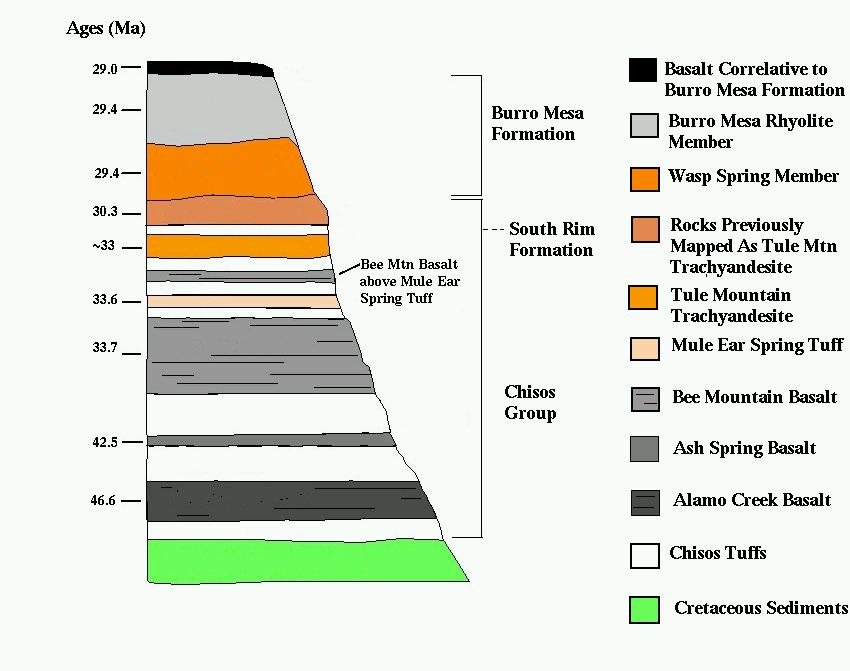
A generalized stratigraphy adapted from Miggins et al in USGS Circular 1327 appears below. Apparently the Tule Mountain Trachyandesite (an alkali-rich volcanic rock) and units previously mapped as this trachyandesite are missing here. Instead, the aforementioned conglomerate, rather than the trachyandesite, lies below the Wasp Spring Tuff. Note that the Chisos is labeled a "group" rather than a formation in this graphic. Plus, the updated identification and nomenclature of rock units due to recent USGS work confines the South Rim Formation to the Chisos Mountains such that it does not appear here.
The above view was toward the north. Looking back toward the south you see a notch in Mesa de Anguila, marking Santa Elena Canyon. Also in view is the igneous intrusion previously pointed out.
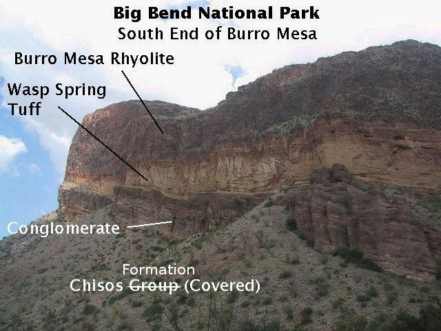
The trail to the pouroff is an easy one, although sometimes biting flies discourage casual hikers from reaching it. Insect repellant is a smart thing to have along. (We didn't have any; we just fought the flies as best we could.) The image below is early in the hike. You see part of the escarpment with the Burro Mesa Rhyolite above the Wasp Spring Tuff. Note how the tuff plays out ("pinches out") to the south, indicating its source was farther north. You can also see how occasional rock falls are eating away at the escarpment. Note the large boulder of tuff lower center-left.
Below is another view of the escarpment farther up the trail. The tuff appears to have been chemically and/or physically altered by the rhyolite extruded on top of it. Note the discoloration of the tuff just below the rhyolite. The reddish color may be from iron that diffused into the tuff from the rhyolite. Both the Wasp Spring and the rhyolite have been dated here. The Wasp Spring comes out at 29.5 and the rhyolite at 29.35 million years old. The error bars on these dates overlap, so the units may actually have been erupted at nearly the same time.
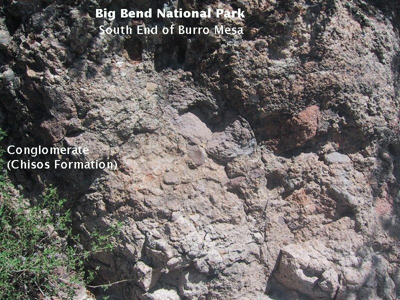
In this view of the same part of the escarpment as above but at a different angle, note the way the conglomerate weathers into rounded shapes, with layers of stratification apparent. The rounded clasts of the conglomerate and the stratification indicate it was deposited by running water.
Below is a closeup of the conglomerate. You can see the rounded gravels and cobbles cemented together to make up the rock. According to the Texas A&M website, the gravels and cobbles are quartz and rhyolite cemented in a matrix of tuffaceous sand.
After a thirty-minute or so stroll, you are at the pouroff itself. If you go back and look at the images of the Burro Mesa escarpment, you can see that the beds are dipping in a northerly direction. So, even though your increase in elevation is negligible from the trailhead to the pouroff, you find yourself at the same level as the northerly dipping Wasp Spring Tuff when you reach the pouroff.
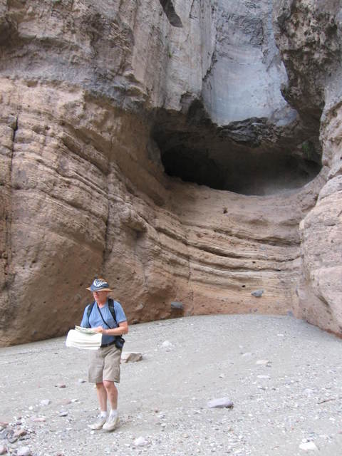
My brother stands at the bottom of the pouroff in front of an outcrop of Wasp Spring Tuff. Above him is a cavity at the top of the tuff, below the Burro Mesa Rhyolite, which as been polished smooth by sediment carried over the pouroff during the occasional desert rainstorm. I speculate that the cavity was formed when the ground level was at the base of the rhyolite. The top of the tuff may be less resistant to erosion due to modification during the rhyolite flow. A plunge pool forms at the base of a waterfall, and the swirling water containing sediment eats back into the rock at the base. This causes waterfalls to retreat upstream. The same thing could have happened here when the climate was wetter during the last glacial maximum if the altered tuff was susceptible to erosion.
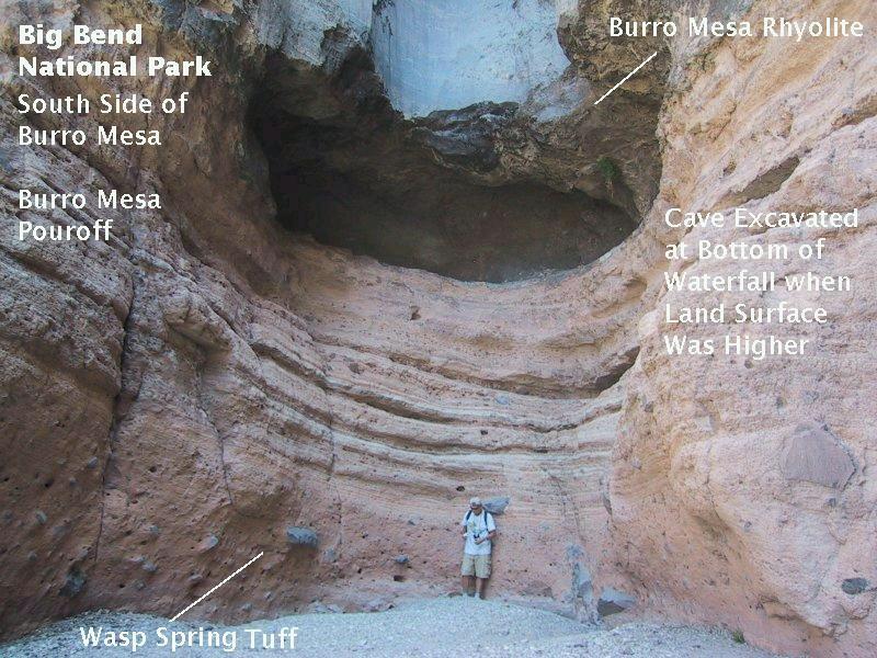
Notice the large rocks embedded in the tuff in the above image, some the size of boulders. Obviously, the eruption that produced the tuff was fairly violent to have been able to throw boulders from the site of the eruption.
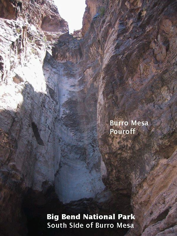
Finally, here is the view looking up the pouroff. One source said the pouroff was 40 feet high and another said 150 feet. If 150 feet is correct, then it must include the entire drop and not just the shear drop. On the other hand, it is quite clear the cliff is well more than 40 feet high. I estimate about 110 feet.
From here it appears the water comes over the gap above which you see blue sky. However, on a later trip, we hiked to the top of the pouroff, and the water actually comes through a crevice on the left, not very visible in this photo. There is a sort of plunge pool just before the lip of the dropoff, which was filled with cold water when we were there in the summer of 2009.
FORWARD to Dog Canyon
BACKWARD to the Maxwell Scenic Highway
ALL THE WAY BACK to the Contents