All Cows Go To Heaven: (Beef is in demand there.)
Back in October, 2015, the River Road was almost impassable after floods hit Big Bend. During this trip, in June, 2016, the road was nearly unrecognizable, at least in parts. Gone were the long stretches of mud and muddy water that made me think of turning back more than once. The road had been re-graded, and although still not suitable for a stretch limousine or even your Lexus (high clearance required, four-wheel drive recommended), it was a veritable super highway compared to last October.
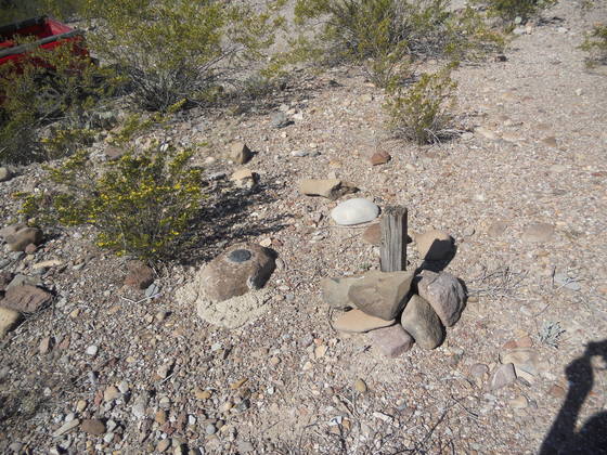
At points along the road you will find US Geological Survey (USGS) benchmarks like the one pictured below (benchmark 2302 about one mile east of Buenos Aires). This one was originally placed at some time in the past – not readable due to the resetting that was done in 1943. The old writing was pretty messed up. These benchmarks are to mark position and elevation, although I'm not sure how useful they are now that there is GPS technology.
My first hike this time was to be to Cow Heaven Mountain, which is on an anticline – an up-fold of rock due to compressive forces. I have seen cattle in this part of the park; I assume them to be cattle – possibly feral – that have crossed over the Rio from Mexico. In fact, I saw four animals while nearing my campsite at Dominguez trailhead: two adults, one yearling, and one calf. However, the picture I took didn't turn out. (I need a camera with a viewfinder, rather than a screen which is almost impossible to see in bright sunlight.) When I said, "So long cows!" they spooked and galloped off.
I'm wondering if cattle have somehow heard of Cow Heaven Mountain and take its name literally. On my way to the mountain the next day, I came across numerous hoofprints and abundant cow pies. The landscape looks nothing like a heaven for cows to me. All I saw that they might eat, other than brush, was this coarse sedge. This stuff is a danger to cross-country hikers – more about that later. Plus, there are no springs anywhere near the area as far as I know. The closest water appears to be the river.
June wasn't my optimum time of the year for this trip, but plans to come out in March fell through. My brother was smarter. He camped up in the Chisos to do his birding. It was 100 degrees in the afternoon with the heat index at or above 115 in the sun. When we first arrived at the park, there were clouds. Not so when I got out on the desert. No clouds, no shade, and one day hardly a breath of wind. I love the desert, but this was about as brutal as I can stand. There was no one else around as far as I could tell. I was the only bonehead out there.
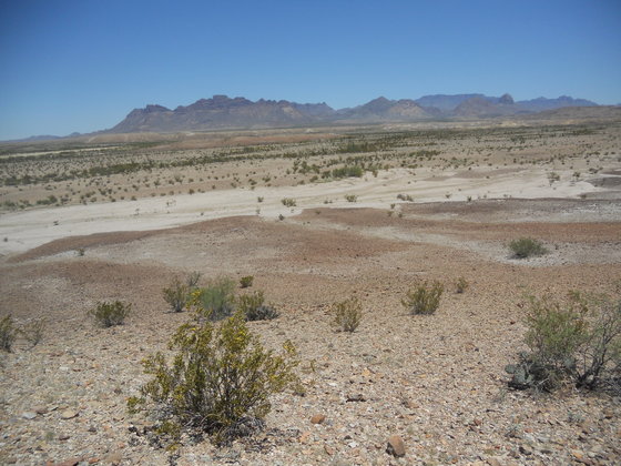
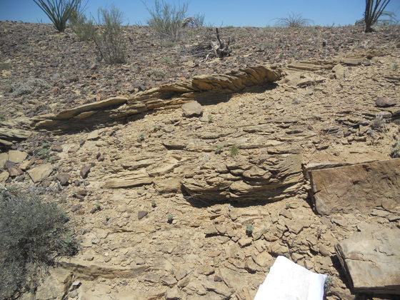
It's time to pack some water and head off to Cow Heaven Mountain. First up was to take a look at some outcrops of the late Cretaceous-Paleocene Black Peaks Formation (roughly 70 to 60 million years ago as indicated by dinosaur and Paleocene mammal fossils). This formation is composed of clays of various colors, weakly held together so that it forms slopes rather than ledges or cliffs, although sandstone and fresh-water limestone has also been reported (units I've not come across). A typical outcrop not far from the Dominguez trailhead is pictured below.
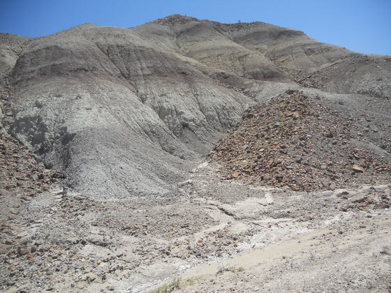
The following photo shows how the weakness of the Black Peaks material causes stress cracks above a steep slope. Thus the outcrop continues to wear away. The gravel on top is debris deposited on the surface of the Black Peaks — not part of the formation itself. Also notice the Punta de la Sierra in the distance.
The cliffs of the Punta de la Sierra consist of trachyte, which is a volcanic rock rich in alkali metals — roughly the volcanic equivalent of granite but with more abundant alkali metals and little or no quartz. The silica in the magma was largely used to make feldspar before much quartz could form, as quartz is one of the last minerals to crystallize out of magma. It is thought by some that this trachyte was derived from eruptions of the Dominguez Mountain volcano during the Oligocene (23 - 34 million years ago). The slopes of the Punta de la Sierra below the cliffs are mostly colluvium covering Chisos Formation rocks dating back to the Oligocene and Eocene (34 - 56 million years ago). Colluvium consists of debris from the erosion of the mountains deposited by various processes not involving transport by water. The Chisos rocks are a mixture of sedimentary and volcanic deposits. The Punta de la Sierra is an erosional remnant, owing its existence to the resistant trachyte rocks, which are, nevertheless, being gradually worn away from all sides — like the Black Peaks in the picture but more slowly.
This is going to take guts, but I'm going to admit to a rookie mistake in using my compass. I'm not sure exactly what the mistake was, other than it was due to being overconfident. I left the Black Peaks outcrops and made my way to the northeast toward Cow Heaven Mountain. I stopped to check my compass to make sure I was heading the right way. After walking a mile or so across the desert floor, I came across a well-maintained road. What the hell was this doing here!? I was nonplussed. According to the way I was going (or thought I was going), the road was heading almost north. There was no road indicated on the maps. Was this a road that was newly constructed by the park? Why would they need such a nice road heading up the west side of Cow Heaven Mountain?
My confusion lasted a few minutes when I finally realized, "Hey, this is the freakin' River Road!" Sure enough, straight ahead in the distance was Mariscal Mountain. I had been so absorbed in looking at the nearby landscape I hadn't noticed that that was where I was heading! Did I ever feel foolish! I almost swore than no one would ever hear of this. But, then, maybe it would elicit a few chuckles in the readership, so, ahem, here it is.
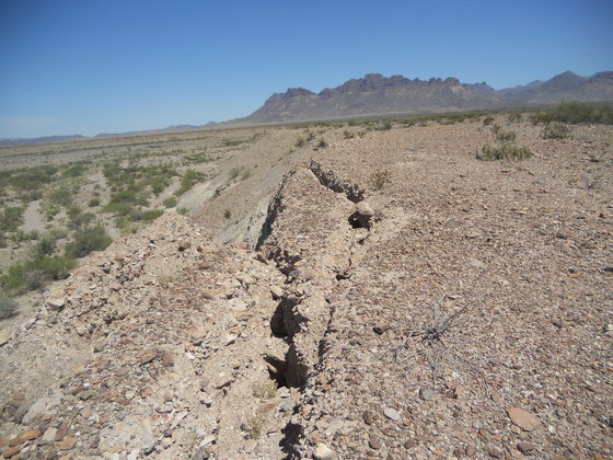
There was a small hill just to the north of the River Road, so I used it to take a panorama of pictures. In the following you are looking back westward toward the Dominguez trailhead, which is in the direction of the left edge of the Punta de la Sierra. The low hills in that general direction are Black Peaks; the low hills on the right half of the photo consist of the Javelina Formation – upper Cretaceous rocks lying stratigraphically just below the Black Peaks that, like the Black Peaks, are also mostly varied colors of clay. According to Lehman and other authors, there is a tuff bed in the middle of the Javelina that has been dated radiometrically to be between 68 and 70 million years old. The arroyo in the foreground is covered with relatively young (Holocene, about 12 000 years old or less) alluvial (water deposited) material.
There has apparently been quite a bit of confusion in differentiating the Black Peaks Formation from the Javelina Formation. For example, much of the Black Peaks in the western part of the park was originally mapped as Javelina. Using Google Earth I could not distinguish the two on the satellite images, and I'll bet there are still adjustments to be made on future maps. I'm not sure how geologists recognize them in the field; possibly based at least partly on fossil evidence. Certainly, a fossil of a Paleocene mammal would show the deposit that contained it to be Black Peaks.
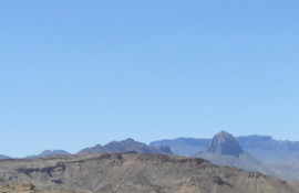
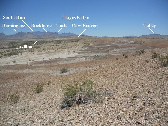
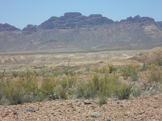
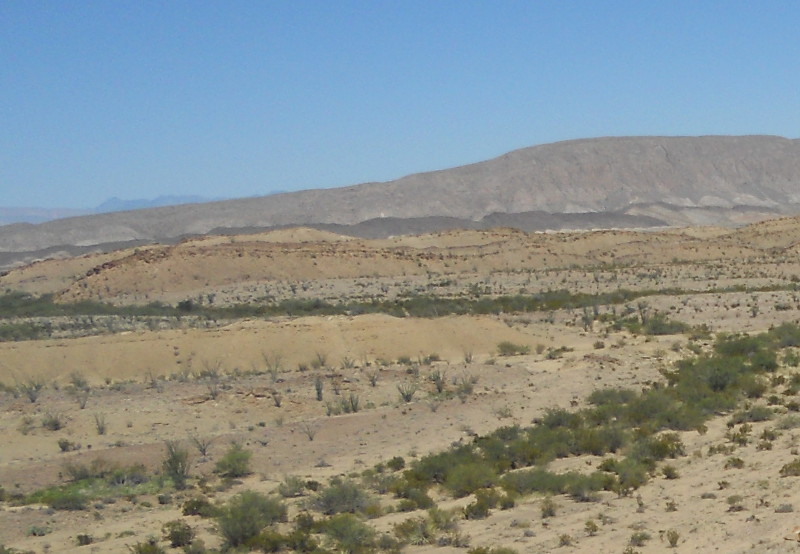
The next photo is looking toward Cow Heaven Mountain in the distance. The dark rock on top of Cow Heaven Mountain is igneous rock deposited after the anticline was formed. In addition to Cow Heaven Mountain, you can also see, left to right, Dominguez Mountain, Backbone Ridge, Elephant Tusk, and Talley Mountain at the far right. In the far distance are the Chisos Mountains, featuring the South Rim and Hayes Ridge.
The final photo I'm presenting from this little hill is looking east across the River Road toward some low hills of the Javelina Formation. Notice the yellow coloration of the clays, visible in spots. Both the Javelina and Black Peaks sport yellowish clays in some horizons, but my limited experience is that the Javelina seems to have more of them.
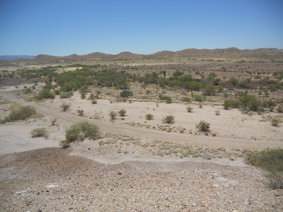
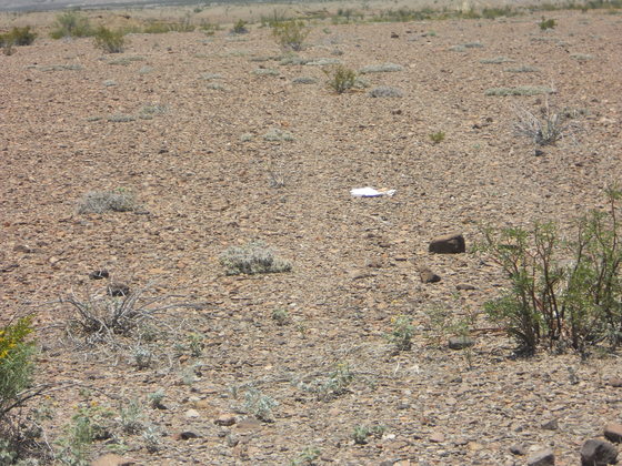
Speaking of finding roads, in the next picture is an old road I came across while getting close to the Cow Mountain anticline. If you look carefully you can see faint tracks on either side of the maps I have placed on the ground. When I got back to Austin, I found the road on Google Earth. It is not easy to see, but you can find it if you know where to look. The road ran from the River Road about 1000 feet east of the turnoff to Woodsons campsite up along the west side of the Cow Heaven anticline. Had I known this was here, I could have saved myself a lot of tiring hiking. However, unless you know its there (not shown on the topographic map) you would likely not find it were you to examine the area on Google's satellite images while scoping it out for a hike.
This next picture is a telephoto looking toward Punta de la Sierra. The multicolored clays of the Javelina Formation are clearly displayed. At this point I was on the western edge of the Cow Heaven anticline.
The edges of the Cow Heaven anticline are composed of tilted beds of the Aguja Formation of the late Cretaceous. These rocks were deposited as Big Bend transitioned from a marine to a terrestrial environment. A pyroclastic deposit in the upper part of the formation dates radiometrically to around 77 million years ago, according to Breyer, Befus, and others. Pictured below is a cross-bedded sandstone unit in the Aguja not far stratigraphically above the base of the formation. This type of deposit could reflect the texture of underwater sand dunes. The cross-bedding seen in the picture records deposition by flowing water that changed in both speed and direction from time to time.
Finally, here we are just south-southeast of Cow Heaven Mountain close to the axis of the anticline, the trace along the surface of the line of greatest folding of the rocks. I'm standing on rocks of the Aguja Formation just to the west of the axis, looking north toward the mountain, framed here by, from left to right, Dominguez Mountain, Backbone Ridge, and Elephant Tusk. Much farther away are the South Rim and Hayes Ridge. The dark rock on top of the mountain is intrusive igneous rock, undated but emplaced sometime during the Eocene and/or Oligocene. This rock is "mafic", a word from the combination of magnesium and ferric/ferrous (iron). That is, these rocks are typically rich in these elements and are likely of basaltic composition at this location. They postdate the formation of the anticline, which occurred during the Laramide orogeny, a mountain-building tectonic event that affected western North America during the later part of the Cretaceous through the early part of the Tertiary Period.
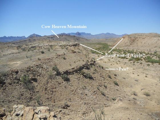
You should be able to see that the Aguja rocks on the left dip slightly to the west while those on the right dip slightly east. This indicates I am close to the axis of the anticline where the beds should be nearly horizontal. At the base of the Aguja there is a bed of sandstone, so I'm thinking the sandstone bed in the picture is this basal unit. If that is true, the sediment below it belongs to the Pen Formation, also upper Cretaceous. Like the Javelina and the Black Peaks, the Pen consists largely of clays and so forms slopes. I encountered the basal sandstone of the Aguja in an earlier trip to the Banta Shut-in as a thicker and harder unit.
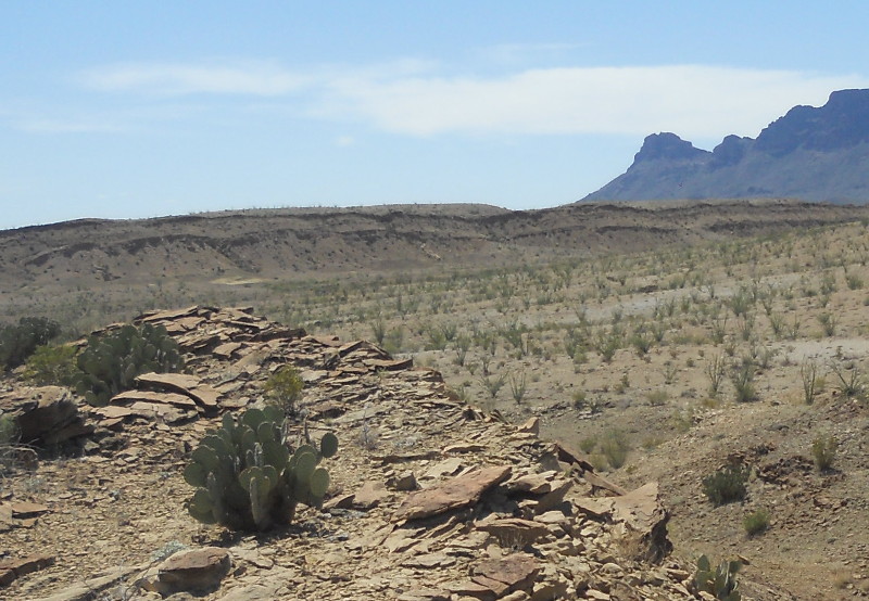
The two pictures below are closeups of the dipping Aguja beds on either side of the anticline. An anticline is an upward folding of rock, usually in response to compressive forces, such as when you put your hands down on a bed blanket and move them towards each other. This anticline has been breached by erosion such that the middle is largely missing to the south of the mountain, leaving the rocks on either side (to the east and west) widely separated by the drainage that has formed in the center. The first picture is to the west where the beds appear to be dipping west at an angle of 20 degrees or better. The second is of the beds on the east side dipping toward the east. The mountain in the distance is Mariscal Mountain, and the dark hills consist of intrusions of mafic igneous rock.
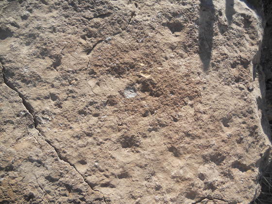
As you can see in the pictures, there is practically no shade available when the sun is high. The only shade I could find for a rest was on the side of the rock pictured below, and even that was uncomfortable due to the rock being at an odd angle. To make matters worse, the soles of both my boots came loose at this point! One came off entirely while the other was only hanging on to the toe region. I had to complete the rest of the hike with just the inner sole of one boot and dragging the outer sole of the other so it wouldn't come off. However, my stop allowed me to notice the smattering of tiny marine fossils in the rock. Lack of time and footwear precluded me from looking for fossils more intensely.
After my exploration of the anticline, I was not looking forward to returning the way I came, hiking over sharp rocks and up and down slopes with challenged footwear. The road I had found was quite a way west also. I decided to go down the drainage to the River Road. One problem. The sedge. This crappy stuff covers huge swaths of the drainage. If it were just walking through the lumpy vegetation, it would be tedious but doable. The real problem was the fact that the sedge roots cling tenaciously to the dirt in the drainage, forcing the water from flash floods to travel in between, carving deep ruts, often more than a foot deep, that can break a leg if you aren't careful. I don't know how the cattle negotiate this, and the sedge flats appear to be a great place to cripple a horse were anyone so foolish as to ride across them. As a result I traveled down the west side of the anticline, following close to the dipping Aguja rocks on the higher ground where less sedge was found. The east side of the anticline may have been better, but hell if I was going to cross the sedge to find out. If anyone aims to visit this heaven for cows, I suggest finding that old road and following it up. Don't go into the drainage! Save yourself!
BACKWARD to Dominguez Mountain
FORWARD to Talley Mountain
ALL THE WAY BACK to the Contents