The Devil's in the Details: Devil's Den
Note: The devil (or possibly Murphy) did too much meddling in the details, so I have made some revisions.Yes, the devil is in the details, and there are some details that got messed up along this hike. The first detail that needs to be mentioned is that the hike to Devil's Den is much better marked than in the past. Unfortunately, my brother and I didn't know that, so we had some unnecessary trouble finding the correct route. I hadn't planned to do this hike, so I hadn't brought the proper quadrangle maps. In the past I brought everything – every map and geology publication I had – and ended up using only a tiny fraction of it. So this time I was going to be smart. (Ahem) Next time I'm bringing everything again. All we had was the second edition of Hiking in Big Bend National Park by Laurence Parent, which I understand is not the latest edition and was written before the recent changes to the trails here were made. We headed out cross-country without a quad, totally ignorant of the fact that farther down the trail to Dog Canyon, a trail to Devil's Den marked clearly by a sign splits off to the right. One detail down, a few more to go.
And here's another. Now, you can choose to hike up through the "den" or, as we did, hike along its rim. For our purposes this was by far the better choice, as the hike through the den, according to Parent (not to mention what we saw from on high), is difficult. More to my advantage, the geology is much easier to observe by taking the high road. Also, you get vistas that you can't get down in the den, a narrow canyon with sheer walls. There is no sign where the trail splits when we were there, telling you which is the high road and which is the low road, just cairns marking the two separate paths, but go to the right if you want to hike along the rim of the canyon. Go to the left if you love boulder hopping. The only drawback in taking the high road is you might run across certain scary denizens of these upper reaches. After all, this is the den of the devil.
The telephoto below, credited to my brother, Randy (as are many of the photos in the virtual field trips), is of Devil's Den in morning light from the main road, looking east. The trail up the right side of the canyon rim ends at a fault scarp, across from which you see the results of the Santiago thrust fault. More about this thrust fault later. Note the nearly vertical beds in the right of the picture – consequences of the thrust fault. It may not be clear in the photo, but the mountain on which the nearly vertical beds reside is beyond the conical-shaped mountain toward which Devil's Den trends. There is a drainage that separates them.
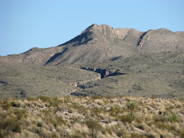
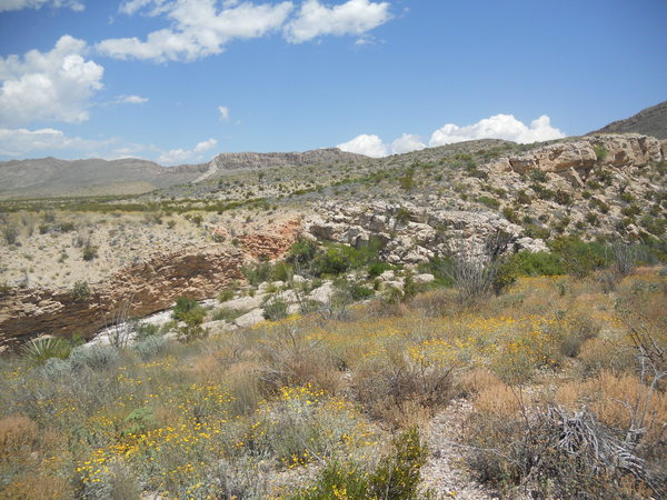
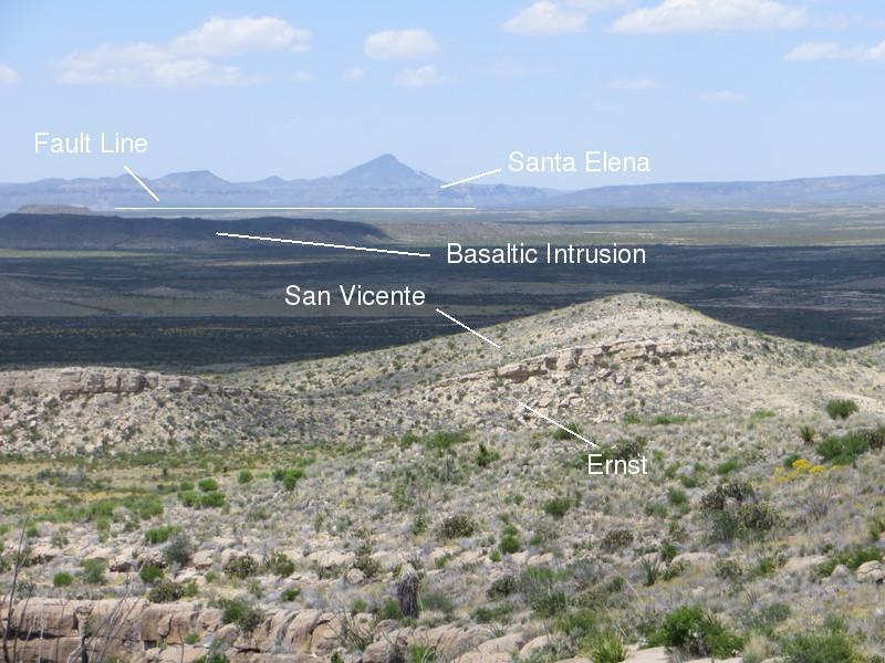
The photo below was taken as we were painfully making our way unnecessarily cross-country. At least here we had an arroyo to follow. The picture is back to the north from whence we came. My brother, the birder, has heard a bird call and is looking for its source. In the distance is the southern end of the Santiago Mountains with Dog Canyon out of sight off the the right. The prominent cliff is the Santa Elena Limestone. The rock of this escarpment, to be discussed later, has been really messed up.
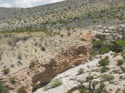
Here is another one of those devilish details – at my expense. In the picture below you see this orangish rock resting on grayish-white limestone. I identified it in these pages previously as the Del Rio Clay. The new USGS map of the park (Scientific Investigations Map 3142, 2011) identifies it as the Boquillas Formation. However, it was resting on the Santa Elena Limestone as far as the USGS map was concerned, so it had to be the Del Rio Clay. What I figured out later was that the map color for the Santa Elena Limestone was almost identical to that of the Buda Formation! (Or maybe I'm a bit color blind in that part of the visible spectrum.) Not helping is the fact that the Boquillas and the Del Rio can look very similar from a distance, and this view was devilishly similar to how the Del Rio on the Santa Elena looks like at Ernst Tinaja. Anyway, going back over the pictures we took and the map, I think the map is correct after all. Taking a hard look at the map I can just barely, maybe, make out the color difference. (By the way, in the background you can see the rockfall that occurred in 1987, making a roar heard for miles.)
Below is a closeup of the contact between the Boquillas and the Buda. Clearly a drastic change in deposition occurred as recorded by this contact, but the contact is not conformable, implying some time passed between the Buda and the Boquillas depositions. Both the Boquillas and the Buda are marine deposits, as indicated by their fossil content, but with the advent of the Boquillas, more terrestrial sediment was introduced, and the deposition changed from the slow accumulation of lime to a more rapid accumulation of fine terrestrial material along with the lime.
Even though the above photo is not of the Del Rio Clay resting on the Santa Elena Limestone, the Del Rio is found near Devil's Den and, certainly, it is an anomaly in the otherwise mostly limestone dominated Cretaceous System in Big Bend. There appears to be a sudden change from limestone to clay with the advent of the Del Rio deposition, and a sudden change in deposition once again as the Buda Limestone took over from the Del Rio. These sudden changes strike me as a bit of a mystery. In the case of the Del Rio, the fact it is thicker in the northern areas of the park compared to farther south and east implies the likely source of the sediment was to the north and west. Possibly a rather sudden (geologically speaking) regression of the sea occurred followed by a rather sudden transgression. The land, a source of terrestrial sediments, would be closer during the regression. However, the Del Rio and subsequent sediments are upper Cretaceous, whereas the Santa Elena is lower Cretaceous, so the sudden change between the Santa Elena and the Del Rio may be more apparent than real.
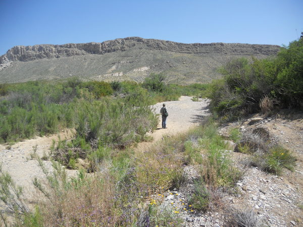
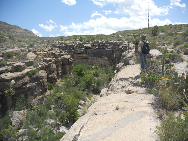
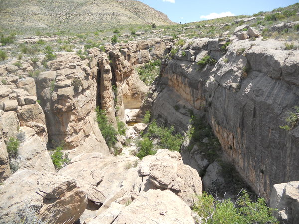
The following picture, looking in a generally easterly direction, is of the lower reaches of Devil's Den. The narrow canyon was formed when a stream wore down through material overlying the rock now present at the surface as the land was uplifted. It eventually encountered the Santa Elena and became entrenched, creating the Den. This is also the origin of Dog Canyon. Today, the (usually dry) stream drains into Nine Point Draw, which runs through Dog Canyon.
The canyon almost looks man-made, as if a vertical trench were dug and lined with concrete blocks. The "blocks" are actually limestone of the Santa Elena. Note the bouldery rubble in the Den. These blocks fall from the wall as the Den slowly widens and deepens over time. I'm pretty sure most of this erosion takes place during rare but violent flash floods. The going down below does look rough. When we saw this, we were glad we were above all that.
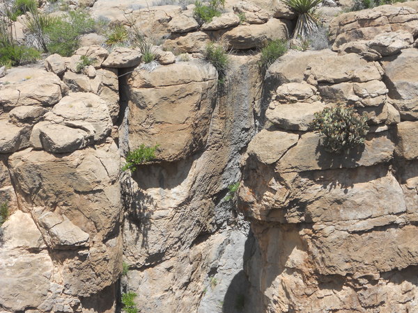
In addition to the force of flash-flood water and the erosive material carried with it, the rock is also gradually weakened by chemical weathering of the limestone. Below you see some evidence of that. Just above and to the left of the center of the picture there is a block that seems to be in a precarious position. Note the weathered nature of the rock below it and to its right as indicated by the grayish discoloration. This block may soon join the jumble below. (Soon in the geological sense, that is.)
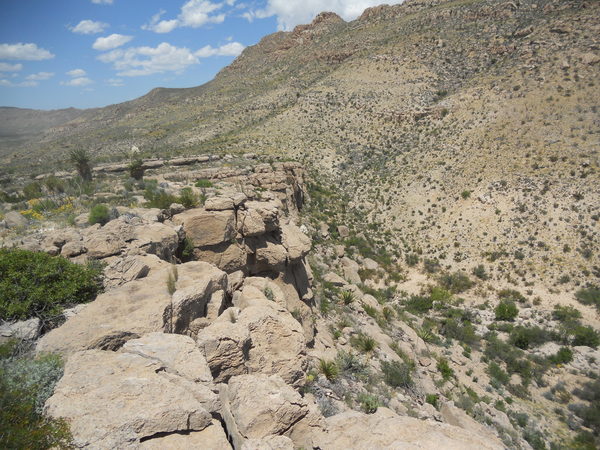
The hike up the southern rim of Devil's Den is not at all difficult, as you gain elevation at a modest pace. Looking back from whence you came, you see this wide-open space of desert floor. This broad, flat region is due to a structural feature, the Chalk Draw Graben, a down-faulted crustal block. As indicated in the picture (looking west-northwest) the far side of the graben ends at a fault, the Chalk Draw Fault located about two miles this side of Nine Point Mesa. This side of the graben is bounded by a monocline, to be discussed below, and the faults associated with it.
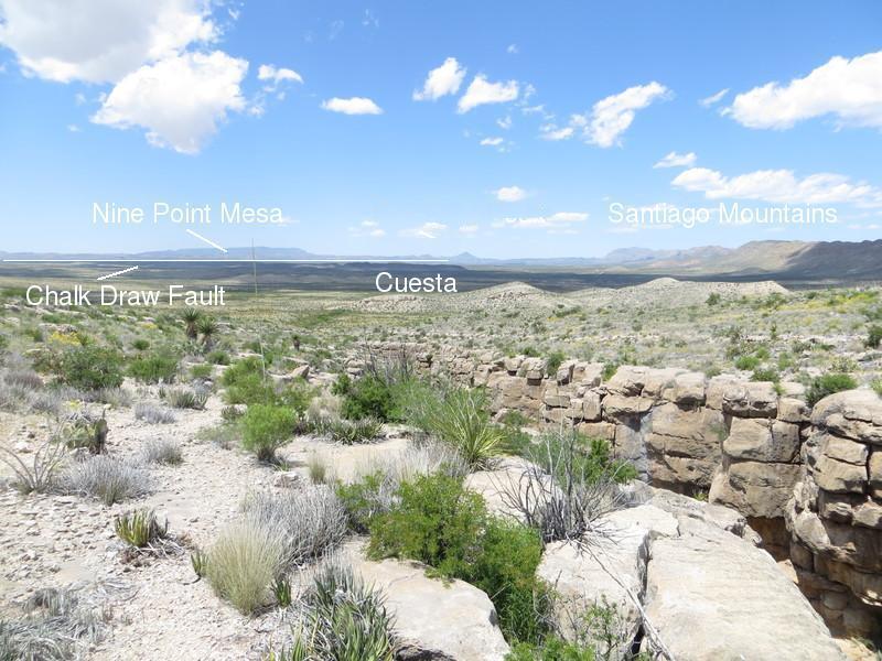
In this closeup you see a fault line marked. The USGS map does not extend to this area, because it is outside the park; however, the topography clearly indicates the Chalk Draw Fault continues to the northwest beyond Nine Point Mesa, and it has been mapped extending to the south and west of Santiago Peak. (Not in the picture, Santiago Peak is a 6535-foot igneous intrusion about 13 miles south of Marathon, Texas.) Note the scarp in the photo, which has been formed as those rocks have moved upward relative to the rocks in the graben. Also, it seems likely that the formations outcropping in the scarp within the park would also outcrop in the photo. The resistant bed would then be the Santa Elena Limestone with the Del Rio Clay and the Buda Formation above that. Closer to the foreground is an igneous intrusion of basaltic composition, likely a sill, which is a flat intrusion of magma that seeps between pre-existing bedding planes. Since that time erosion has exposed it. Basalt is an iron-rich rock whose magma is usually pretty "runny", making it an excellent type of magma to form a sill rather than a bulbous intrusion formed by more viscous magma. (Recall videos of basaltic lava flowing from the Kilauea Volcano on the big island of Hawaii.) The radiometric age of this particular intrusion is unknown as far as I know, but other like intrusions in the northern parts of the park have ages near 30 million years.
On this side of the graben you can spot a cuesta. The cuesta's steep face is roughly toward the camera, and it slopes away to the west on the other side toward the main road. According to the new USGS map, the cuesta exposes both the lower and upper members of the Boquillas Formation, as indicated in the closeup. The prominent ledge is possibly the upper limestone bed of the Ernst member, which contains fossils of the ammonoid Allocrioceras hazzardi. This is an index fossil, a fossil of a creature that lived over a wide area during a relatively short period of time and is thus useful for biostratigraphy: the use of fossils for the time correlation of sediments. An ammonoid was a cephalopod (such as the octopus and the squid) that looked a lot like the modern nautilus, except this creature was one of the uncoiled ammonoids called heteromorphs. When I was a physics professor at Texarkana College, my geology students found numerous heteromorph fossils in a Cretaceous formation called the Annona Chalk on field trips. (I was the only one with a geology degree and geological experience, so teaching this course fell to me.)
The sloping topography you follow as you gain altitude reflects the dip of the Santa Elena and other rocks in this part of the park. The slope of the cuesta does as well. This dip is due to a large-scale geologic structure called the Santiago Mountain-Sierra del Carmen monocline, which is a geological fold where beds have been bent from horizontal to sloping and back to horizontal. In other words, there is a sort of "kink" in the the beds. This monocline, like the one at Mesa de Anguila in the southwest part of the park, is due to crustal compression during the Laramide orogeny, a mountain-building event that occurred in the late Cretaceous and early Tertiary. The axis of the monocline extends from the north northwest to the south southeast on the eastern side of the park. The Santiago thrust fault mentioned above and to be discussed in more detail below was also a consequence of the Laramide orogeny.
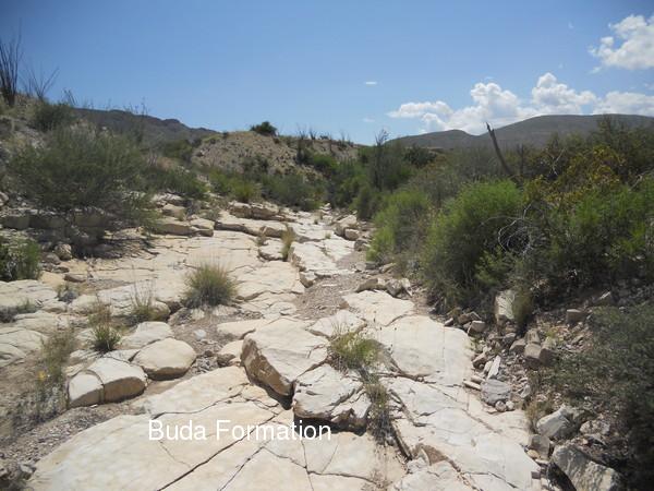
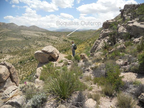
When you hike back down Devil's Den, you are going "down-dip" toward the cuesta in the photos above. In the down-dip direction you encounter progressively younger rocks. Hence as you hike back down Devil's Den, you leave the older Santa Elena, then the younger Buda Formation in the wash that the Den's waters empty into (photo below), and eventually view the even younger Boquillas Formation overlying the Buda and in the face of the cuesta in the distance. Farther down dip on the other side of the cuesta the Pen Formation appears. Eventually, beyond that to the west, you come across the Aguja Formation, which is generally younger than the Pen. This sequence of older to younger rock from east to west is thanks to the above-mentioned monocline.
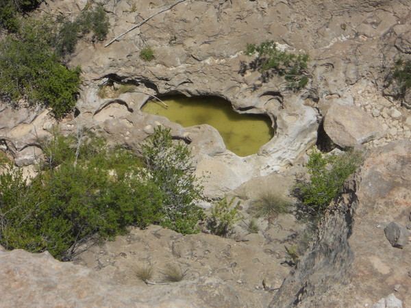
There are a number of tinajas in Devil's Den. Note the one in the following photo. You have to wonder about how useful a tinaja such as the one pictured is to wildlife. A prey species would be at great risk bottled up in a narrow canyon such as Devil's Den. The steep sides of this tinaja might be treacherous for any animal, predator or prey.
The next photo was taken in the upper reaches of Devil's Den. Note the steep walls and another tinaja.
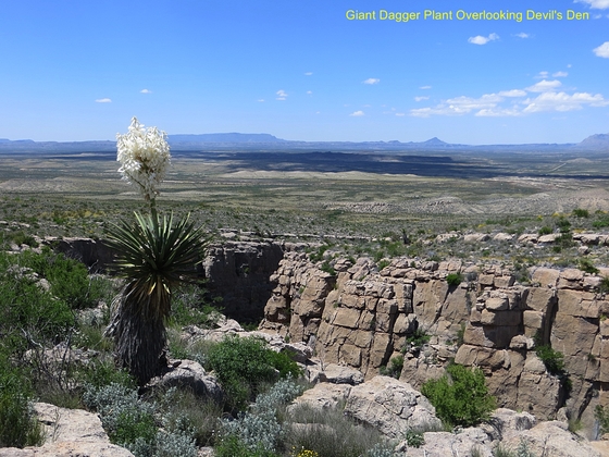
As you approach the eastern end of Devil's Den, you begin to come across more and more of the giant yuccas for which Dagger Mountain to the south and Dagger Flats were named. The following picture is of a couple of nice specimens in bloom.

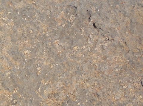
The Santa Elena is occasionally fossiliferous along the upper stretch of the canyon rim. Below is an example of a rock containing abundant fossil shells – not well preserved but likely clams and possibly some oysters. The largest fossils are about the size of a half dollar.
There are faults a-plenty at the eastern end of Devil's Den. The most noticeable is the one that is responsible for the escarpment at that end. The pictures below are of that feature. As you might suspect, the fault is down to the east, forming the cliff. The first picture is looking north and the second south. Note the small cliff of Boquillas Formation rocks exposed by erosion in the wash, which follows the fault up to the south toward Dagger Flat. The Boquillas is stratigraphically higher than the Santa Elena you are standing on – proof that the motion was down on that side. The fault line to the north is buried by debris for a while but, according to the new USGS map, re-emerges to the surface and joins the Santiago thrust fault.
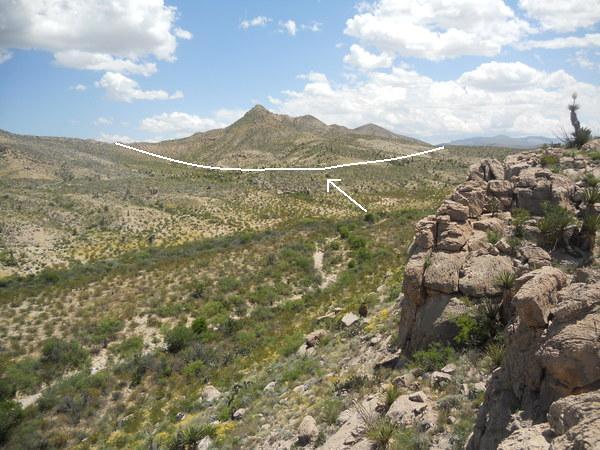
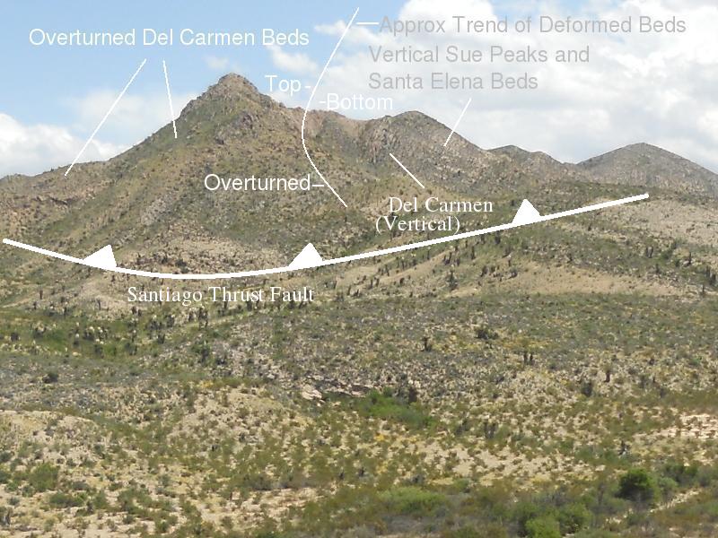
And, speaking of the Santiago thrust fault, which is also the one through which Dog Canyon cuts, it extends northeast to southwest along the ridge across the valley. The next photo shows the approximate location of the fault, and the one after that is a closeup of the rocks on the other side of the fault. The rocks on the camera side of the fault have been thrust under those on the opposite side, relatively speaking, as indicated by the "teeth" on the "cold front" style line, deforming and folding them to the point they have been turned over and are in some places stratigraphically upside down with older rocks on top of younger ones. In particular, along and on the other side of the ridge, the Glen Rose Formation (limestone, not in the picture) rests on the younger Del Carmen Limestone, which in turns rests on the still younger Sue Peaks Formation, which, finally, rests on the Santa Elena Limestone. Very roughly, the trend of deformation is indicated by the curved line in the closeup photo. All these formations are lower Cretaceous.
The Santiago thrust, which can also be seen at Persimmon Gap, is another feature of the Laramide mountain-building episode associated with the subduction of the Farallon Plate beneath the North American Plate. When this thrusting took place, all these rocks were well beneath the surface that existed at that time. No doubt thousands of feet of sediments have been removed from the geologic record in the upper Cretaceous and lower Tertiary since the time the fault was active. The truncation of vertical beds on the mountain obviously means the beds originally extended up into where there is just blue sky now, and there was more material above that.
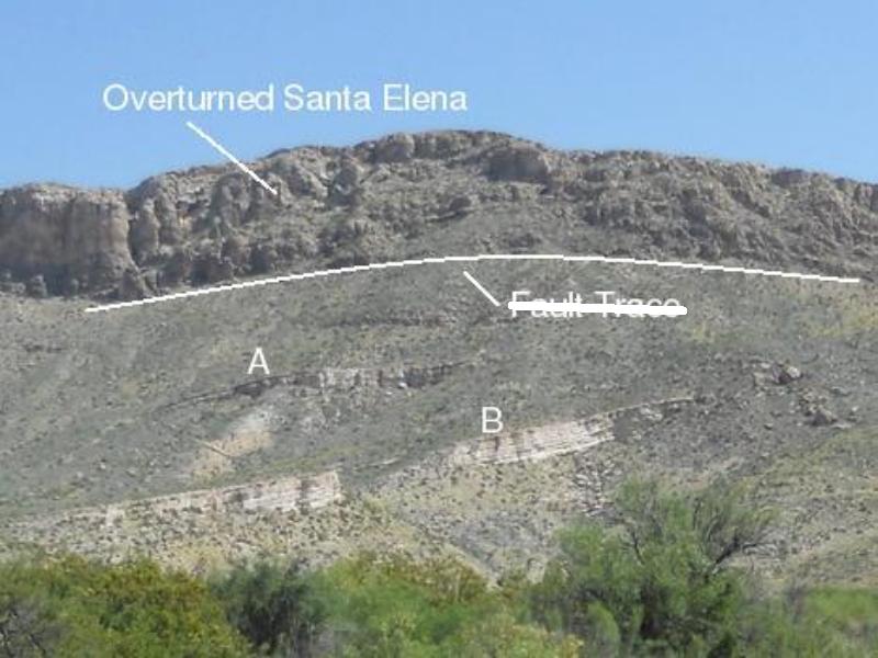
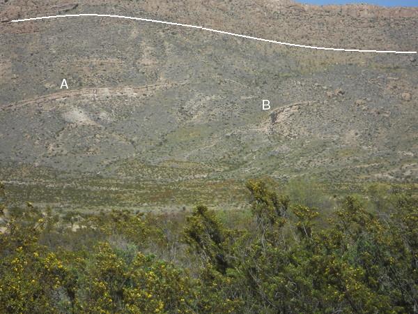
It's time to look at the messed up rock mentioned at the beginning of this field trip entry. First of all, you know something weird is up, because you see outcrops (A and B in the photos – appearance differences are due to changes in perspective) of the Buda Formation (limestone). The Buda is younger than the Santa Elena Limestone above it, so they have seemingly changed positions stratigraphically. The reason for this apparent contradiction is, once again, the Santiago Thrust Fault zone. (I originally thought there was a fault trace at the base of the cliff in the Santa Elena as shown below, but the new USGS map indicates the fault plays out from northwest to southeast and is not present here. The main fault is on the other side of the ridge.) The Santa Elena is overturned; the top of the formation is marked by the line in the photos. This is obvious if you follow the folding of the Santa Elena in Dog Canyon.
Beyond that, things are not clear to me, even with the new geologic map, and I've changed my mind several times (which, of course, means having to change the online field trips involved!) as the situation here is confusing. However, the advent of Google Earth has helped immensely, so here I go changing my mind again. Despite the appearance of outcrops A and B to be parallel, this is a trick of perspective. In fact, outcrop B trends downslope, whereas A is nearly perpendicular to the slope. I now believe A and B are the same bed of the Buda Limestone, a bed which strikes northwest and dips southwest. This makes sense, because if you look at the Buda on the west slope south of Dog Canyon, only one cliff-forming unit is seen, and this might be the bed forming outcrops A and B. Previously I thought A and B were the same bed, but that A was folded over B and was upside down. Now it appears both A and B are upside down, being the same bed.
 |
 |
On the other side of the ridge you have the Sue Peaks Formation, older than the Santa Elena, also overturned and resting on the Santa Elena. The even older beds of the Del Carmen Limestone are overturned and on top of the Sue Peaks. (See the Dog Canyon feature for more details and pictures.) Recall, this is what you also observe at the east end of Devil's Den. And, as was the case there, the relative motion along the fault is for the foreground rocks to be thrust under the rocks on the other side of the thrust fault.
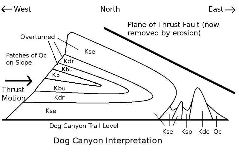
To try to clarify this obviously complex situation, I have created the following schematic for Dog Canyon, reproduced here. I think this interpretation is compatible with the new USGS map, except that since drawing it, it appears the beds on the west side are folded to the point they dip to the west. Also I can't vouch for the accuracy of the stratigraphic relations in the section between the normal Santa Elena at the base of the slope and the overturned Santa Elena at the top of the ridge. The units labeled are (older to younger) the Del Carmen Limestone(Kdc, where "K" is the geological symbol for the Cretaceous), the Sue Peaks Formation (Ksp), the Santa Elena Limestone (Kse), the Del Rio Clay (Kdr), the Buda Limestone (Kbu), the Boquillas Formation (Kb), and Quaternary colluvium (Qc). (The Quaternary is the most recent geologic period, beginning about 2.6 million years ago and continuing today. Colluvium consists of debris on hillsides deposited by a variety of processes.) Note how the thrust of younger rocks (Santa Elena et al) under older ones (the Glen Rose Limestone, not shown) has bent the rock beds over on top of themselves, such that the beds on the upper part of the west-facing slope are overturned.
Summing up, before our hike I had the mistaken notion that Devil's Den, unlike Dog Canyon, would be a nice hike without a lot of geology to look at. I was definitely wrong. I would very much like to spend more time in the Dog Canyon-Devil's Den area and enjoy the fascinating geology produced during a time when the crust here was subjected to immense tectonic forces.
BACKWARD to Lower Tornillo Creek
FORWARD to Cattail Falls
ALL THE WAY BACK to the Contents