If you want to examine the innards of a thrust fault, Dog Canyon is the place to go. The images seen here were mostly taken during June, 2007, on a relatively mild day for the northmost end of Big Bend National Park. However, "mild" is a relative term. The temperature was above 100 – for most of us this would be a "dog day" in Dog Canyon. Fortunately, Dog Canyon is only a stroll of a few miles along a level surface that trails downstream beside Nine Point Draw. You still want to take plenty of water. [The 2007 images have now been augmented with more taken in October, 2015, and this feature has been updated with the help of the new USGS map (Scientific Investigations Map 3142, 2011).]
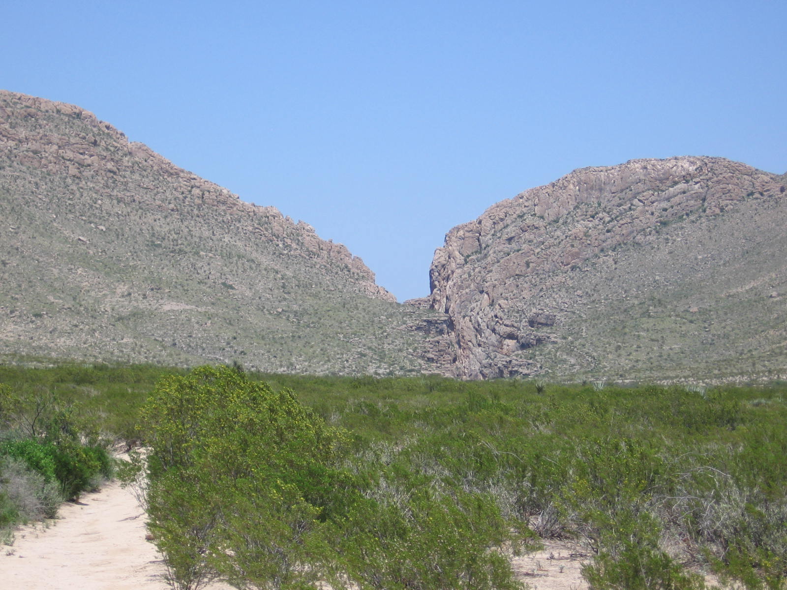
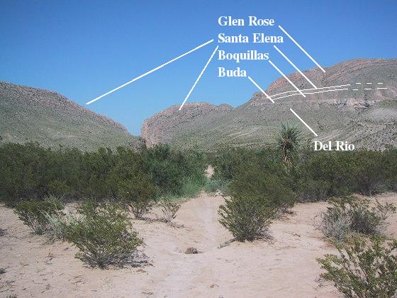
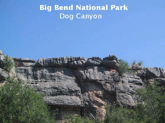
Below you see Dog Canyon in the distance, the notch marking the southern end of the Santiago Mountains that appears near the center of the image. This picture was taken roughly halfway down the trail. Already apparent are beds of sedimentary rock going in different directions, indicating something very unusual occurred here long ago. Note the plants. Those familiar with Big Bend will recognize they are greener than you would expect for June. My brother, Randy, and I took this hike after a particularly rainy spring in West Texas.
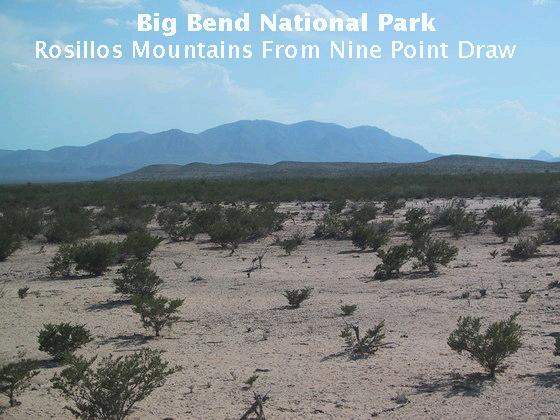
Setting the scene of the hike are the following couple of pictures taken on the route to Dog Canyon. The first is of the Rosillos Mountains to the southwest. In the middle distance, a mile or so away, are a series of low cuestas. These are due to the beds of the upper Cretaceous Pen Formation, mostly a limy and sandy clay, which dip gently to the north. Topping the cuestas, above the Pen, is Pleistocene alluvial (water deposited) material, according to the new USGS map. Cuestas like these are formed when weathering and erosion eat into the more exposed parts of dipping beds, creating relatively steep slopes, which then slowly retreat down-dip (north in this case) under the attack of mass-wasting processes; such as creep, slides, and rock falls; and water erosion. The Rosillos Mountains consist of intrusions of 32-million-year-old syenite magma, which is similar to granite, but richer in the alkali elements (sodium and potassium). (Update: This is a change from what I originally wrote, now following the new USGS map.) The highest point is Rosillos Peak at 5445 feet.
You are looking across a down-dropped block between here and the Rosillos Mountains called a graben, which was filled in with sediment, resulting in a flat plain. This particular graben is called the Chalk Draw Graben. On the left of the image, at the same image level as the cuestas, you can just make out the hills in front of the Rosillos Mountains. These hills are made of the same stuff as the mountains but have been down-faulted by the Chalk Draw Fault, which serves as the western boundary of the graben.
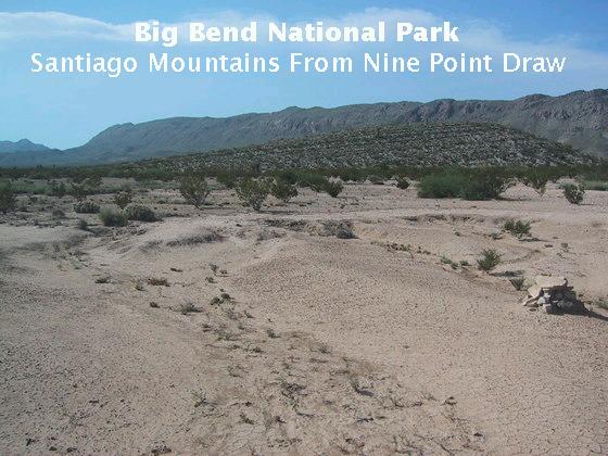
Turning around and looking to the north, you see the Santiago Mountains, through which Dog Canyon was cut. In the middle distance is a small cuesta, apparently consisting of the upper Cretaceous Boquillas Formation. The Boquillas consists of limestone and shale deposited in a shallow sea. The southern end of the Santiago Mountains is on the eastern boundary of the graben east of the Rosillos Mountains and consists of Cretaceous rocks riddled with faults.
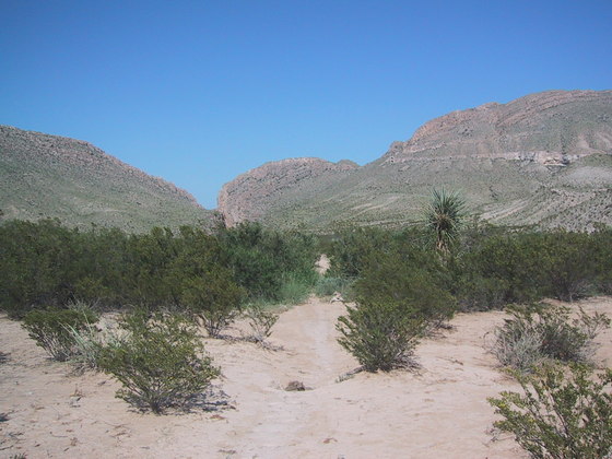
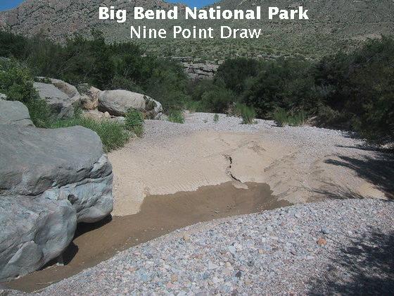
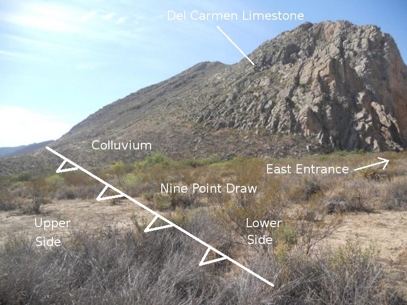
As you approach the canyon hiking up Nine Point Draw, there are some interesting fluvial features. I suspect you don't usually see water in the draw this time of year – the rainy season generally starts later in the summer. The water shown below was in a depression hollowed out during times of heavy stream flow, the last of which likely occurred sometime during the previous two months. Since my original take on this feature, I've changed my mind. I now think this may be a cut-and-fill type feature, where finer material was laid down in the depression when the flow decreased. Presumably, the large limestone block on the left, polished by thousands of years of water-carried clay, silt, and sand, was involved in forming this feature by diverting the flow. Water diverted to the right of the block, flowing in the direction away from the camera, was fast enough that the finer material was either never deposited or taken away, leaving gravel. The boulder may have also served to create a small waterfall responsible for the depression just behind it during heavy flow.
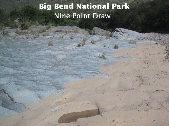
The scooped pattern in the limestone in the next image appears to be a ventifact, a feature created by the abrasive action of sand driven by the wind. However, the presence of these features in the limestone of the stream bed suggests they were created, at least to some extent, by the abrasion of water-driven sand. (However, I understand that recent geological work indicates wind action is a more important erosional force, for example, in canyons, than previously thought.) Additionally, once a small hollow forms in limestone, water that lingers there can facilitate the dissolution of the limestone, which is soluble in water that is even slightly acidic.
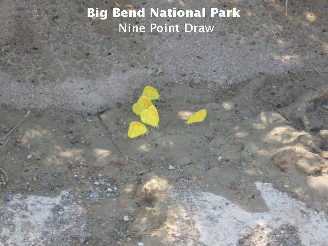
I've been told butterflies need minerals they can't get from nectar, so they obtain them from mud. Here are some of the little mudders doing just that, taking advantage of the recent rains. Other than being a type of sulphur butterfly, I don't know what species it is, but it may be a mimosa yellow, whose range includes southwestern Texas.
Back to Dog Canyon, the image below is the same one shown earlier, doctored with lines indicating the position of the faults. (These lines were originally based on the interpretation presented by Ross Maxwell in his book The Big Bend of the Rio Grande. I have now revised them just a bit using the new USGS map.) The higher of the two lines marks the trace of a thrust fault. Thrust faults are low angle faults where one block of rock has been shoved under another. The lower line marks the trace of another fault, not a thrust fault but with the Santa Elena Limestone moved up (on the far side of the fault) with respect to the upper Cretaceous Boquillas Formation. You know this because the Santa Elena is older than the Boquillas and they are at the same topographical level on either side of the fault. The dashed lines indicate where surface material covers the fault traces.
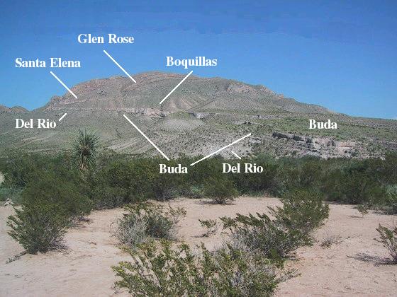
The cliff-forming Buda Limestone (pronounced "byoo-dah", not "Buddha" –the holy man never made it this far west) on the right (south) side of the canyon is younger than the Del Rio Formation (mostly claystone) on which it rests, so no problem here. Nor is there a problem with the Boquillas on top of the Buda. Nothing to worry about concerning the Boquillas and Santa Elena, as they have simply been juxtaposed by a vertical fault – the Santa Elena is not resting on the younger Boquillas. However, what's the older Glen Rose Limestone doing sitting above the younger Santa Elena? The thrust fault mentioned above is responsible for this apparent contradiction. The younger rocks have been shoved beneath the older ones. I have heard that so-called "young Earth creationists" reject the existence of thrust faults, since they are often responsible for older rock being emplaced over younger rock. These creationists would rather see older rock over younger rock as proof geologists can't tell how old rock formations are. A trip through Dog Canyon should put to rest all doubts that thrust faults exist. Note the stepped pattern in the Glen Rose. This is due to it being composed of alternating beds of weathering-resistant limestone and softer marl, which is essentially a dirty limestone.
Below you see the (west) entrance to Dog Canyon. As you enter you are struck by rocks falling on your head. Just kidding (or I hope so!). You are actually struck by the fact that the beds where you are standing are horizontal while those in the distance are vertical. (Being struck by a fact is usually less painful than being struck by a rock, unless, ironically enough, you are hard-headed.) A little observation reveals the beds are folded sharply upward in the distance. (See the line in the image below. My brother on the lower right helps set the scale.)
It was at about this point we became aware of an increasingly deafening roar approaching from the east. We had no idea what was going on. Big Bend is supposed to be this refuge from the assaults of civilization. It was only a few seconds until the source of the incredible noise made its presence. A military jet, flying low just above the canyon, flashed above our heads. The sound, reverberating between the canyon walls, was incredible. Now, I believe whole-heartedly that a ready military force is a necessity for the country. However, I don't think it likely that Dog Canyon is a target of al-Qaida or other enemies. Nor do I believe there is something about Big Bend National Park in general or Dog Canyon in particular that is vital to the training of military jet pilots. I really doubt this behavior would be tolerated in Yosemite. All our national parks should be respected. This is no way to treat a national park. (Much later after writing this I learned in Death Valley that Rainbow Canyon there is used occasionally for pilot training. Maybe I'm an old fogey, but I wish they would find other venues for such training.)
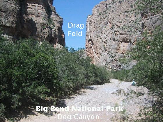
Getting back to geology, here's a closer view (looking upward at the nearly shear cliffs) of the fold, a drag fold created in a fault zone by friction when the rock on one side of a fault pulls on the rock on the opposite side as it is displaced along the fault. In this case there was a thrust fault, the Santiago thrust fault of Laramide age whose plane used to be above the rocks shown. It has been eroded away at this location. The Laramide tectonic event created geological folds and faults in Big Bend as well as throughout the North American Cordilleran. In the north and eastern reaches of the park this includes the Santiago-Sierra del Carmen monocline, which is a geological fold where beds have been bent from horizontal to sloping and back to horizontal, as well as the Santiago thrust fault.
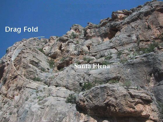
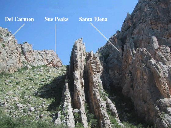
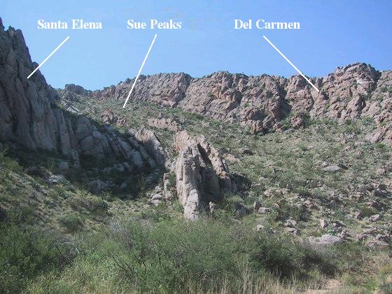
The image below was taken of the south side of the canyon just to the west of the fault zone. The next image was taken of the north side. You can see the folded beds belonging to the Santa Elena, Sue Peaks, and Del Carmen Formations. These rocks were shoved under those of the Glen Rose Limestone to the east of the fault zone during the Laramide mountain-building event. Note how the Sue Peaks has been eroded down due to it being less resistant than the other two formations.
Walk a little farther down the canyon and you come face to face with the plane of the fault. Well, not really, because the fault trace is buried under debris here. The USGS map locates the trace here, just to the east of the overturned beds of the Del Carmen Limestone, by extrapolating from north of here, where the fault is apparently exposed. The image below shows the approximate location of the fault, looking south at the east entrance to Dog Canyon. The line that looks like a cold front on a weather map is the geological symbol for marking the trace of a thrust fault. Here the rocks on the right have been shoved under those on the left (which aren't seen in outcrop in this image but are buried under the water-deposited alluvial sand, silt, and clay of Nine Point Draw.) The "teeth" on the thrust-fault symbol are on the upper fault block, that is, on the rocks above the fault plane.
I've tried to clarify the geology of the north side of Dog Canyon in the following schematic. A similar schematic could be made for the south side. The formation labels here are, in order of older to younger: Kdc (Del Carmen Limestone), Ksp (Sue Peaks Formation), Kse (Santa Elena Limestone), Kdr (Del Rio Clay), Kbu (Buda Limestone), and Kb (Boquillas Formation). The Qc stands for Quaternary colluvium. (The Quaternary is the most recent geologic period, beginning about 2.6 million years ago and continuing today. Colluvium consists of debris on hillsides deposited by a variety of processes.) Note how the thrust of younger rocks (Santa Elena et al) under older ones (the Glen Rose Limestone, not shown) has bent the rock beds over on top of themselves, such that the beds on the upper part of the west-facing slope are overturned.
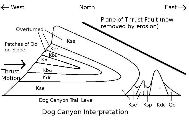
Since the Santa Elena is easy to identify and its folding easy to follow, I'm confident in that part of the schematic. Although the Sue Peaks and the Del Carmen are truncated here, they are continuous to the top of the ridge farther north according to the USGS map. I'm pretty sure I was able to identify the Del Rio and the Buda on the west slope north of Dog Canyon, but the Boquillas also outcrops there according to the USGS map. The map shows much of the slope just north of Dog Canyon is covered with colluvium, and it probably hides the Boquillas, the Buda, and the Del Rio. I could only see the Santa Elena on the sides of the canyon, although other units may appear well above the canyon floor. I drew the schematic as if they were present. I make no claims for the exactness of the schematic between the upper and lower limbs of the Santa Elena fold, but it does seem to be consistent with the USGS map.
You may wonder how rock as hard as limestone can be bent so severely. Young-earth creationists have argued that the rocks had to be soft, recently deposited by Noah's flood, when they were folded. However, floods don't deposit limestone. This claim also doesn't account for folded beds of igneous rock. At great depth under great pressure and elevated temperature, rocks can respond to stress by gradually bending. Even rock table tops supported at each end will gradually bend under their own weight over many decades.
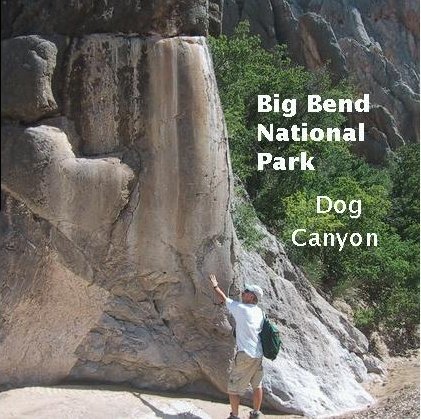
On the way out, we pause to examine the limestone sides of the canyon wall that have been smoothed by the abrasion of thousands of years of flash floods, rushing down Nine Point Draw and through the canyon. This particular polished surface is on the Del Carmen Limestone.
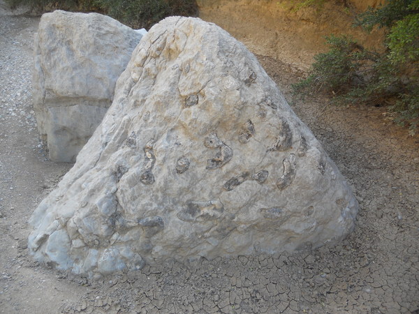
In the Santa Elena Canyon trip, I pointed out chert layers and nodules in Santa Elena Limestone boulders that had fallen from the canyon cliffs. Here in Dog Canyon is another example of this, with rounded, gray nodules riddling this particular boulder.
Another interesting feature formed by water is seen at the entrance to the canyon. Rainfall flows over the tops of the walls in places, resulting in a fluted design. As mentioned earlier, limestone is soluble in acid, and rain is slightly acidic (unless you live in New England, where the rain is so acidic the trees have to take Tums – well, I understand now that the acid rain there has been greatly mitigated).
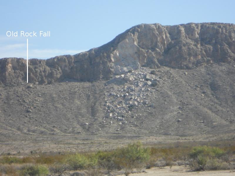
To the north of Dog Canyon, there is a major rockfall off the Santa Elena Limestone on the west side of the Santiago Mountains. This was described in an earlier field trip. From Nine Point Draw you can get a better view. Some of the boulders are as large as buildings. Note the much older rockfall to the left.
Finally, this is the view of the north side of the mountain south of Dog Canyon, as you make your way back to the trailhead. The cliff-forming part of the Buda Limestone extends from the lower right upward at a slight angle into the mountain. Above the Buda you have the Boquillas Formation and then a sliver of the Santa Elena Limestone truncated by a fault below and parallel to the thrust fault. The top of the mountain above the thrust fault is composed of the Glen Rose Limestone. One account says Dog Canyon was named by a traveler who found an ox-drawn cart protected by a dog. The owner of the oxen, in this account, was never found. Another account says that the canyon was long known as "Canon del Perro" (Dog Canyon in Spanish). Now that the USGS has published an updated map of the park, I am anxious to get back to Dog Canyon and explore some more.
FORWARD to Persimmon Gap
BACKWARD to Burro Pouroff
ALL THE WAY BACK to the Contents