The Rio Grande's Main Squeeze: Santa Elena Canyon
The story of Santa Elena Canyon is also the story of the Rio Grande itself. Geologically speaking, this is a rather young river. The establishment of the Rio Grande drainage system is partially responsible for the change from deposition to erosion in the park. Also playing a possible role is the decline in Basin and Range activity, which involved the creation of fault-block mountains (particularly noted on the east side of the park) due to activity on high-angle faults. The Basin and Range tectonism began about 25 million years ago in the park and had pretty much ended by two million years ago. As a result of the erosion resulting from the Rio Grande drainage system, you now have former depositional areas, such as Tornillo Graben, just to the east of the Chisos Mountains and occupied by thick deposits of sand and gravel, cut by arroyos and canyons such as Estufa Canyon. However, the most spectacular result of the advent of the Rio Grande are the canyons along its course: Mariscal Canyon, Boquillas Canyon, and the most dramatic canyon of all, Santa Elena.
When the Rio Grande drainage system evolved to a facsimile of what it is today is not completely settled; however, the bulk of evidence appears to support an earlier, 2.25 million year BCE, date. The theory is that at this time the northern ancestor of the river cut through a divide at the south end of the Hueco Bolson that lies to the northwest of the park and integrated with another river to the southeast, completing a channel to the Gulf of Mexico. This would mark the approximate time the river began to cut down through the Santa Elena Limestone, forming the canyons along its route.
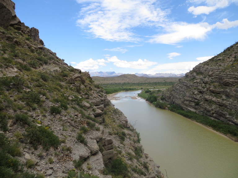
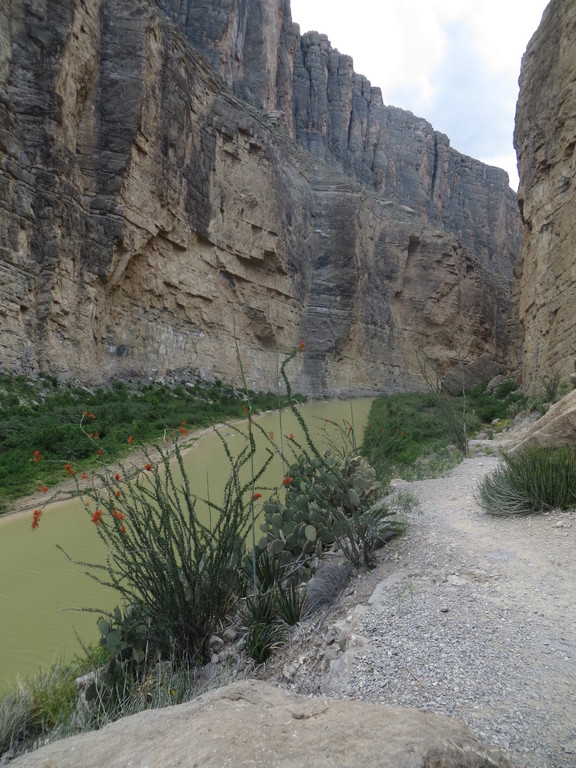
One may ask how it is possible for a river to cut such a deep (1500 feet) and narrow (down to 25 feet at one location) canyon. First, the river must become entrenched in its bed. This could possibly happen with rapid erosion in otherwise resistant rock. Limestone in an arid climate would seem to be ideal for entrenchment due to the fact it is soluble in water. This might mean the wet limestone bed of the river would be cut into rapidly (relatively speaking) while the dry banks would maintain themselves. Limestone in the river bed would be attacked by a combination of dissolution by chemical means and abrasion by sand and gravel carried by the swift currents. Once this process got going, a canyon like Santa Elena could be formed in one or two million years. It would only take an average erosion rate of about half a millimeter or less per year to do it.
Below is a photo taken on Mesa de Anguila that shows the canyon incision from above. Young-earth creationists would say the sediments that would become the limestone of the canyon were loose and easily eroded as the flood waters of Noah receded, carving out the canyon. There are two really big problems with this idea. One is that the rock is limestone, which is deposited slowly. Floods, Noah's included, don't deposit limestone. The other problem is that if the sheer cliffs of the canyon were of unconsolidated material, they would collapse. They would not be competent enough to support themselves. This support calls for extremely strong rock. In fact, were the canyon to deepen to the point where the rock on the bottom could no longer support that above it, the bottom of the cliff would explode outward. This sort of thing can, and has, happened in deep mines, in which the roof, sides, or even the floor of the mine explodes into the mine opening. Miners call this a "bump". Not exactly like your ordinary speed bumps! The receding water could not have cut down very far into unconsolidated sediment before the walls would slide or slump.
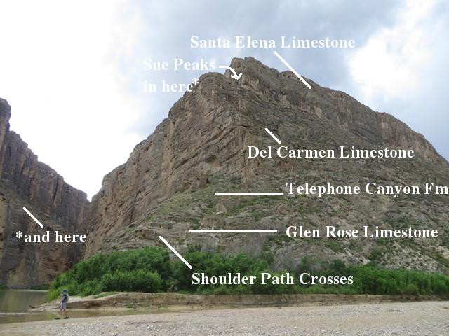
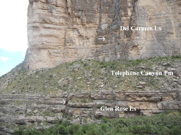
In the following picture you can see the shoulder of rock that you must cross over in order to get to the path that runs by the river. The rock units labeled are the Santa Elena Limestone, Sue Peaks Formation, Del Carmen Limestone, Telephone Canyon Formation, and Glen Rose Limestone, all of lower Cretaceous age. Limestone accumulates slowly in seas, or even lakes, mostly due to the deposition of shells and tests of marine life, but also due to chemical deposition. Since calcium carbonate, of which lime consists, is more soluble in cold than warm water, much limestone accumulates in warm, tropical seas. That was the case for the Santa Elena and Del Carmen. The Telephone Canyon Formation is also limey, consisting of alternating beds of limestone and marl, which is a sort of dirty limestone. The Glen Rose Limestone, below the Telephone Canyon, has a sort of "stairstep" look to it, as you can see in the second photo below.
It is unclear to me whether or not the Telephone Canyon overlies the Maxon Sandstone at this location. The new USGS map (Scientific Investigations Map 3142) does not divide them up, but maps the combination as "Ktm". I understand the Maxon is not found as a sandstone everywhere in the park, as it changes to more of a limestone unit from north to south. Geologists believe the terrestrial material that appears in the Telephone Canyon and Maxon is due to uplift and erosion north of Big Bend. The Del Carmen then marks the resumption of limestone marine shelf deposits. So, where is the Sue Peaks Formation? It is out of sight between the Del Carmen and the Santa Elena in the photo and consists of beds of limestone and shale. When all of these sediments were deposited, Big Bend was part of a shallow, warm sea (and, in fact, was located close to the equator due to continental drift.)
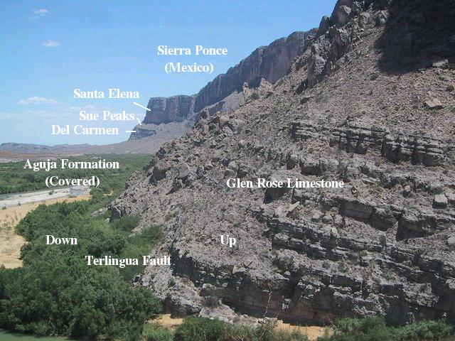
The canyon might be longer than it is were it not for the Terlingua Fault, which is (photo below) responsible for the dramatic northeastern scarp of Sierra Ponce on the Mexican side and Mesa de Anguila on the Texas side. At the mouth of the canyon the rock on the left (northeast) in the photo was dropped about 3000 feet compared to that on the right. The throw gets even larger in Mexico, to around 4300 feet. At the canyon mouth, the fault lowers the upper Cretaceous Aguja Formation, which mostly lies beneath relatively recent sediment along the river (but there are some outcrops), down to the topographic level of the Glen Rose Limestone. Note how the resistant beds of the Santa Elena and Del Carmen form cliffs whereas the less resistant Sue Peaks forms slopes.
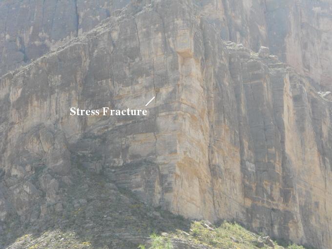
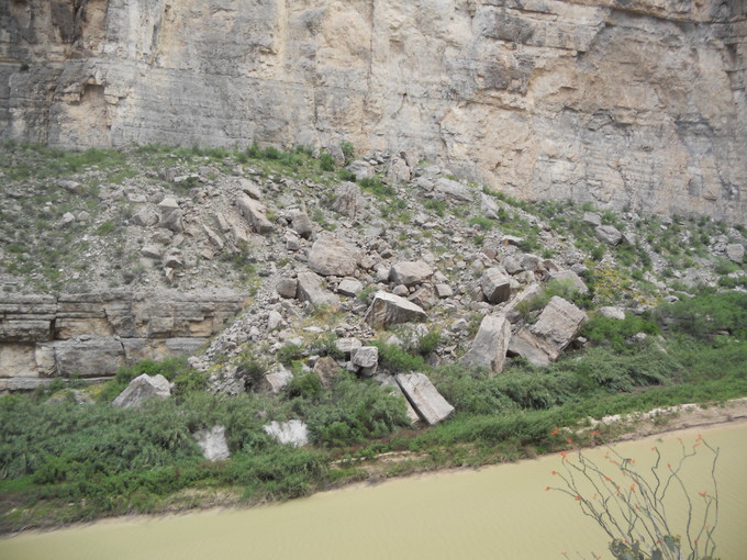
The Basin-and-Range era Terlingua Fault is right at the base of the fault scarp on the Texas side, indicating that the cliff here has not receded much since the fault was formed. (It might be appropriate to mention at this point that the 3000-foot offset did not occur all at once!) Nevertheless, it is clear that the scarp is slowly receding. (See the virtual field trip Maxwell Scenic Highway.) At the same time the canyon is very slowly widening. In the following couple of pictures you see first a stress fracture in the wall (Del Carmen Limestone) of the scarp. If that column of rock comes down all at once, it will be quite a spectacle (hopefully from a safe distance). The second picture is of a small rock fall.
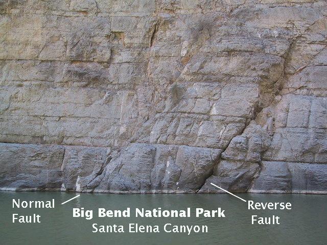
In addition to the major Terlingua Fault, there are numerous smaller faults that parallel it and can be seen in the canyon walls. In the photo that follows you can make out a small normal fault cutting through the Glen Rose and Del Carmen limestones but disappearing under the debris covering the Telephone Canyon Formation. In a normal fault the hanging wall of the fault (on the left here, to the northeast as indicated by the arrows) moves down with respect to the foot wall. I understand these terms came from men mining ores found in some fault zones. They stood on the "foot wall" and hung their lanterns on the "hanging wall".
Farther up the canyon you can see the following pair of faults, a normal fault on the left and a reverse fault on the right. A normal fault, as described above, occurs where the block above the fault plane slips down with respect to the block under the fault plane. A reverse fault is just the - ahem - reverse of this. A normal fault is created by tension in the crust (or, actually, less compression in one direction than in the other) and is associated with crustal distension. However, a reverse fault is thought to be created by compression and is associated with crustal shortening. How come you see both types of fault together here?
Since the fault planes are parallel, it is unlikely they were created by two separate events. Most likely the Basin and Range crustal extension that created the (normal) Terlingua Fault also created all the faults seen below. It's just that block to the right of the reverse fault slipped down relative to the block to the left, making it appear to be a compressional feature. Thus, the reverse fault is due to an episode of random motion in an otherwise extensional process.
The canyon trail is indeed awe inspiring. Sheer walls of 1500 feet rise above the river, placid when this photo was taken. With the use of the Rio Grande for drinking water and agriculture, you have to wonder what the future of the canyon will be (geological future, that is). It would appear that the rate of erosion would be reduced due to the reduced flow. On the other hand, there is little topographic relief between the river bed in the canyon and the surface of the land on the other side of the Terlingua Fault. Since fault movement apparently ceased at about the same time the Rio Grande began cutting into the Santa Elena Limestone, was there a waterfall where the river reached the scarp? Or was the topographic ground level on northeast side of the fault always close to that of the bed of the canyon? In that case the erosion of the ground level may have kept up with that of the bed of the canyon. The mouth of the canyon may then have been similar to how it appears today, except the fault scarp started out rather low but kept growing higher and higher as erosion went to work on both on the canyon bed and the less resistant material northeast of the canyon. There are other scenarios you can come up with. What would you have seen here, say, 500,000 years ago?
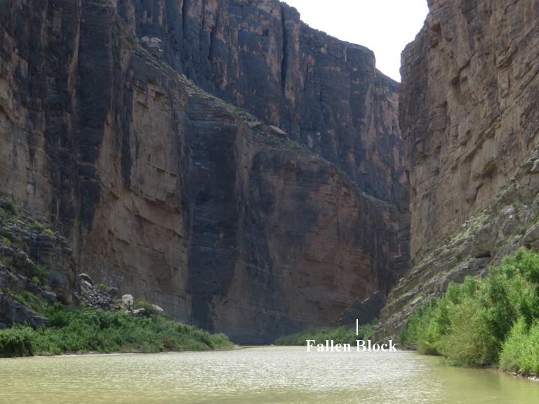
Speaking of erosional forces slowly widening the canyon, the picture below shows a large block that has fallen from somewhere on the canyon wall. Not too far beyond this block, the river trail ends. Note the desert varnish on the canyon walls.
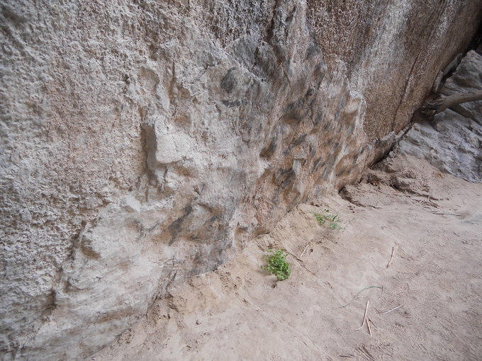
This block could be of either Del Carmen or Santa Elena Limestone. The interesing thing about this block is that it records what has occurred along a bedding plane. In the following photo you see what appears to be what is left of a layer of clay. The "pockets" in the clay look to me (I'm no expert, mind you!) like the scour marks I've seen in other sedimentary units in Arkansas. If so, that would mean you are looking at the top of a bed in this photo. Experienced geologists can use features like this to determine if a bed is right-side up or overturned. When folding is severe, you can get a significant amount of overturned beds. Of course, no folding here, just an exposure due to a rock fall, so there is little geological interest in whether this is the top or bottom of a bed.
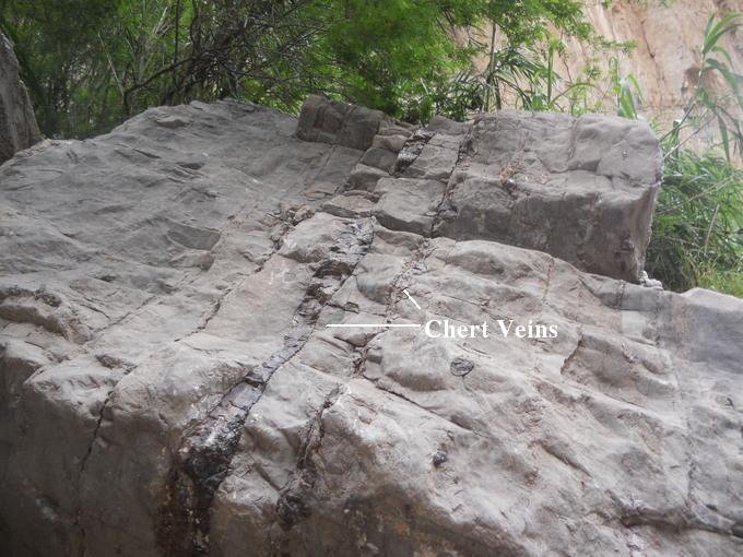
Perhaps somewhat more interesting is another block beside this one. Note the vein in the limestone. It is a vein of chert, a variety of quartz. This may consist of the shells of organisms, such as radiolarians and diatoms, that build their shells out of silica. Why it is a vein, I don't know (and neither, apparently, do geologists - there are at least a couple of ideas). Maybe there was a time when silica-shell builders were predominant and a silica ooze formed on the floor of the sea, or maybe it is the result of a diagenetic process, which is a change in the sediment after it was deposited, for example by an accumulation of chert over time from fluids rich in silica. The chert looks "concretionary" to me, so I favor the latter view. The presence of chert may mean this rock is of Del Carmen Limestone, as that unit is known to have chert layers and nodules
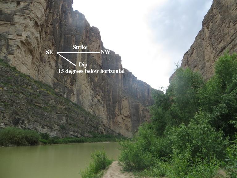
An observant person will note that the rocks dip up-canyon. That is, as you proceed up the river on the path, you are next to younger and younger rocks. In the following picture see how the Telephone Canyon Formation disappears upstream due to its dip. You are looking to the west-southwest when looking up-canyon, and the rocks have perhaps a 15° dip to the southwest (not quite parallel to the canyon walls) and a strike that runs northwest to southeast. (To find the strike of a bed, place a ruler on it such that it is horizontal. The compass direction of the ruler is the strike.) This strike and dip orientation holds on both Mesa de Anguila and Sierra Ponce and is due to a large monoclinal fold resulting from the Laramide mountain-building episode. Assuming the monocline dates to the same time as the related Terlingua uplift and Terlingua monocline to the north, it was formed sometime between 70 and 50 million years ago.
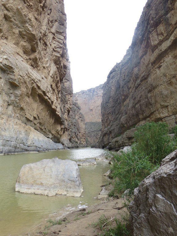
Now, for a sort of artsy turn in the field trip, here is the view at the end of the trail. Swimming or boating hereafter. At this point you are next to the Del Carmen Limestone; the Telephone Canyon is below ground level. The trail itself is on material, mostly sand, accumulated as the river waters slowed. Since the sand appears to accumulate at about the point the top of the Telephone Canyon Formation reaches the level of the river, there may be some connection here. There does seem to be a narrowing of the river (caveat: I made no measurements) at this point, so it is possible this is the reason for the sediment deposition. However, there is also a bend in the river about here, so that may be important also. At the river bend in the distance, you can see the Del Carmen, Sue Peaks, and Santa Elena rock stack.
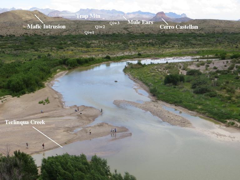
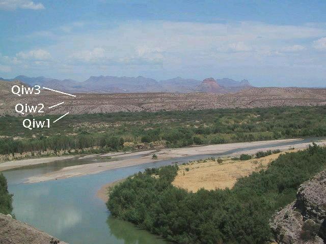
On your way out of the canyon, looking east, you can make out terraces of the Rio Grande, labeled as they are in the USGS map. Also in the picture is an intrusion of mafic magma. The word "mafic" is a combination of "magnesium" and "ferric/ferrous" (iron), indicating the two generally predominant metals in the magma. Most likely this is a basaltic intrusion like many others found in the park. The numbers, 1-3, refer to the age of the river deposits comprising the terraces: youngest, older, and oldest, respectively. The deposits consist largely of gravel, sand, and silt, well-rounded by the action of water. The tops of these terraces correspond to former flood plains of the river. Erosion has left these depositional remnants isolated, and, of course, will eventually remove them altogether.
One last picture shows pretty much the same view as above but several years earlier. Note the differences that have occurred. For one thing the trees and brush on the Mexican side have greatly diminished, but the major geological change is in the river - ever forming and reforming itself. What seems to us humans as permanence, is but a tick of the geologic clock.
BACKWARD to Cattail Falls
FORWARD to TBD
ALL THE WAY BACK to the Contents