How to Drown in the Desert During a Drought: The Ernst Tinaja
Tinajas are hollows in bedrock along stream beds where water can collect. Even when the stream is dry – the usual case in the Chihuahuan Desert – there may be life-saving water in the tinaja for wild animals and travelers. When the water level falls during a prolonged dry spell, however, a deep tinaja, like the Ernst, can be a deadly trap when an animal that accidentally falls in cannot get out. Apparently, at least one human (and possibly more) have drowned here.
The Ernst Tinaja is a large tinaja along a dry creek bed that cuts through Cuesta Carlota. A cuesta is a ridge with a gentle slope on one side and a steep slope on the other. They are often formed where dipping sedimentary rocks are cut by normal faults. In the case of Cuesta Carlota, a normal fault runs along the eastern side of the north-south trending cuesta, making the eastern side steep, while the opposite side dips gently to the west. Later you will see the dipping rock the cuesta consists of.
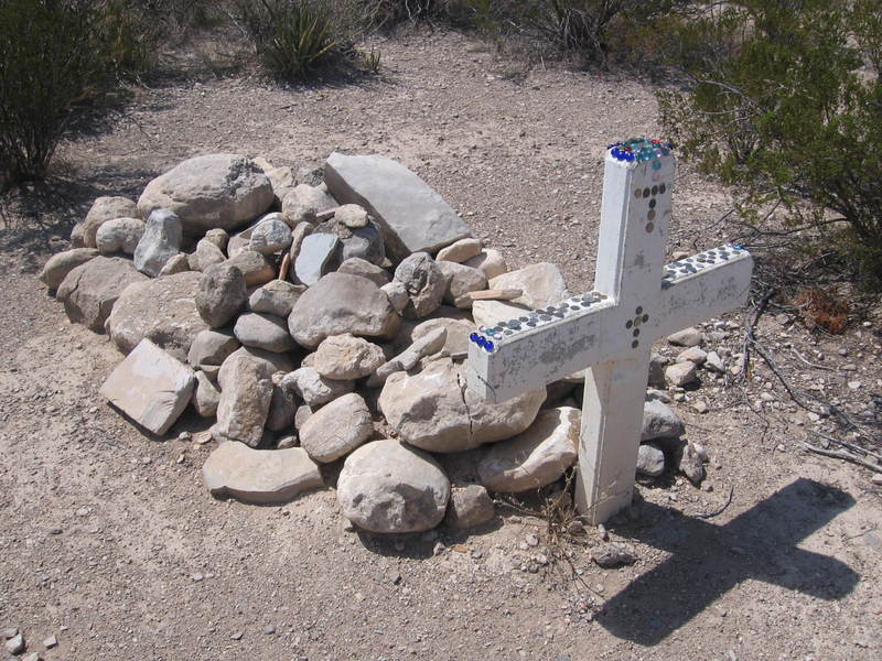
To get to the wash that leads up to the tinaja, you travel north on the Old Ore Road in the eastern area of the park, which requires a high-clearance vehicle (or a horse and wagon). Eventually, you will pass an old grave site, that of a young man of 26 named Juan de Leon. Juan's death is one of the unsolved mysteries of Big Bend's past.
Quoting the Park Service's website:
What happened on July 19, 1932, is unclear. What is known is that Juan de Leon was shot and killed while riding his horse. His body was not found for several days, and was so decomposed from the hot July sun that he was buried where he fell.
There are a number of accounts of how de Leon was murdered. According to his family, the gunshot came from a low-lying hill and Juan was left for dead next to the road. The story goes that the mule was startled from the gunshot and ran back to Chata's store. The saddle was covered with blood.
The grave is apparently tended to, although the Park Service discourages it. In fact, there are many other graves in Big Bend National Park, and only one receives park maintenance. This is probably an area where the Service needs to rethink its policy. These people died too recently for their graves to be considered mere archaeological artifacts. Perhaps letting those who care tend to this grave would allow the inscription on the cross, E. P. D. (En Paz Descanse - Rest In Peace) ring true.
After the sobering experience of viewing the grave of a wrongly killed young man, the trip up Old Ore Road to the Ernst Tinaja trailhead is a bit more subdued. You might even be more subdued if you think of the fate of Max Ernst, after whom the tinaja and Ernst Basin to the east were named. He was serving as Justice of the Peace when he was shot in the back while traveling on the Old Ore Road. Unlike Juan, he was found alive but died a day later. His murder was never solved either.
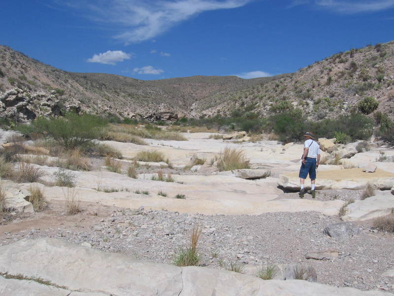
Finally on the trail, you hike up the wash to the tinaja through alluvial deposits, laid down over thousands of years by occasional flash floods. These floods also will erode what they have deposited. For example, examine the interesting cross section displaid below, cut by flash floods as the channel of the wash has changed course.
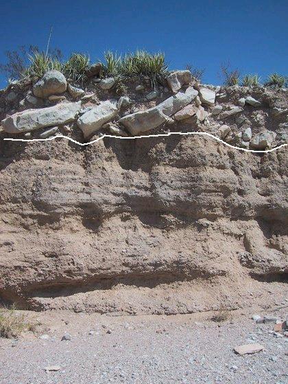
The layering shows the sediment was deposited in water. This sediment is likely the "QTog" on the geological map of Ross Maxwell (geologist and first park supervisor), described by him as consolidated terrace, pediment, and valley fill deposits of uncertain age, except that they are relatively recent (geologically speaking).
On the new USGS map of the park (Scientific Investigations Map 3142, 2011), the deposits along the wash are identified as either "Qya", late Pleistocene to Holocene alluvial deposits, or "Ta", basin-fill deposits of Miocene age. At this location you are looking at the Qya deposits on the south side of the wash. What is particularly interesting in this photo are the slabs of limestone, either the Buda or Boquillas Limestone of upper Cretaceous age. (The Cretaceous was the last geological period in which the dinosaurs lived, and limestone is a rock consisting largely of calcium carbonate - a refined version is called "Tums" - and is deposited typically in rather shallow, tropical seas.)
How did these slabs of limestone end up on top of the alluvium? Obviously, the alluvium was deposited first, but the limestone pieces are 100 million years older, so the limestone itself could not have been stratigraphically above the alluvium originally; they had to have been moved there by water or by mass wasting, which includes such things as surface creep, landslides, and rock falls. Imagine a stream alternately eroding into a hillside composed of limestone and depositing sand and gravel as its channel changed from time to time. With an unstable slope above a deposit of alluvium, you could well get blocks of rock deposited on top of the alluvium by mass-wasting processes. In this scenario, the uneven surface marked by the white line would be the erosional surface of the alluvium on which the blocks fell. Desert winds have likely removed a lot of the loose material on and around the larger rocks such that they presently act as a sort of a desert pavement. (Right now, that's the best explanation I got, folks.)
Well, in retrospect I can think of another possibility. What if there were a really violent flash flood at some point that was able to move even large rocks. Later erosional processes exposed the transported rocks on the sediment where they came to rest. Vioent flash floods are not that uncommon in Big Bend.
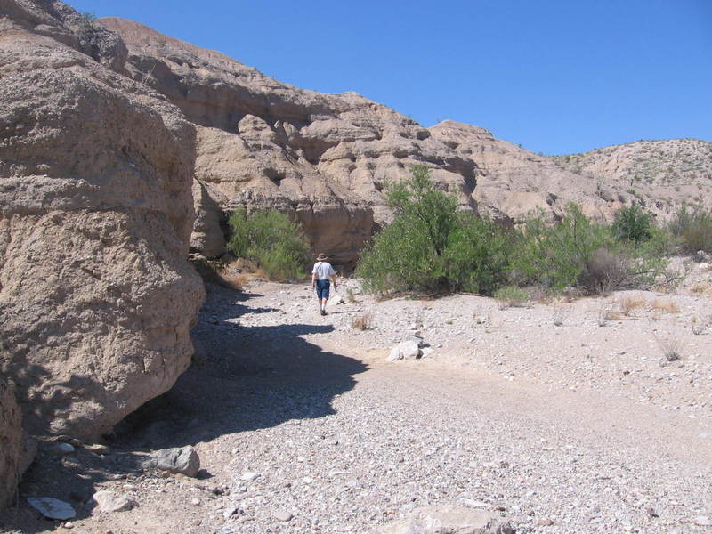
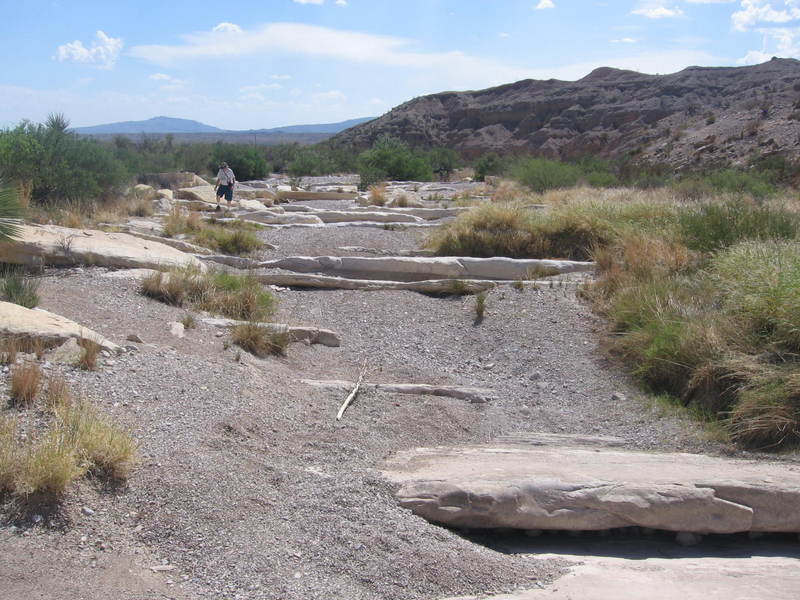
At the start of the hike you walk up the wash through well-exposed Ta basin-fill deposits. These correlate with the deposits seen in the lower reaches of Estufa Canyon and in much of the rest of the eastern side of the Estufa bolson to the west, a bolson beinga flat-floored desert depression. The bedding planes and the well-rounded clasts (geological term for the fragments that make up a rock) of clay, sand, and gravel size indicate this sediment was deposited by running water. No net deposition is occurring now, however, so the geological environment has transitioned from net depositional to net erosional over the past few million years.
The presence of the Miocene basin-fill deposits on top of the upper Cretaceous limestones you will encounter farther up the wash means there are tens of millions of years of missing geological history here. In geological terms this is an angular unconformity. Missing are the volcanic and sedimentary rocks found to the west in the park, meaning these rocks were either never here or were worn away. The absence of igneous intrusions suggests volcanic rocks were never here, but the sediments may have been worn away due to the uplift on this side of the park. Cuesta Carlota is the western-most uplifted block on the southwest margin of the uplifted blocks. However, other blocks have faults on both the east and west, but Carlota only has the eastern-side fault as far as the geolgical map goes. This implies the Cretaceous rocks found on the cuesta dip to the west unfaulted under the Miocene and Quaternary sediments of the Estufa bolson.
In the image below, looking east, you see the 100 million-year-old Buda Limestone (pronounced "byoo-dah") in the bed of the wash. Or, it looked like the Buda to me. However, the appearance of the limestones in the park can change quite a bit from one place to another, and the USGS map shows this to be the Ernst member of the Boquillas Formation, which rests on top of the Buda. According to the map, the Buda outcrops farther up the drainage. The Ernst is largely thin-bedded limestone, marl (a sort of dirty limestone), and shale. The rather thick limestone beds here fooled me. (On the other hand, if this is the Buda, then the Ernst is covered by sediment here and does not crop out. However, I'm going with the experts and calling this the Ernst member of the Boquillas Formation.) The pattern you see is due to the fact the limestone beds are not horizontal. Note how the rock in the bed of the wash has been scoured clean. The rock on the sides has been scoured, but not as much. Higher up on either side of the wash, where the waters don't reach, the Ernst is covered with erosional debris.
Now, looking back toward the west, you can make out the tilt of the beds of the basin-fill deposits of Miocene age on the ridge in the background. All the deposits on Cuesta Carlota have been tilted to the west as far as I could tell, meaning the tilting, and thus the faulting, had to have occurred after these sediments were deposited. That would mean the fault on the east side of Cuesta Carlota dates to the Basin and Range crustal extension, which began in the Miocene and continues today across much of the west between the Rockies and the Sierra Nevadas, although there is no known evidence of activity in the park during the past two million years.
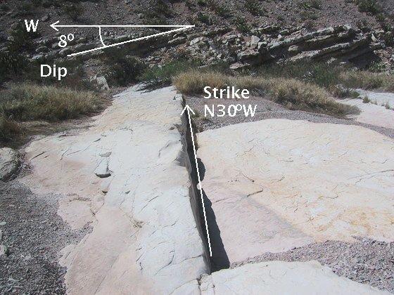
Cuesta Carlota exists because the beds of sedimentary rock that it consists of dip gently to the west from a fault on the east. In the following image you can see that the beds of Ernst Limestone at this location dip to the west at an angle of about 8°. Note the trend of the beds along the surface of the ground is about 30° west of north. This is called the strike of the beds. The strike is defined as the line created by cutting the surface of a bed by a horizontal surface. In other words, if you place a ruler on the surface of a bed such that it is horizontal, the direction of the ruler defines the strike. The dip of a bed is defined as the direction of steepest descent. The angle of the descent is the amount of dip. Now, the bed in the image below does not dip exactly to the west, because dip is always perpendicular to strike. The dip, to be perfectly accurate, is not 8° west, but 8° at 30° south of west. However, since the dip is always perpendicular to the strike, it is only necessary to say which side of the strike the dip is on. Cuesta Carlota's trend is determined by the strike of the sedimentary beds of which it consists. How steeply it slopes is determined to some extent by the dip of these beds.
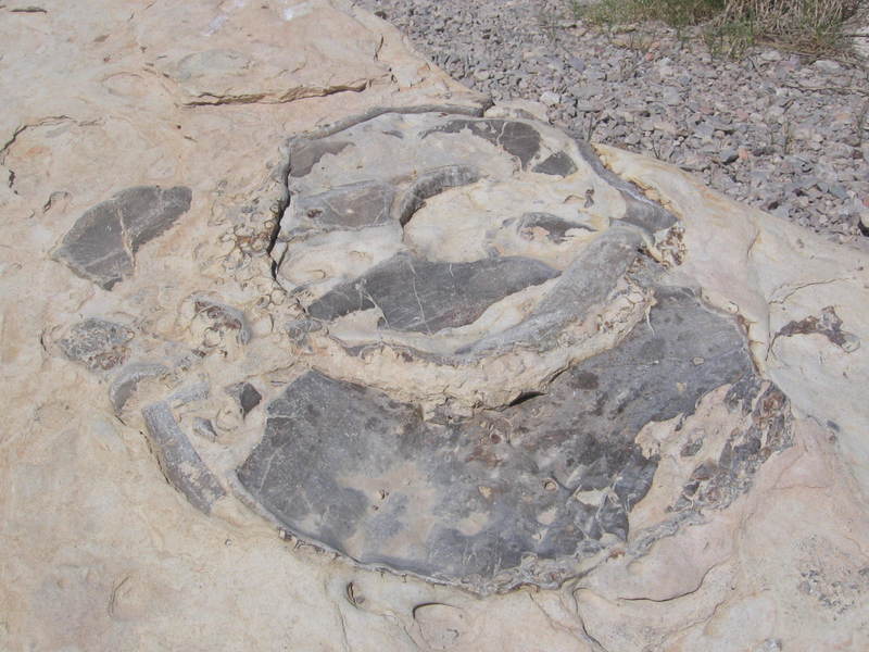
Few fossil remains grace the limestone, but the following picture appears to be of an ammonite – a cephalopod which looks quite a bit like the modern Nautilus. The USGS work mentioned above notes that such fossils are common in the Boquillas Formation.
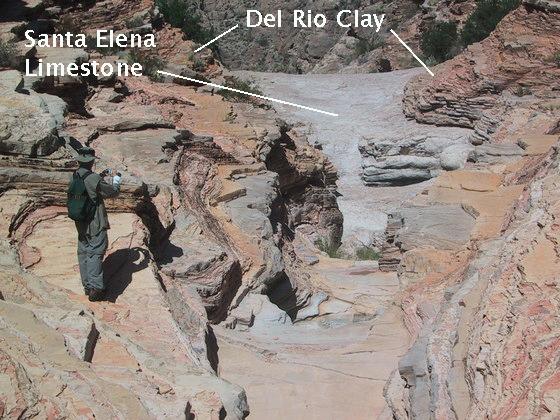
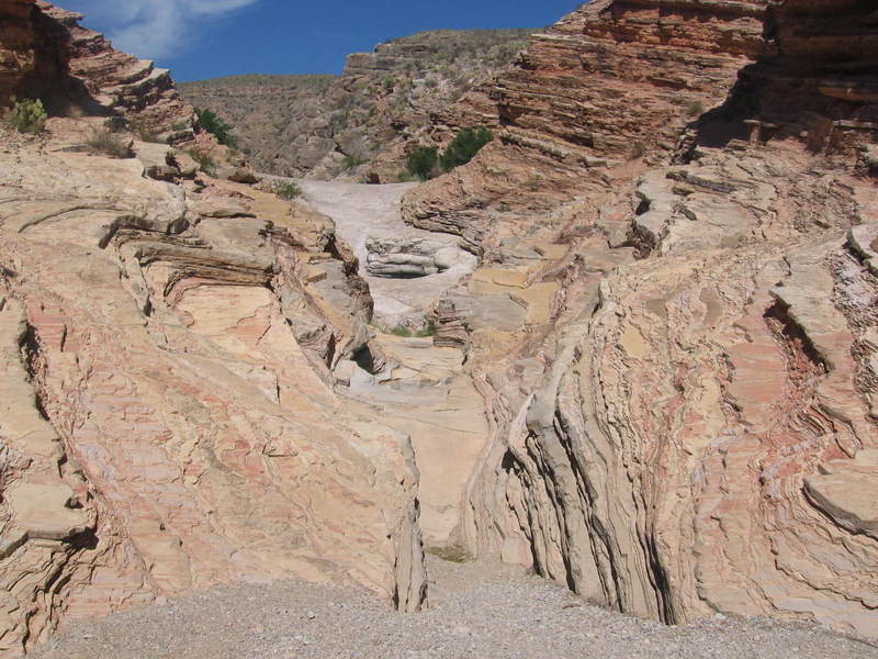
As you get close to the tinaja, the rocks get a bit op-artish. What you see here is my brother, Randy, taking a picture of the approach to the tinaja. The thin-bedded orangish rock is the Del Rio Clay, which lies stratigraphically just below the Buda Limestone and is also upper Cretaceous in age. The massive white rock below the Del Rio is the Santa Elena Limestone. Since the type of sedimentation changes so abruptly at the contact between the Del Rio and the Santa Elena, I originally thought there had to be a time lapse between the deposition of these two units called an unconformity. However, the recent USGS work makes no mention of an unconformity here. If this is the case, the Santa Elena was not exposed to the air and erosion, and the contact marks a geologically sudden change in deposition from largely marine lime to clay derived from the land. Since the Del Rio is thicker in the northern and western areas of the park, likely the source of sediment was to the north and west. The orangish color of the Del Rio is due to the presence of limonite, a combination of iron hydroxide minerals.
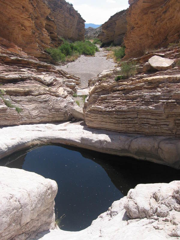
The tinaja is about the size of a small swimming pool. The water is cold, clear, and inviting. I was tempted to take a dip, but, covered with sunscreen, I figured that would not be the right thing to do environmentally, so I dismissed the idea out of hand. Even were it not for sunscreen, my body certainly was covered with nasty stuff after a hike. After all, many animals depend on this water for their survival. How would you like to drink water someone had just bathed in? (Actually, our dog would be happy to.)
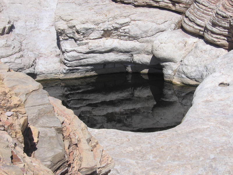
This next picture features Randy looking down at the tinaja and taking photos. This, amazingly enough, is the only photo of the myriad we took that indicates the scale of the tinaja. (Other than those containing me, which won't get past censorship.) The bedding of the Del Rio Clay, composed of shale, is striking. As you can see, it consists of mostly thin beds of shale that extend indefinitely in all directions. This implies a periodic supply of sediment to the shallow sea that existed here at the time of deposition. For example, since this area was in a tropical latitude when this sediment was deposited, the beds could record the wet/dry season cycle, and you could count the passage of time like counting tree rings.
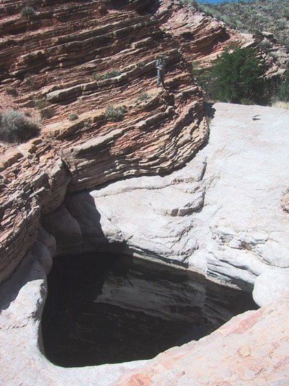
In the following image note the small hole to the right of the tinaja. This could be a clue to the formation of the tinaja. Structures similar to the Chihuahuan desert tinajas are seen in mountain streams I am familiar with in the Sierra Nevadas, for example. Once you get a small depression, sand and gravel can settle in it. When water flows in the usually dry stream bed, the water agitates this sediment, which can then act as an abrasive to wear a deeper depression. As thousands of years go by, this continued action can create a tinaja, especially where conditions are favorable for the depression's growth into a deep hole. My brother and I have seen depressions on their way to becoming tinajas in other parts of the park where the Santa Elena Limestone is on the surface. Massive limestone, like the Santa Elena, should be excellent material for tinaja formation due to the lack of bedding planes to serve as zones of weakness, diverting the erosion to the side rather than down, which would create a channel rather than a hole. In the Sierra Nevadas, the deep holes are in massive granitic rocks. The difference there, for one thing, is the fact that the streams are rarely dry in the Sierra Nevadas.
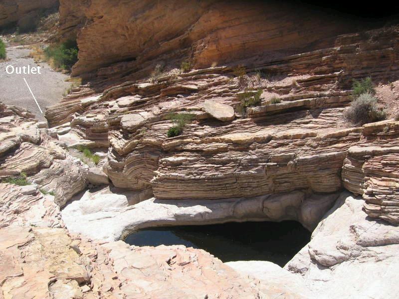
Why did the tinaja form here? Like a similar tinaja not far from here, the Carlota Tinaja, the Ernst Tinaja is at the boundary between thinner and more massive beds. Unlike the Carlota, it is at the summit of a local high in an otherwise downhill, east to west, drainage. This local high would slow the drainage, and that might be a clue. The formation of the tinaja would likely slow the flow even more and may be responsible for the narrow outlet in the photo below. Or, it could be the other way around. A bit of a remnant dam of the Del Rio Clay could produce turbulence in the water flow, leading to the formation and deepening of the tinaja. The presence of the dam might be due to water slowing down as a result of the local topographic high, reducing its erosive power.
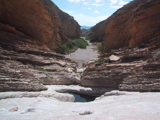
In the following image you see the outlet from the tinaja looking east. The rock on the side of the drainage in the distance on the right is the Buda Limestone. Note the Del Rio beds are parallel to the uneven surface of the Santa Elena. Beds of sedimentary rock are laid down horizontally, not at an angle. Hence the surface of the Santa Elena had to be horizonatal when the Del Rio was deposited. That means the uneven surface had to be formed after the deposition of the Del Rio. When I originally wrote up this trip I speculated that there might be a fault involved in forming such a surface. The USGS map shows a secondary fault splaying off the fault on the east side of Carlota Cuesta that extends toward this area, which supports this speculation. The same forces that created the fault may have uplifted the rock here creating what is now an uneven surface. The tinaja is on a local high point (due to uplift along a buried portion of this fault?). We were constrained by time and weren't able to follow the drainage up to Ernst Basin during this hike, but I would like to do that at some point in the future to further my understanding of this remarkable feature in Big Bend National Park.
BACKWARD to Dodson Trail II
FORWARD to Mule Ears
ALL THE WAY BACK to the Contents