
It would seem the last thing you would want to do in the month of May in Big Bend National Park (May being the hottest month of the year, according to park personnel) would be to dangle your legs in 105 degree water while sitting in 105 degree heat with the sun beating down. Surprisingly, however, it is a rather pleasant experience, especially since you can move your feet over into the much cooler (but not all that cool) Rio Grande. (That is, when the Rio is high enough.)
Langford Hot Springs must emerge from deep under the earth where some of the fire that created much of Big Bend still smolders - the embers of a volcanic past that are only felt in the heat of the water that emerges on the west bank of the Rio Grande. Incredible that of all the places such water might reach the surface, it does so right on the bank itself, where you can alternately warm and cool yourself (but note caveat above).
According to park literature, this spring is but one of several hot springs that bubble up in this area, apparently along deep normal faults. Suprisingly, however, the new USGS map of the park (Scientific Investigations Map 3142, 2011) shows no fault at this location. I would think such a fault would be due to the crustal deformation during the Laramide orogeny, which occurred from the late Cretaceous to the early Tertiary Period or during the Basin and Range activity. If so, it would be younger than the upper Cretaceous Ernst member of the Boquillas Formation, the surface rock here, and should cut through it. Possibly the fault never reached what is now the surface?
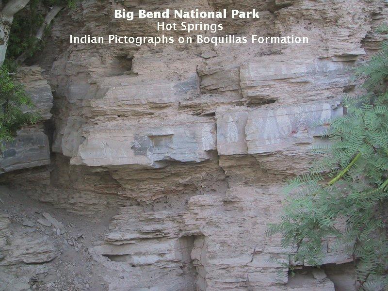
The Langford Hot Springs on the banks of the Rio Grande near the confluence with Tornillo Creek is the largest and most visited. A fellow named J. O. Langford bought the land in the early 1900s and established a health spa. The waters were said to have healing powers. Surrounded by beautiful scenery with the river flowing lazily past, it is certainly a place for the healing of the soul.My brother and I did not hike the entire trail from Boquillas to Hot Springs. There just wasn't time enough left in the day. So we drove to the Hot Springs Historic District and hiked the rest of the way to springs. Along the way you pass an exhibit of prehistoric Native American pictographs on the walls of cliffs composed of the Cretaceous Boquillas Formation. See the image below.
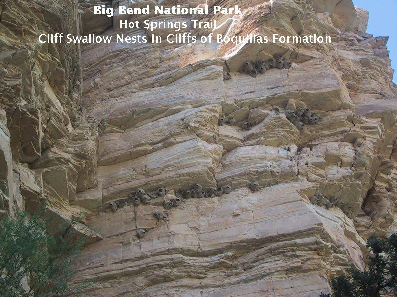
If you look up at the cliffs you will see numerous cliff swallow nests, appearing like fat little roughly made earthen jars somehow stuck to the underside of ledges (below). The introductory image above is a painting by Louis Agassiz Fuertes of a male cliff swallow. (This image is from the museum at the University of Texas, El Paso. To go there, click on the image.) They are certainly handsome birds.
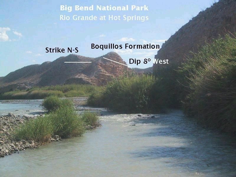
The following image is looking back upstream from a short distance upstream of the hot springs toward outcrops of the Boquillas Formation, across the entrance of Tornillo Creek into the Rio Grande. (Nothing much is left of the bath houses Langford built. Just the foundation. Apparently, the foolish first overseers of the park decided to destroy everything the settlers had built. Only a few things such as the Wilson Ranch headquarters remain. So much of the early settler history in the park is sadly gone.) The outcrops appear to be those of the San Vincente member of the formation (and is so mapped by the USGS), composed of finely bedded limestone, claystone, and shale. Between us and the outcrops is where Tornillo Creek enters the Rio Grand. This image presents an opportunity for a little lesson in what geologists call strike and dip.
Geologists use these concepts to help map the orientation of sedimentary beds. Strike gives the direction of orientation of the beds while dip gives, well, the dip of the beds. In particular, strike is the direction defined by the intersection of a bed with the horizontal. You can determine the strike by, for example, laying a ruler down on the flat surface of a bed such that it is horizontal (a level is handy here). The compass direction of the ruler gives you the strike. Or, imagine one of the flat sides of a peaked roof, which can be considered a geometric plane. The crest of the roof would mark the strike of that plane, whereas the dip would be the angle directly down the plane - the direction you would go if you lost your footing. The greater the angle of the dip, the steeper the bed. In the image you see a horizontal line marking the strike of one of the beds. (The beds all obviously have the same strike and dip, since they are all parallel to one another.) The other line indicates that the beds are dipping at an angle of about 8° to the horizontal toward the west. Now, the beds were originally laid down horizontally ("principle of original horizontality") in the early Late Cretaceous, so they had to have been tilted by some subterranean force since that time.
In a previous field trip, I related my surprise and delight in coming across Inoceramus clam fossils in the Basin - in portions of the Boquillas Formation that had been intruded by igneous rock. Leaving the springs and hiking up a trail that was taking us to views of Hot Springs Canyon, the giant clams appeared again in the Boquillas rocks beneath our feet. A particularly nice example is shown below, embedded in the rock under the trail itself. Note that some of the original shell material is still present even though something like 100 million years of time has transpired. Most of this fossil is what is called a "cast", where sediment has filled up the empty space left by the decaying animal
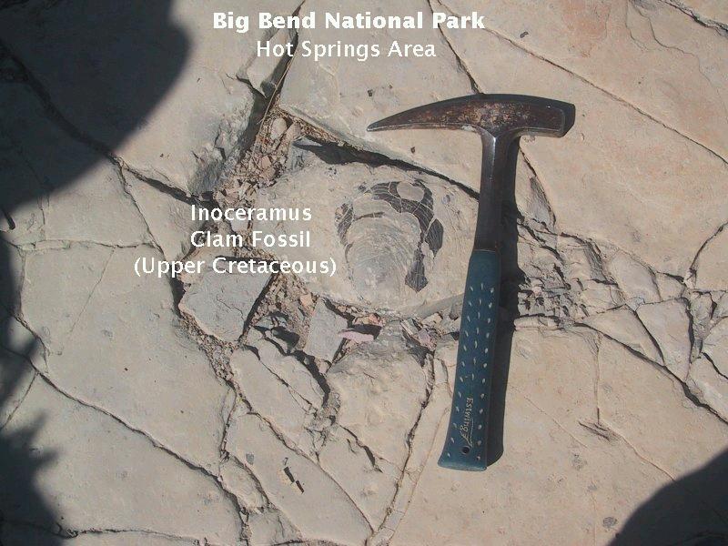
(The fossil is still there. We do not take fossils, rocks, or plants from the park. To do so is illegal and selfish. Leave the park as it is for others to enjoy.)
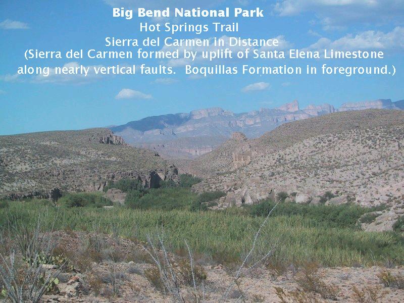
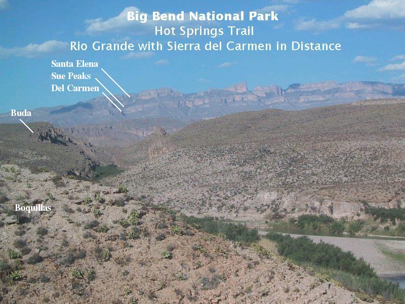
The following two images are of some of the prettiest scenery I've seen anywhere. (Can you imagine the view the Langford's could enjoy in the evening sitting outside their house.) Looking northeast, in the middle distance is Hot Springs Canyon, carved by the Rio Grande into the upper Cretaceous Buda Limestone just on the other side of the dry creek. Farther down the canyon the Rio has eaten into the lower Cretaceous Santa Elena Limestone, which lies stratigraphically just below the Buda, separated from it by only a thin bed of the Del Rio Clay. (The fact they are at the same topographic level is due to the fact the beds of the formations are dipping toward the camera.)
The Boquillas Formation rests stratigraphically on the Buda and here is under foot. In the far distance are the Sierra del Carmen, where the Santa Elena Limestone (at the top of the Sierra) has been uplifted along nearly vertical faults, forming magnificent cliffs. The tower-like feature on the Sierra del Carmen is Pico Cerda (Bristle Peak in Spanish). The offset of the Santa Elena between the riverside cliffs and the Sierra del Carmen testifies to the faulting that has occurred: The Sierra del Carmen have moved upward relative to the closer Santa Elena rocks. Below the Santa Elena in the distance are the slope-forming Sue Peaks Formation, the cliff-forming Del Carmen Limestone, and probably the Mexican-side equivalents to the Telephone Canyon and Glen Rose Formations. Both views below are toward the entrance to Boquillas Canyon. Were we not rushing around to get in as much geological observation as possible, we could have waited a few hours until the setting sun turned the distant limestone cliffs a gorgeous pinkish hue. (We later got our chance to view the cliffs in the setting Sun before starting our Dodson Trail hike.)
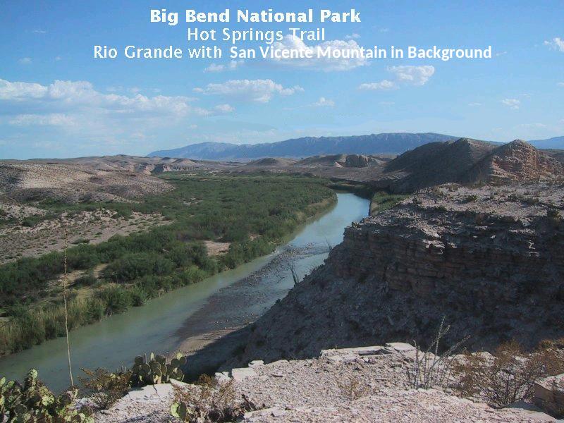
It's a pretty easy stroll to get above Hot Springs Canyon from the springs. The image below is looking in a southwesterly direction. You see San Vicente Mountain looming in the far distance, where the Santa Elena Limestone has been lifted up by the formation of an anticline. An anticline is an upfolded region of crust caused, in this case, by compressive tectonic forces during the Laramide orogeny, a mountain-building event that affected western North America during the later part of the Cretaceous Period through the early part of Tertiary Period. A later mountain building episode associated with crustal extension rather than compression occurred in the Tertiary Period as the western North American Basin and Range Province was formed. This crustal extension is continuing today and is responsible for some of the recent volcanism in the western states as well as a lot of the earthquake activity not associated with the tectonics of the San Andreas fault complex. Little or no activity from this crustal extension has been noted in Big Bend in the last two million years.
The cliffs of the Sierra del Carmen are the result of a major Basin-and-Range fault on the east side of the park. Off to the west and out of sight are the Santa Elena Limestone cliffs of Mesa de Anguila (Sierra Ponce on the Mexican side). The Basin-and-Range Terlingua Fault, with a total of 3000 feet of vertical displacement has produced these cliffs. Most of Big Bend National Park is actually a down-faulted block of the earth's crust called a graben. The Santa Elena Limestone (as well as other rock units) has been lifted up on both sides, forming Mesa de Anguila on the west and the Sierra del Carmen on the east.
Note: The picture I originally had looking southwest from Hot Springs was mislabeled. The distant feature was not Mesa de Anguila as I originally identified. This was a very careless and stupid mistake. I hope to high heaven there aren't more like it in these features! I have to thank reader James Duke for discovering this screw up. It's embarrassing, but I don't want any misinformation in these virtual field trips.
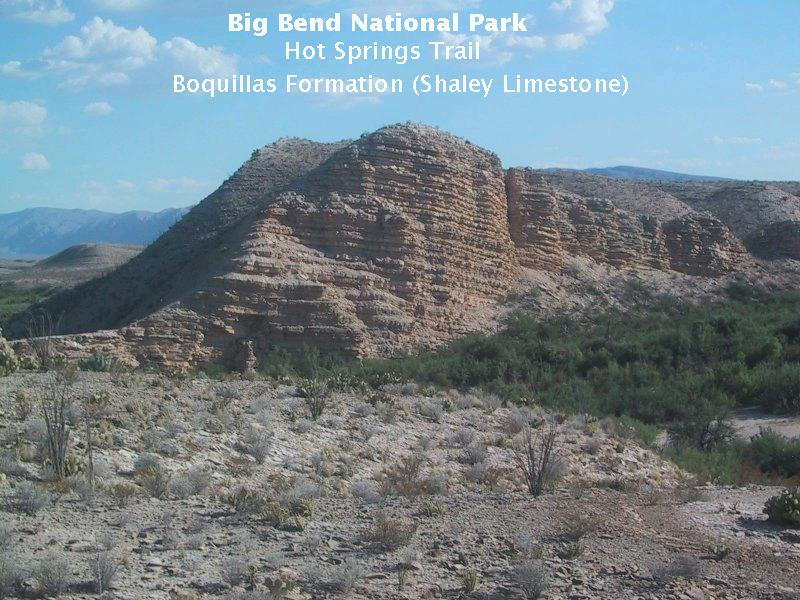
Finally, as you return to the Hot Springs Historic District, you get this nice view of the shaley limestones comprising the Boquillas Formation. The 8° dip to the west is quite evident.
FORWARD to Tuff Canyon
BACKWARD to Boquillas Canyon
ALL THE WAY BACK to the Contents