My brother, Randy, maintains that Lost Mine Trail gives you the most "bang for the buck" in terms of scenery versus effort expended, and, after taking the hike myself, I can't argue with him. The trail begins in Green Gulch in the high Chisos Mountains at a well-marked trailhead and is relatively effortless until you get toward the end, where you do have to expend a bit of effort in elevation gain. However, all along the way you are offered dramatic views of the Chisos Mountains.
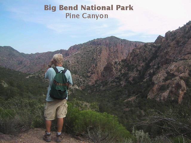
You can look down two canyons as you get toward the end of the trail. The view below, looking east, is of the upper reaches of Pine Canyon, which cuts through the heart of the Pine Canyon Caldera, a small caldera, that erupted around 33 million years ago. (A caldera is formed when lava exits a volcanic mountain, removing the means of the mountain's support. The mountain collapses, resulting in an eruption of pyroclastic volcanism.) The result of this eruption was the deposition of glowing clouds of ash and debris called ignimbrite, forming the Pine Canyon Rhyolite member of the South Rim Formation, formerly known as the Brown Rhyolite. (The nomenclature of the rock units in the Chisos Mountains has undergone a recent change to correspond to the latest research. Some units with the same name and similar properties and age in different parts of the park have been shown not to be the same units.) Rhyolite is a volcanic rock very high in silicon and oxygen and whose deposition tends to be accompanied by violent eruptions due to the high viscosity of the rhyolitic magma, which can trap volcanic gases until the pressure builds up to explosive proportions. However, the sides of upper Pine Canyon consist of the Boot Rock member of the South Rim Formation. This unit includes a variety of volcanic rock types of trachytic to rhyolitic composition, where trachyte has more alkali metals and less quartz than does rhyolite. The Boot Rock member dates to about 32.2 million years old.
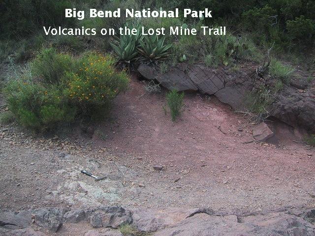
Along the trail you come across the volcanics of the Chisos Formation. The image below is of a layer of Chisos volcanic ash along the side of the trail. The Chisos Formation was deposited in various eruptions and sedimentary episodes beginning around 47 million years ago, prior to the Pine Canyon Caldera eruptions.
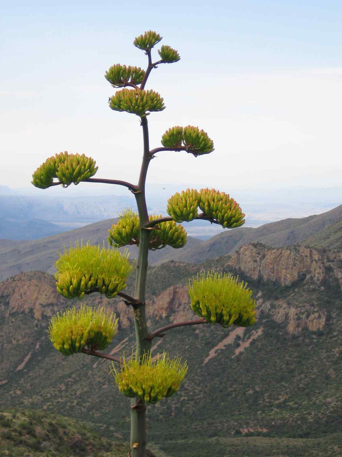
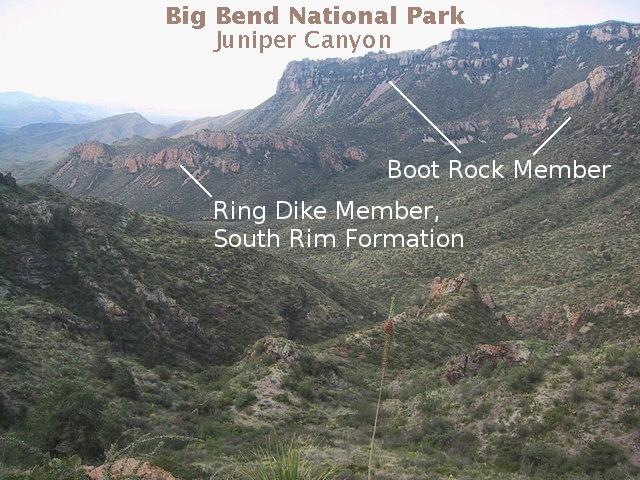
The Agave americana (century plants) were gorgeous along the trail. Below, my brother, Randy, is taking a picture of a particularly nice specimen with beautiful Juniper Canyon in the background. The higher ridges on the right are composed of the Boot Rock member of the South Rim Formation (formerly, the Lost Mine Rhyolite). The lower ridges mark the outcrop of the Ring Dike member of the South Rim Formation, a rhyolitic . igneous intrusion dating to about 32 million years. This rock also forms Hayes Ridge, not visible from the Lost Mine Trail and apparently was part of the dike system that fed magma into the area. (More about dikes shortly.) The gray foreground rock belongs to the Chisos Formation.
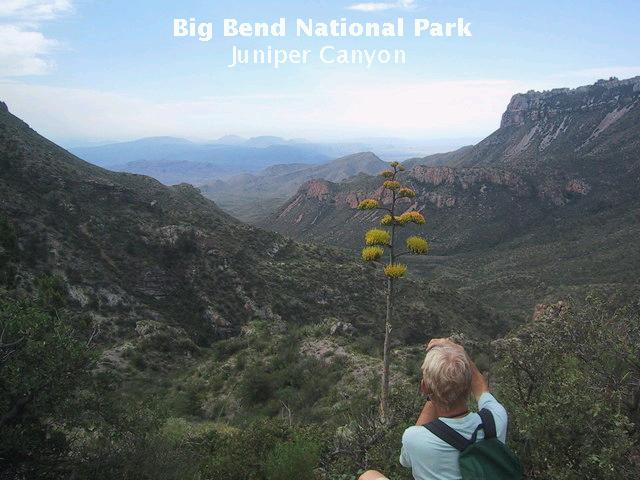
Here is the picture Randy took. The blooming Agave on this hike were spectacular. It could be that the exceptionally rainy spring attributed to their beauty (but I'm no botanist).
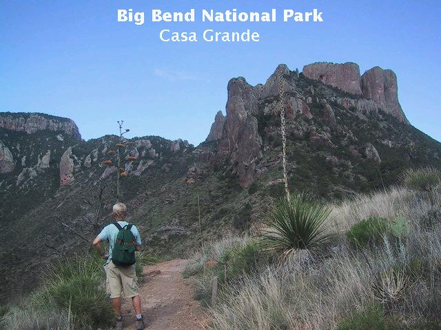
The following picture is a view toward Casa Grande Peak, which is topped by the resistant Boot Rock member, formerly known as the Burro Mesa Rhyolite. (The rhyolite on Burro Mesa has different origin.) My brother, Randy, formerly known as Alan, pauses to take in the view. (Actually, Randy did not have to change his name to suite the new nomenclature. However, in another sense this is true. In England "randy" has a bit of a vulgar meaning, so when we visited him there we would always refer to him by his first name, Alan, in public.)
The Boot Rock also forms the "caprock" on Lost Mine Peak and Toll Mountain, the northern shoulder of which is seen to the left of Casa Grande. Stratigraphically, the Emory Peak Rhyolite, not present in this area, lies on top of the Boot Rock member which, in turn, overlies the Pine Canyon Rhyolite. All these are members of the South Rim Formation, which was erupted between 33 and 32 million years ago. Note the Agave just beyond Randy and the Sotol to his right, both with tall blooms.
Juniper Canyon was particulary gorgeous this trip (June, 2007) due to the wet spring. Canyons such as this widen as mass wasting, processes (for example, rock falls and soil creep) erode away the slopes. The debris from these processes are moved downstream during the infrequent desert downbursts, deepening the canyon.
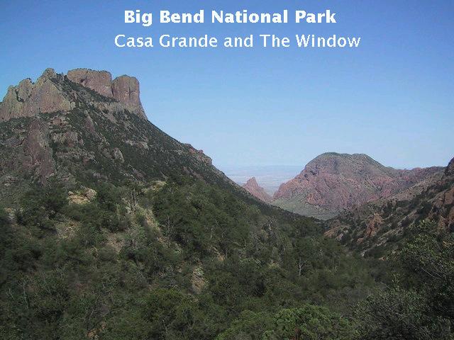
Below is a view back toward The Basin. Casa Grande is on the left. In the distance is The Window, a gap between Amon Carter Peak on the left and Vernon Bailey Peak on the right. The Window is the only outlet for water from The Basin.
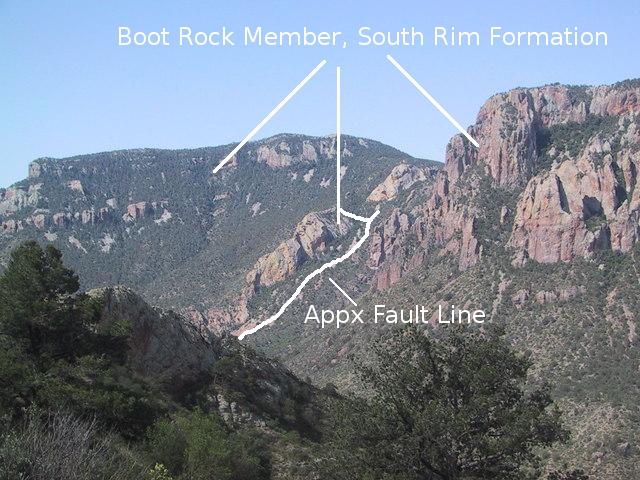
In this view of Juniper Canyon you see what was supposed to be a linear igneous intrusion, but the new USGS map, Scientific Investigations Map 3142, says it is a fragment of the Boot Rock member separated from the surrounding Chisos Formation rocks by faults. In addition to the fault traces shown (approximate locations), a fault line exists on the other side of the fragment. Boot Canyon descends into Juniper Canyon between this feature and the cliffs in the right middle distance.
This is the end of the trail. It terminates at what appears to me to be an east-west trending dike, a sheet-shaped igneous intrusion that cuts across pre-existing geologic structure. However, no dike appears at this location on the USGS map as far as I can tell. Looking at Google Earth, this dike (?) (and another (?) in the vicinity) seem to be continuations of dikes that are mapped at lower elevations cutting into the Chisos Formation. Those dikes are designated as Tir and consist of either rhyolite or similar high-silica, low-iron rock. This apparent lack of correspondence between map and field is a bit confusing.
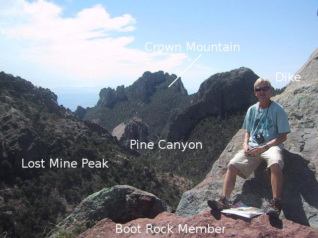
Here you see brother Randolph with his back on the dike (?) and his feet on what was previously known as the Wasp Spring Flow Breccia (now a unit of the Boot Rock member of the South Rim Formation). As indicated in the image, Lost Mine Peak is to the left and Crown Mountain is in the distance. The higher elevations of Crown Mountain consist of the Boot Rock member (formerly the Wasp Spring Flow Breccia overlain by the Lost Mine Rhyolite). The flatiron-looking feature below Crown Mountain appears to be made of Pine Canyon Rhyolite, the original material erupted from the Pine Canyon caldera mentioned above.
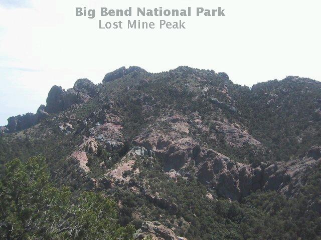
Lost Mine Peak is shown below. Legends of a lost mine on the peak are almost certainly fabrications. Note the grayish rock extending from lower right to upper left across the face of the mountain. This appears to be another igneous dike.
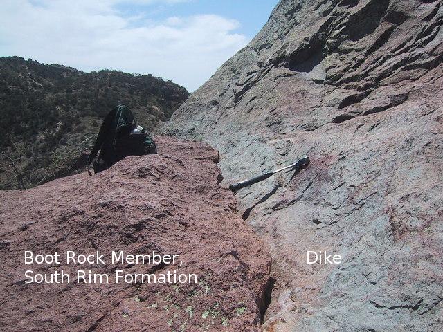
A closeup of the contact between the Boot Rock member and the dike (?) at the end of the Lost Mine trail. The dropoff on the other side of the backpack was originally supposed to be due to a fault but is not mapped as a fault scarp on the new USGS map. I should point out that my rock hammer is only used for scale in photos (or, if camping, to dig "cat holes" or drive tent stakes) It is illegal and immoral to collect rock or fossils, or to do damage in national parks. Occasionally I also use it to help climb up difficult slopes. This was my original rock hammer I left behind and lost at Burro Mesa pouroff. This was sad for me, because it saved me from injury on the slopes of Mt Rainier in Washington state when I slid down a steep snow bank. A rock hammer has numerous uses.
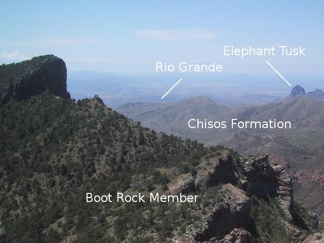
In this view you are looking almost due south. Elephant Tusk and Backbone Ridge (just to the right of Elephant Tusk, on the edge of the image) are in the distance, almost eight miles away. Both are igneous intrusions. Lost Mine Peak is off to the left. The Rio Grande, about 5000 feet in elevation below you and 18 miles distant, is the greenish strip indicated. At this point the Rio has turned northward as it rounds its Big Bend.
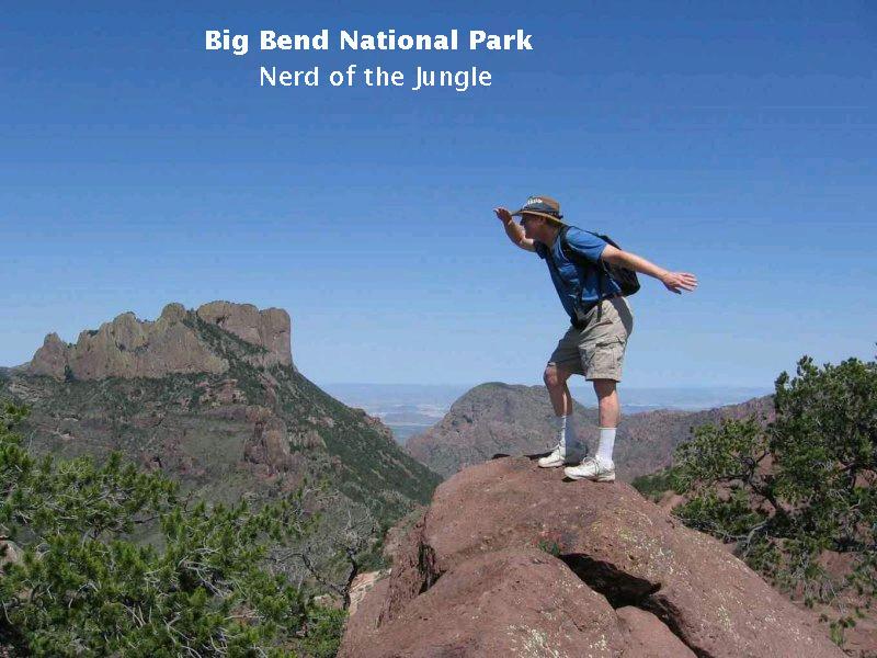
Finally, here is the intrepid explorer viewing the horizon for new lands to conquer. My wife has dubbed this picture "Nerd of the Jungle" and has gleefully sent it to all her relatives.
Nerd, Nerd, Nerd of the jungle,
Mounts the rock with pep.
Nerd, Nerd, Nerd of the jungle,
Look out where you step!
FORWARD to the Chimneys
BACKWARD to Rancherias Canyon
ALL THE WAY BACK to the Contents