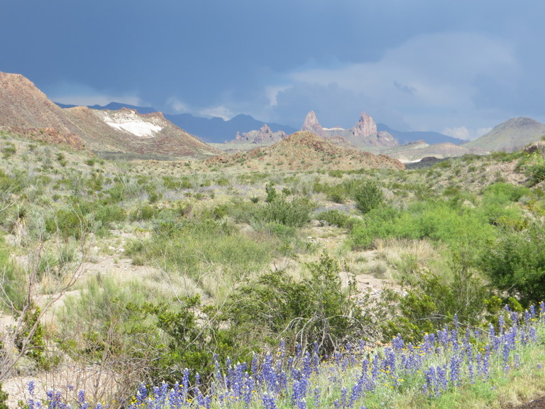
The Maxwell Scenic Highway extends down the west side, between the Chisos Mountains and Burro Mesa through mostly volcanic terrain all the way to Santa Elena Canyon, where you find sedimentary rock in the form of limestone. Named for Ross A. Maxwell, a geologist and the Park's first administrator, it is replete with remarkable views and even more remarkable geologic features. Our first stop is a syncline exposed in the Chisos Formation in the area just west of the high Chisos Mountains. The photo below was taken looking southeast.
(There has been some nomenclature problems here. When I created the image these rocks were called the Chisos Formation, but then I read where "formation" had been changed to "group". A group contains two or more formations. However, the new USGS map of the park – Scientific Investigations Map 3142, 2011 – has reverted back to "formation". If you are by any wild chance interested, you can check out the stratigraphic units nomenclature used by geologists with this link.)
A syncline is a geologic fold where beds of rock have been bent downwards near the center of the fold relative to the sides. A fold in geology can be one of many different types, but the two most common are syncline and anticline, where an anticline is folded up in the middle, rather than down. Anticlines and synclines are divided into two halves, called "limbs", by an imaginary plane called the axial plane (sort of like how the Earth is divided into two hemispheres by the equatorial plane). The axial plane "cuts" the fold at where the curvature is greatest. However, where the plane should be drawn for this fold isn't clear as far as I'm concerned. I gave it a shot, however.
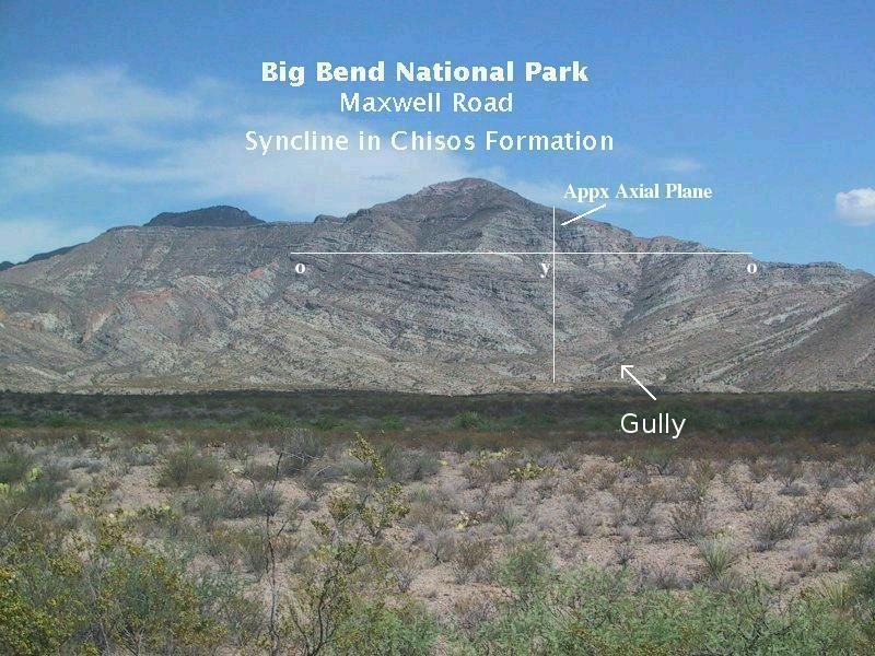
Note the horizontal line and imagine it is the surface of the ground you are walking on, and the cross section of the syncline is not visible. How would you know there was a synclinal fold beneath your feet? Two ways. If you can determine the dips of the beds, note they dip toward the center, and find the same beds on both sides where the dip changes, you have identified the fold. If you can't determine the dips for the lack of good bedding planes, but you can identify the beds by age, you can still determine the fold is there. Noting the same older beds ("o") are on either side of the youngest beds ("y"), you have identified the presence of the syncline. In this case, however, a fault, discussed below, might complicate things. It's almost never easy for the poor geologist.
The new USGS map shows an anticline off to the left of the syncline, but it was not clearly visible from the road. Note the gully running up the hill on the right side. According to the USGS map, it marks a fault that cuts through the syncline. This fault is a zone where fractured rock makes the job of erosive forces easier, hence the formation of the gully. One reference says the rock has been faulted down on the right (south) side of the fault, but the USGS map does not indicate which side is up and which is down, and from the road it is not clear how the movement along the fault occurred. The rocks that have been folded in this syncline are designated the undifferentiated "younger part" of the Chisos Formation on the USGS map, meaning they have not been formally divided up into smaller stratigraphic units. It is clear, however, that much of what you see here consists of lithified (turned into rock) volcanic ash called tuff. The thin, darker beds are probably lava flows.
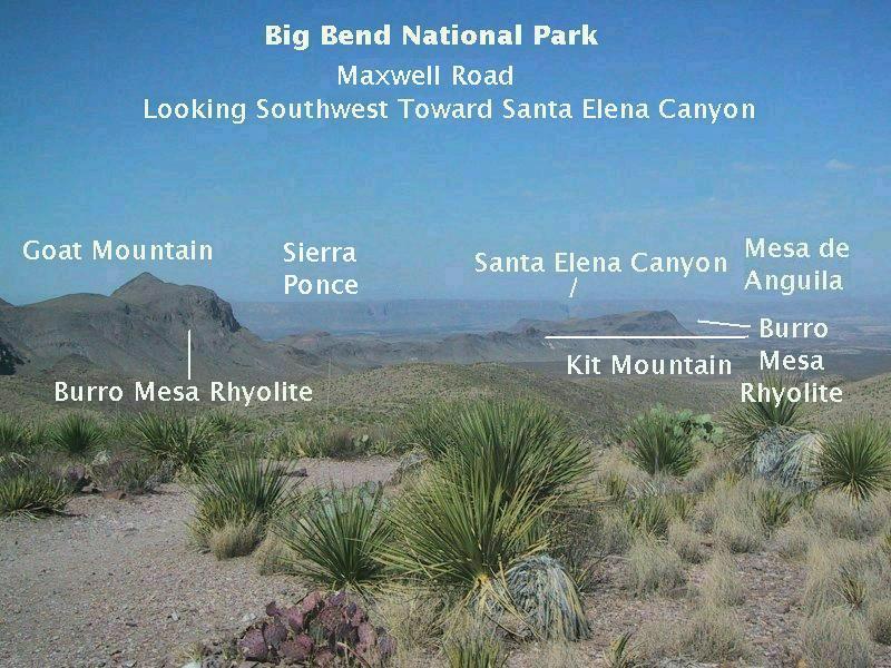
From Sotol Vista, a turnout and viewpoint about seven miles south of the turnoff onto Maxwell Scenic Highway, you get the expansive view seen below. Goat Mountain is on the left and Kit Mountain center right. Goat Mountain is topped with the volcanic rhyolite member of the Burro Mesa Formation, whereas Kit Mountain sports this rock on its west and east ends as shown in the photo. In between the rhyolite on Kit Mountain is the volcanic Wasp Spring member of the Burro Mesa Formation lying on top of another volcanic rock called trachyte. Rhyolite is a volcanic rock high in silica that is the chemical equivalent of granite. The difference is the magma that becomes granite never reaches the surface and so cools and solidifies underground. Were it to reach the surface, it would be rhyolite. The term "trachyte" covers a number of quartz-poor volcanic rock types that are high in alkali metals such as sodium and potassium. If it solidifies underground it is called syenite, a sort of low-quartz granite seen in the park at, for example, Grapevine Hills. Several radiometric dates place the age of this rhyolite at 29 million years. A sample of trachyte dated at Goat Mountain gave an age of 30.3 million years.
The Wasp Spring member records a violent eruption or eruptions. Its texture indicates flows of ash and broken-up rock as well as volcanic blocks and "bombs", which are formed when lava is thrown into the air as liquid blobs and solidifies while in flight. Ages for this member come in at a little over 29 million years. You will see these units close up on Goat Mountain farther down the road. In the distance you can see the 1400-foot scarp marking the eastern edge of Mesa de Anguila and, just visible in the scarp over Kit Mountain, is the notch that marks the position of Santa Elena Canyon. From this distance the canyon seems puny.
One of the most interesting geological features along the Maxwell highway is Goat Mountain. When I first wrote about Goat Mountain in this field trip, there was some uncertainty about the setting in which the volcanic vent, marked now by a volcanic plug on the west side of the mountain exposed by erosion, was active. Geologists Maxwell (The Big Bend of the Rio Grande) and Darwin Spearing (Roadside Geology of Texas), write that the eruption occurred in a preexisting canyon, whereas an interpretive exhibit at the Goat Mountain turnout and William MacLeod (Big Bend Vistas) claim the "canyon" is actually the result of the eruption itself. Closer examination of the mountain appears to support the latter interpretation, but nothing is said about this in the latest USGS work. For a long time I just left the photo I had marked up with an interpretation of the mountain's geology as it was, with the canyon's former surface indicated by a white line. (I've heard that slothfulness is one of the seven deadly sins, but I haven't bothered to check if that's true.)
Well, I've finally made the change and got rid of the (likely) offending interpretative photo. Plus, new information has been incorporated into the photos shown below. Also, the previous interpretative photo was taken in bad light. Recently I have been able to get better photos and use the USGS map for a more up-to-date take on the geology. Unfortunately, the photo of the whole mountain didn't turn out, but I did get four decent photos, of the north side, a close-up of the north side, the south side, and the vent.
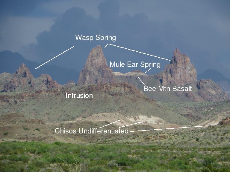
The north side of Goat Mountain is a layer cake of volcanic rocks. The two photos below are of that layer cake, with the second photo being a close-up. The lowest layer is the undifferentiated Chisos Formation rocks mentioned above. This designation includes rocks that span the entire stretch of time of the younger Chisos Formation rocks, with ages between 45 and 33 million years as indicated by a number of radiometric dates. In other words these rocks clearly belong to the Chisos Formation but don't belong to the recognized members of that formation. That means they need further study to see if they can be differentiated into distinct members (assuming that's possible). Hence the younger Chisos Formation rocks that lie above and below the recognized members and have not been categorized are designated with the catch-all "undifferentiated" term and labeled Tcy on the USGS map.
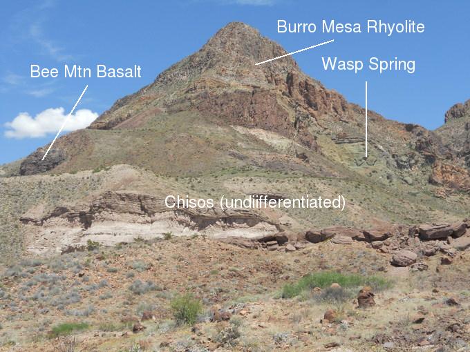
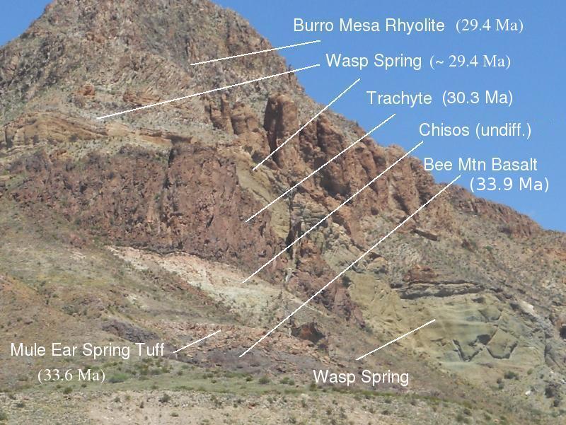
The next layer is the dark rock of the Bee Mountain Basalt member of the Chisos Formation, which was erupted over a period stretching from 34 to 33 million years ago. Basalt is an iron-rich volcanic rock with relatively less silica than rhyolite. The basalt here has not been dated to my knowledge, but the Mule Ear Spring Tuff just above it was dated to 33.6 million years. Outcrops of the basalt far to the east and west of Goat Mountain have been dated to a time that falls within the error bars of uncertainty for the samples taken. That is, statistically both outcrops date to the same time, a date close to 33.9 million years ago. Above the tuff is some more of the undifferentiated rock of the Chisos Formation... and that does it for the Eocene to early Oligocene Chisos Formation.
The rocks farther upstairs begin with a 30.3 million-year-old trachyte, which had been previously mapped as the 33 million-year-old Tule Mountain Trachyte, but newer work (Daniel P. Miggins et. al. in USGS Circular 1327) has shown that it is younger. Above that are the Wasp Spring and Burro Mesa Rhyolite members of the Oligocene Burro Mesa Formation that have already been described. Only the Burro Mesa Rhyolite and the Wasp Spring can be seen in the photo below of the south side of Goat Mountain, since the lower units are covered by debris. However, farther to the right of the photo they show up again.
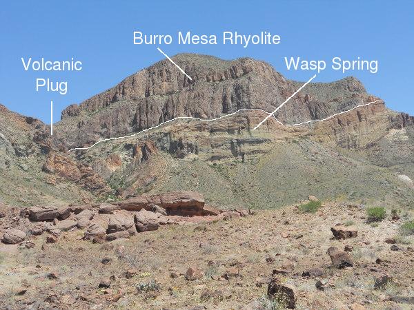
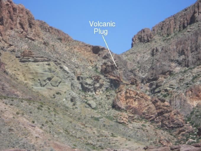
Cutting through the Chisos rocks is an intrusion of rhyolite, marking the site of a volcanic vent. The intrusion represents some of the last of the magma that didn't make it out, and now it's a volcanic plug. The eruption resulted in the Wasp Springs Tuff and, on top of that, the Burro Mesa Rhyolite. Both units were apparently erupted from a number of volcanic vents on the west side of the Chisos Mountains. The ages of these two units are so close, it seems likely they were erupted rather closely in time, one after the other.
The next picture is of one of the most famous landmarks in the park. From a distance you would swear there was this gigantic animal crouching down behind a ridge with just his ears and the top of his head showing. The ears look very mule-like, hence the name "Mule Ear Peaks". They are actually the eroded remnants of a pair of dikes.
The rock of these dikes is mapped as Wasp Spring by the USGS, implying that these dikes used to be volcanic fissures that violently erupted at least some of the Wasp Spring member of the Burro Mesa Formation found in this area of the park. The thickest exposures of the Wasp Spring are found to the north of Mule Ear Peaks, at the Burro Mesa pouroff and along Blue Creek. The new rock feature here is the intrusive rock marked in the photo, also assigned to the Burro Mesa Formation. It is not dated at this location, but two samples near the Burro Mesa pouroff give ages of 29 million years. Also in the picture is trachyte, as found at Goat Mountain.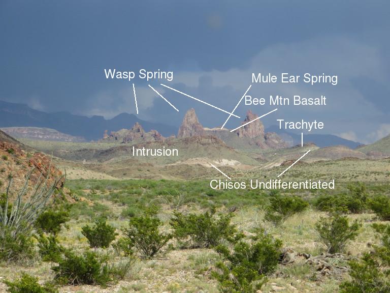
Taking a closer look at the "Ears", you can make out the Mule Ear Spring Tuff and the Bee Mountain Basalt. When I first looked at this view, it appeared that the small peaks to the left of the Ears were part of a dike that extended from the left Ear toward the Chisos. However, I didn't recall any such feature on a previous hike to Mule Ear Peaks. A perusal of the Cerro Castellan quadrangle proved that this "dike" feature was merely a problem of perspective in the dry desert air. The small peaks are actually closer to the camera than the Mule Ear Peaks.
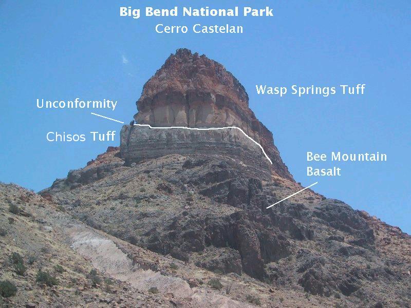
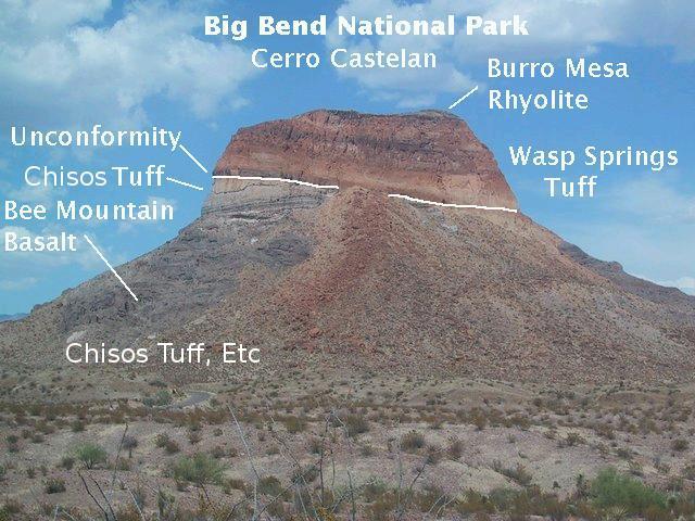
As you get closer to Mesa de Anguila (called Sierra Ponce on the Mexican side), you drive by Cerro Castellan (below, looking southeast), an erosional remnant that, due to its rather isolated position, stands out prominently. Thanks to the USGS map, and a report in USGS Circular 1327, 2008, by D. P. Miggins et. al. I can correct, I hope, the geology of this feature from what I originally understood. (It turns out the interpretive diagrams of Cerro Castellan in Roadside Geology of Texas by Darwin Spearing and Big Bend Vistas by William MacLeod are apparently in error. A different interpretation based on Circular 1327 is more detailed and up to date.)
The Burro Mesa Rhyolite and Wasp Spring members of the Burro Mesa Formation protect the rocks below from erosion and form a "caprock". The unconformity, is the boundary between the Chisos Formation below and the Burro Mesa Formation above. The Wasp Spring is a welded tuff called an ignimbrite that resulted from a violent eruption. The white rock below is tuff belonging to the Chisos Formation and is not welded (that is, fused into very hard rock), indicating it may have been an ash fall rather than a violent hot ash flow. Below this unit is the Bee Mountain Basalt member of the Chisos Formation and beds of ash and tuff of undifferentiated Chisos Formation rocks.
The rock units here have been dated. The Bee Mountain Basalt comes in at 33.4 million years old and the Wasp Spring at 29.3 million years. However, the age for the Burro Mesa Rhyolite, 29.5 million years, is incompatible with the Wasp Spring - even when you take into account the "error bars" in the dates - so one or the other must be wrong. I suspect it is the age of the Burro Mesa Rhyolite sample dated at this location, since the dates at other locations are younger. And, to reiterate, these two units were probably erupted so close in time that it is difficult for radiometric dating to distinguish them.
Below is a view of Cerro Castellan from the side, looking east. Under the Burro Mesa Formation, as mentioned above, there is a time break, called an unconformity, during which erosion took place. It appears what you are looking at here is what is left of one side of a valley into which the Burro Mesa Formation was deposited. The unconformity may mark what used to be part of the valley floor. However, there may be another unconformity here within the Chisos Formation. Finally, note the talus (debris) from rock falls of the Burro Mesa Formation. This is a reminder that erosion is still at work, and, geologically speaking, Cerro Castellan is not long for this world.
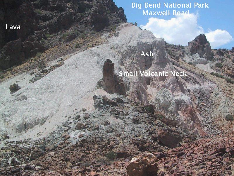
Continuing along Maxwell Scenic Highway toward the Rio Grande, you cross a landscape carved into the volcanism of the past by erosive forces. You see lava, tuff, ash, and, in the following image, a remarkably tiny volcanic plug (or, neck), which marks a vent through which some of the 29-million-year-old Burro Mesa Rhyolite was extruded. The flow of lava through a tube-like opening in the earth created a texture where the lava was in contact with the walls of the tube, making the tube look for all the world like a petrified tree stump. It even has a "knot". No wonder this is what many thought it was. However, the "stump" is composed of solidified lava, and the knot is probably where some piece of rock caught up in the flow later weathered away, creating a hole. Other such vents have been located around Cerro Castellan.
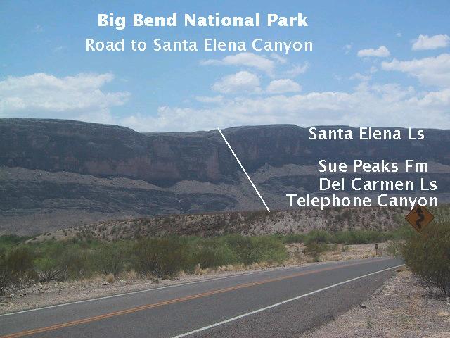
As you approach the Rio Grande, Mesa de Anguila (actually, Sierra Ponce, as it is known in Mexico) looms up before you, 1400 feet above the river. This side of the mesa is a fault scarp due to the Terlingua fault - the rock across the Rio has been uplifted 3000 feet relative to that on this side, forming the western boundary of the down-faulted crustal block upon which much of Big Bend National Park sits. The east side of the block is bounded by the fault that created the Sierra del Carmen escarpment. As mentioned in other episodes of this virtual field trip, the Chisos Mountains are high, not because they have been lifted up, but because the land around them has been eroded down. The Chisos owe their existence to the very resistant rock that caps the mountains.
In the image below you see that another fault has cut the mesa escarpment, down on the left and up on the right. Also, the rock layers are labeled. On top is the massive Santa Elena Limestone, over 700 feet thick. Below it is the Sue Peaks Formation, a blend of shale, marl, and limestone. Much less resistant than either the Santa Elena above it or the Del Carmen Limestone below it, it tends to form slopes rather than cliffs. The 150-foot thick Del Carmen is relatively resistant like the Santa Elena and is a ledge-forming unit. Beneath that is the relatively easily eroded Telephone Canyon Formation, consisting of 25 feet of limestone and marl.
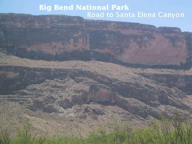
The Rio Grande (out of sight at the base of the escarpment) is continually undercutting the cliffs such that from time to time they give way. The result is a landslide or rockfall. The collapse you see below appears to be a bit of both. Although it appears to have been a somewhat chaotic collapse, which would make it a rockfall, there are also preserved bedding planes and an upright block of Del Carmen Limestone, which imply a more coherent collapse, consistent with a landslide. And, possibly, more than one event led to what is seen here.
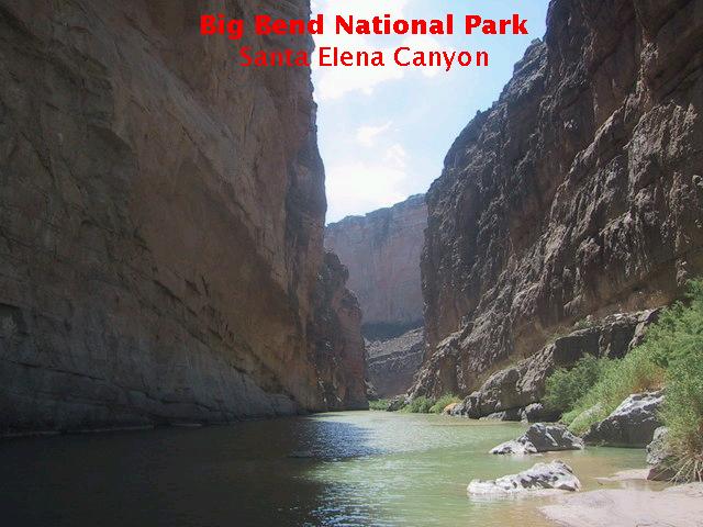
The canyon which was almost invisible from Sotol Vista (and is invisible on days of poor air quality), and even if visible appears to be a tiny chink in Mesa de Anguila (which itself looks like a something you could mount with a couple of steps), now appears as a huge narrow gash in the mesa, with sheer walls that tower well over 1000 feet above you. The canyon has frustrated many a traveler trying to move up the river. There is no trail that continues all the way through the canyon. The cliffs of Mesa de Anguila (and Sierra Ponce) are insurmountable. The currents in the canyon can be swift and difficult to fight.
You can, however, cross the (usually) dry bed of Terlingua Creek, up and over a shoulder of rock, and down to a riverside trail that leads up the canyon, gradually playing out. The canyon deserves its own entry in this compendium of field trips, so this will wrap it up for the Maxwell Scenic Highway.
FORWARD to The Burro Mesa Pouroff
BACKWARD to The Road to Terlingua
ALL THE WAY BACK to the Contents