A Rather Miner Story: Mariscal Mine
While I was poking around in the desert in June, 2016, I had time to do something I have been wanting to do for a very long time but never got around to it: explore the Mariscal Mine. There is quite a story here that extends beyond the mine itself to the surrounding region and the "Great War" (World War I). The prosecution of that war required lots of the element mercury, and the main ore for mercury is the mineral cinnabar, mercury sulfide (chemical symbol HgS), which was found in abundance in the Big Bend area. Before the Mariscal Mine went into operation, there were ongoing operations in what is known as the Terlingua mining district. The Mariscal Mine was a rather minor operation compared to the Chisos Mining Company at Terlingua and the Big Bend Cinnabar Mining Company at Study Butte. A detailed history of the Mariscal Mine can be found online at the Library of Congress.
Cinnabar is a rather colorful mineral that can take various shades of red, from scarlet to brick red to dull red. It is deposited from hot fluids emanating from a magma body or from hot spring vapors. Since it condenses at low pressures and relatively low temperatures, it is emplaced near the surface of the earth and rather far from main magma bodies when deposited by volcanic activity. In the case of the cinnabar ore in the Big Bend area, volcanic deposition seems to have been responsible. For example, there are the remains of an igneous intrusion of rhyolitic rocks running along the east side of Mariscal Mountain, which is topped here by the upper Cretaceous Boquillas Formation. Rhyolite is a volcanic rock with a relatively large silicon to iron ratio – the volcanic equivalent of granite. Farther south the mountain consists largely of the lower Cretaceous Santa Elena Limestone.
Mining in the Terlingua district began about 1896 and continued to 1970. More than thirty mines were active at one time. Texas was second only to California in the production of mercury and even exceeded California in 1921. A local rancher, Martin Solis, discovered cinnabar at the northern-most point of the Mariscal Mountain anticline in 1900. (An anticline is an upfolded section of rock.) Subsequently, there were four "eras" of mining operation there: the Lindsey era from 1903 to 1905, the Ellis era from 1916 to 1919, the Mariscal era from 1919 to 1923, and the Vivianna era from 1942 to 1943. During the Lindsey era, ore was mined and transported by wagon to Terlingua where it was processed by the larger mining companies. Processing of the ore on-site began with the Ellis era.
Unfortunately, since I had no plans to visit the mine before my trip to Big Bend, I failed to research it. As a result I walked right past the Ellis era buildings, thinking they were some sort of quarters. Ellis began extracting the mercury from the ore using a retort process. This was the most productive period of the mine as it provided mercury for the war effort but ended after the war when mercury prices fell.
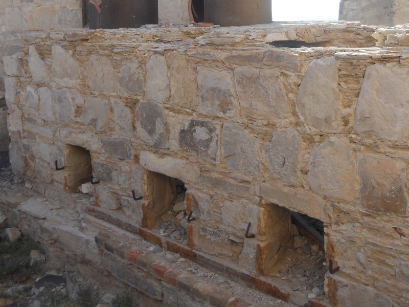
Update: I was able to get back to the mine area in October, 2019, and do better justice to the Ellis era. The side of the first building you encounter on the trail looks like one of the spartan quarters out on the desert floor, but if you turn around to look after going by, you can see what appear to be the Ellis era furnaces. The following picture is of that structure from a slightly elevated position to get a better view. The round openings to the left of the building are apparently where the furnaces were. Talley Mountain is in the distance.
The condensers of the Ellis era, where the mercury vapor was cooled and liquid mercury collected, appear to be lower and beyond the structure above. Much of the Ellis structure must be underneath the later mine tailings with just a part of the condenser structure showing. There must have been pipes carrying the vapor down from the furnaces and liquid mercury likely was collected in gutters under the square doors. This picure was taken standing on the furnace structure looking in an easterly direction.
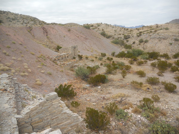
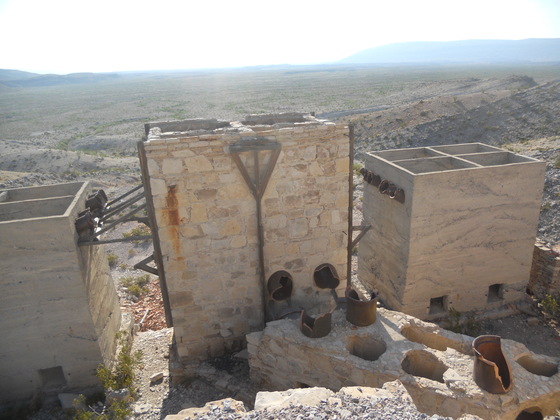
In June 2016, "dissing" the Ellis era, my first picture, below, is looking up at the buildings of the Mariscal era, which are much more impressive and eye-catching than those of Ellis.
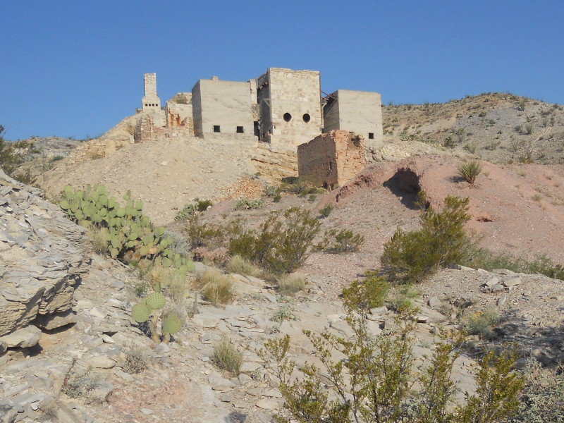
The ruined building with red brick is the Scott furnace. The brick is red due to contamination by mercury. William D Burcham, who operated the mine in the Marsical Mining Company era, built it in 1919 to heat the ore and release fumes containing the mercury vapor. It is thought that he may have dismantled the furnace during the Vivianna era to extract mercury from the contaminated bricks. The furnace fed fumes to the center building in the background through ceramic pipes, now missing, into the round holes. Fumes were subsequently fed into the other two buildings. These buildings were known as condensers, and their purpose was to cool the mercury vapor so it would condense into liquid mercury. The chimney in the distance was originally connected to the condenser system by pipes and was the final destination for the fumes. To the left of the left-most condenser are the remains of the soot furnace used to further treat soot and dust from the condensers to extract any mercury that might be left. Finally in the picture, the Mariscal era mine tailings are seen below the Scott furnace.
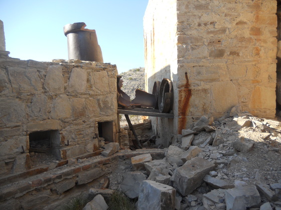
In the next photo you can see what's left of the condenser system. The condensers were connected by ceramic pipes to funnel and cool the fumes. However, the fumes were still too hot for much mercury vapor to condense in the three buildings comprising the main condensers. They were fed from the main condensers into the diagonally oriented structure, the middle condenser, where most of the mercury was collected. Part of the soot furnace can be seen at the far right.
The middle condenser fed fumes into yet another condenser as shown below. The square openings are apparently where iron doors used to be. Mercury would flow out of small holes in these doors and into the gutters on the side of the condenser for collection. Later Burcham installed a couple of large redwood tanks for the fumes to pass through after going through the condensers and before going to the chimney, apparently in an attempt to improve the efficiency of the operation. No trace of them remains as far as I know. They were located just beyond and on the left side of the last condenser structure. In spite of all the improvements Burcham made – perhaps at the expense of actual production – the Mariscal enterprise eventually failed and was shut down in 1923 as the price of mercury remained low after the war.
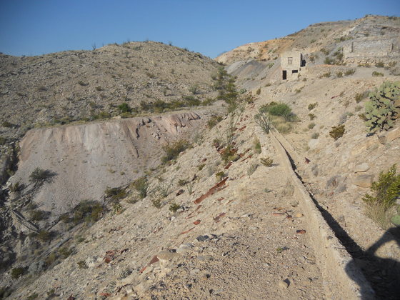
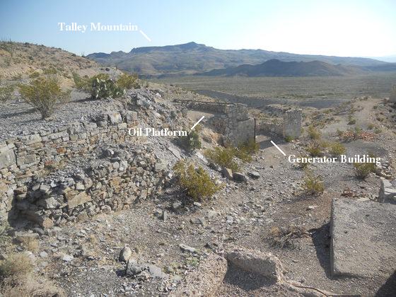
The next view, taken at the chimney location, is of the condensing trough used in the Vivianna Mining Company era to move mercury downslope from where it was produced. The Vivianna era was also the operation of William Burcham. Above and to the right of the trough is the rail bed of the rail system that moved ore downslope in both the Ellis and Marsical eras, from an upper ore bin to a lower bin located back beyond the chimney. The building near the top of the trough was the office of the Vivianna era. Off to the right of the office and out of sight was the generator building used in both the Mariscal and Vivianna eras. On the far side and above the generator building was the oil tank platform, presumably to supply fuel to the generators. Vivianna era mine tailings are in a pile to the left and the grayish debris in the far distance is likely from excavating the mine openings.
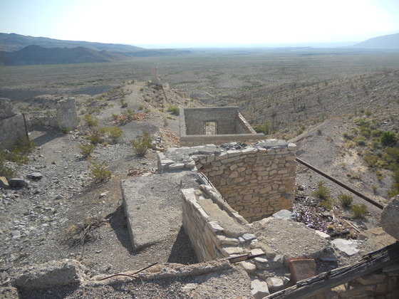
The next picture was taken standing on the ore platform looking northeast. The upper ore bin is in the foreground with the Vivianna office just beyond that. Also note the condensing trough and the rail bed extending down toward the chimney. Just to the right of the office was the platform for the Gould rotary furnace and condensers of the Vivianna era. Burcham installed this furnace to replace the Scott furnace, which had had so many problems in the Mariscal era, as it was a much improved technology. Vivianna tailings are to the far right. In the far distance to the left is the extreme southeast part of Talley Mountain with San Vicente Mountain at the extreme right. The dark hills are probably composed of an Eocene igneous intrusion of basaltic composition.
Looking a bit to the left of the previous photo, you can see the oil tank platform with the generator building below it. In the distance is Talley Mountain. Burcham revived mining here in 1942, naming the enterprise the Vivianna Mining Company, due to the increased demand for mercury to prosecute World War II. However, this operation also failed and was closed in 1944. Equipment that could be salvaged was sold off, including the Gould furnace.
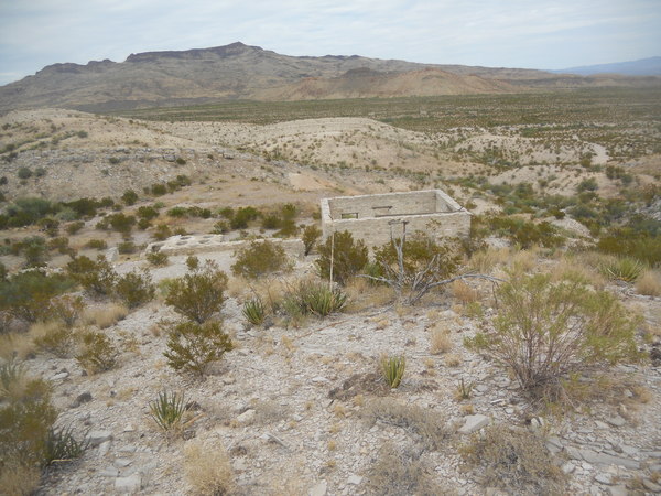
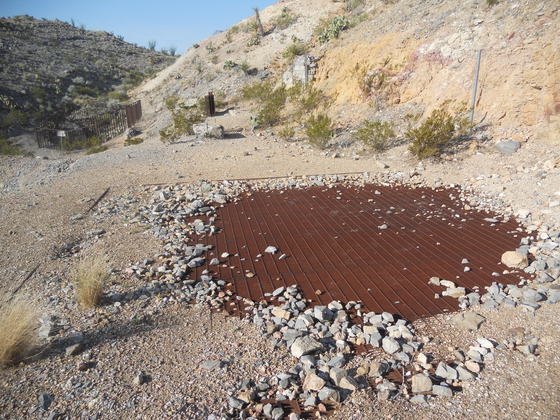
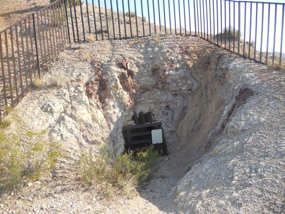
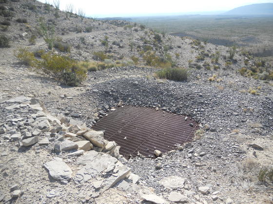
This next picture is the covered main mine shaft with a secondary opening in the background, the purpose of which I couldn't find out. There was a hoist here to lower miners in cages (most likely) and raise ore in large, trapezoidal-shaped buckets.
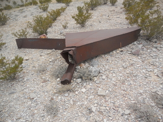
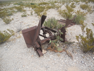
In my October, 2019 visit, I found what I think are remnants of these buckets. Check out the two pictures below.
The shaft was 60 feet deep in the Ellis era. Burcham extended it to 250 feet in 1917, hoping to reach the Buda Limestone. The rock that contained the ore that was mined was the Boquillas Formation. The Buda Limestone, stratigraphically just below the Boquillas and also of upper Cretaceous age, often contains abundant cinnabar, and Burcham was hoping to find higher-grade ore by reaching it. In the Vivianna era Burcham extended the shaft into the Buda to a depth of 438 feet, but no "drifts" (horizontal mine openings used to extract ore) were ever excavated at that level; the lowest drifts were at 250 feet.
And here's another opening. Possibly openings other than the main shaft in this area were either exploratory in nature or made to mine seams of cinnabar.
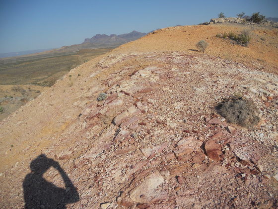
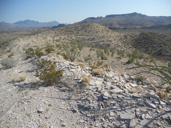
Above all the mine workings there is a small summit on which low-grade cinnabar is present. In the distance to the west is the Punta de la Sierra. The shadow is only there to provide scale. ;-)
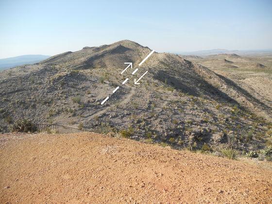
Next, still on the summit, you are looking SSE down the trend of the Mariscal Mountain anticline. You can see the Boquillas rocks dipping in opposite directions as a result of the anticlinal folding, but also the surface trace of a thrust fault. Note that the rocks on the left and right meet at an angle. The rocks on the right have been thrust under those on the left as indicated. This fault was probably formed about the same time as the anticline; that is, during the Laramide mountain building event of the late Cretaceous and early Tertiary Periods. There is another fault, a dip-slip , that splays off the east side of the thrust to the north through the mine. In fact, miners likely encountered both faults while creating mine openings.
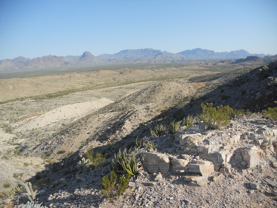
In the next picture you see a view toward the NW with, left to right in the distance, Backbone Ridge, Elephant Tusk, the South Rim of the Chisos, Cow Heaven Mountain, and Hayes Ridge. The steeply dipping Boquillas beds are clearly visible on the west side of the anticline. In between the Boquillas and the low yellowish-tan ridge are recent alluvial sediments (sediments laid down by moving water). The ridge is a bit puzzling to me. According to the recent USGS map, the ridge should be topped by a basaltic igneous intrusion. However, that rock should be dark. The intrusion is easily seen to the west of this ridge, where it appears to lie on the ridge's west side. The light rock is mapped as the upper Cretaceous Aguja Formation lying above the older Pen Formation; however, often there is a ledge-forming sandstone bed at the base of the Aguja, but it doesn't seem to be present here (or, at least, I couldn't see it).
There is an old road that begins at the main shaft and proceeds down toward the River Road. I decided to follow it to see if it did join up with the River Road, in spite of this meaning I might have to do more hiking than I had planned. (After the mine I was going to drive up to the Basin and backpack up into the Chisos.) I was pretty sure this road was the route taken by ore wagons of the Lindsey era on their way to Terlingua. Below is a section of the old road.
Along the road I came to what I took as the north mine shaft, picture below. This was the second ore-producing shaft and extended downward 100 feet.
I began to wonder if the road might end, and I might have to continue cross-country or return the way I came. The next picture indicates my worst fears were realized! Boulders, marking the end of the road!
My fears were misplaced. The boulders are evidently there to prevent vehicles from using the road. The road actually continues beyond the boulders but in much worse shape. I'm not sure why that should be. The road from the boulders back up to the mine looks as if it could have been maintained in the not too distant past, but for what purpose I don't know. There are other old roads around the mine that you can find on Google Earth. This one does go to the River Road but fizzles out several yards before it reaches that road such that it is pretty much invisible were you to look for it while driving the River Road.
When I arrived at the mine, I thought there would be some sort of self-guided tour with informational plaques or whatnot, but the only sign is at the parking lot with minimal information. I realize the mine is halfway down the River Road and occasionally inaccessible even to 4WD, high-clearance vehicles, but most of the year tourists can get there. Also, I've seen a number of what are apparently guided tours by vehicle, although I don't know how often they run or how many people are involved on a yearly basis. Presumably, the tour guides would be able to explain the history and workings of the mine.
But why not have interpretive signs or plaques for those who aren't part of a tour? How much could it cost? I realize the national parks are strapped for funds thanks to all these nitwits in Congress, but I think this would make for a nice park attraction, letting people learn of the history of the mine instead of just looking at the buildings with little or no clue as to when they were built, by whom, and what their functions were. Having worked in mines and with a geology degree, I was able to figure a few things out. I knew they had to roast the ore and condense the mercury vapor. But where were the furnaces necessary to do that? I only later learned that there was a Scott furnace that had been mostly torn down and a rotary furnace installed during World War II, now missing. A lot of the piping is missing, so it is not easy to figure out how the fumes were handled. I'm going to email the park superintendent and make a suggestion.
BACKWARD to East of Talley Mountain
FORWARD to Pine Canyon
ALL THE WAY BACK to the Contents