The title of this section is a quote from, I believe, a trail guide in either a book or on the Web. I can't remember where I read it, but I do remember the author saying something to the effect you may as well throw up your hands and admit defeat a priori. You aren't going to make heads or tails of the rocks you see on this trail, so just give up before you even start hiking. Fortunately, my brother, Randy, and I didn't throw in the towel just because someone said we should. What you can find - if you paid attention in your freshman geology class and look carefully - are numerous dramatic geological features.
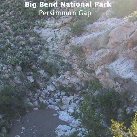
The trail runs up a drainage through outcrops of Mesozoic rocks, some of which are resistant to weathering and form pouroffs (dry waterfalls), such as the one you see below, which appears to be an outcrop of the Aguja Formation. This one was too high and steep to assault head on, so we made our way around it. The picture was taken while ascending the south side of the arroyo, looking down at the sand at the bottom of the pouroff.
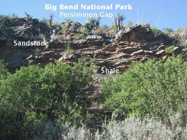
Farther along the trail you come across Paleozoic rocks, such as the ones pictured below. This outcrop features sandstone lying on top of shale and is probably the Tesnus Formation of Late Mississippian to Early Pennsylvanian age. (Update: This identification made before the 2011 appearance of Scientific Investigations Map 3142 by the U. S. Geological Survey, which appears to support it.) The Tesnus consists of sediments deposited by turbidity currents, which are mixtures of water and sediment (a sort of slurry), that flow downhill off continental shelves under the influence of gravity. Hence, this area, that is now continental desert, was once off the continental shelf
Eventually, we came to an outcrop that really did tempt me to throw away the geology books. At first it was hard to figure out what we were looking at. After some observation and thought, it became clear we were looking at a faulted fold exposed by erosion. The beds above the head of the rock hammer were originally continuous with those running along the bottom of the image. The missing sections of beds, removed by erosion, extended out from the outcrop just above the rock hammer and arched back into the outcrop below the hammer. The axis (center) of the fold is marked by the dashed line. The outcrop surface cuts across the fold diagonally, which is why you see the fold has a "nose" to the right. Visible across the upper right is the trace of a fault.
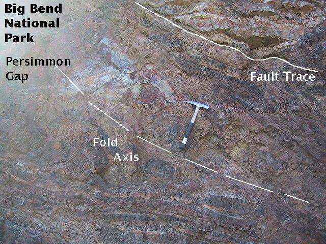
Below you get a better view of the fault. Note how the beds on either side are in very different directions. The outcrop here is the Maravillas Chert of upper Ordovician age.
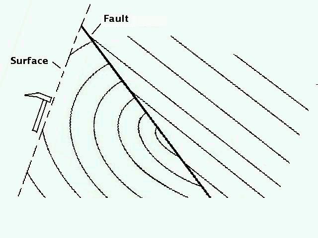
My interpretation of the faulted fold is displayed as a cross-section of the outcrop in the following diagram. In this picture the head of the rock hammer is located right on the axis of the fold, with beds "coming out" of the outcrop above the hammer and "going back into" the outcrop below. Actually, I think the folding is tighter than pictured in this artwork.
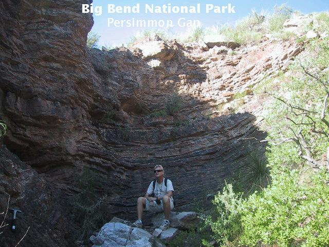
Here, a small pouroff in the Maravillas Chert provides shade from the increasingly warm temperatures. (The hike was undertaken in the morning.) Randy provides the scale.
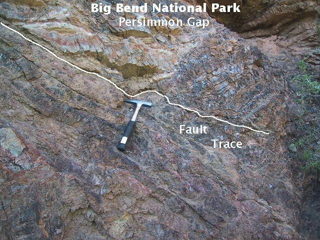
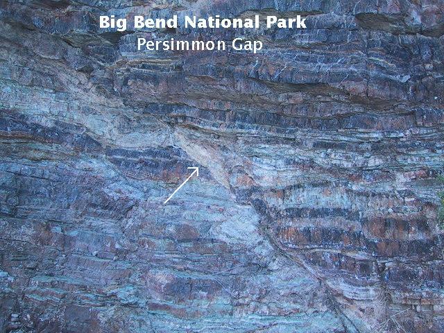
Below is a small fault in the Maravillas Chert with an apparent offset of about one foot. The line marks the trace of the fault. I say "apparent" because there is no guarantee the fault motion was parallel to the ground. All one can say is that the minimum offset was about one foot.
Yet another fault in the Maravillas. This one appears to be a small thrust fault.
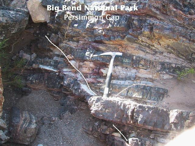
Brother Randolph does the scale thing in front of a prominent fault in the Maravillas Chert, subtended by the arrows. When I examined this fault, I first supposed it was a reverse fault. However, I was not able to correlate beds on either side of the fault plane to show this to be true beyond a doubt. Although thrust faults in the area prove strong compressive forces once occurred in this region (during the late Paleozoic and again during the Late Cretaceous to Early Cenozoic), there could well be compression in one direction and "tension" in another (actually, compressional forces in one horizontal direction that are less than those in perpendicular horizontal and vertical directions - pardon the nit picking, but I am a physicist). So, even in a compressional environment it would be possible to have a normal fault. If the fault pictured were a reverse fault, the rock above the fault plane would have moved to the left relative to below. The opposite occurs for a normal fault. However, this is assuming the motion along the fault was parallel to the outcrop, which is unlikely to be true, as it is quite probable at least some of the motion was perpendicular to the outcrop. Nevertheless, chances are it is indeed a reverse fault.
Whichever type of fault it is, the fault plane is marked by "gouge", rock broken up into pieces by the faulting action. The arrow points to a significant concentration of gouge.
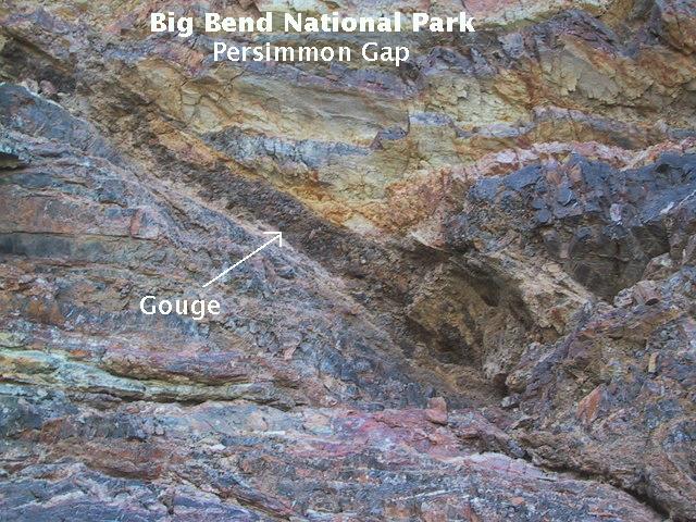
Below: another reverse (?) fault in the Maravillas Chert and more gouge (arrow).
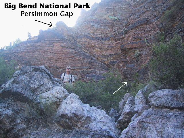
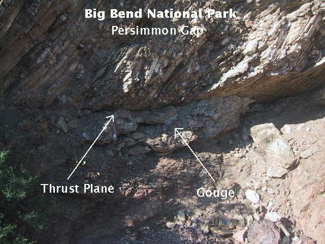
The Persimmon Gap area is the one place in the park where you can see some results of the two major mountain-building episodes that effected the park: the Ouachita-Marathon and Laramide orogenies.
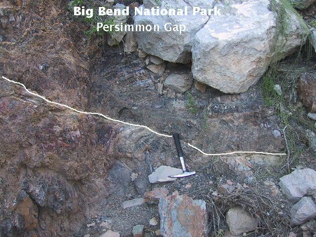
There are two major thrust faults in the Persimmon Gap area, one for each orogeny. The image below may be of one of them, apparently the one that occurred in the late Paleozoic Ouachita-Marathon orogeny, since the rock above appears to be the Maravillas Chert and the rock below Tesnus. (See the interpretave image of Persimmon Peak in the field trip on the Marathon uplift.)
The presence of significant fault gouge indeed indicates a thrusting of the older rock over the younger. Additionally, the fault plane here appears to be close to horizontal (assuming the outcrop is reasonably parallel to the direction of relative motion along the fault), that is, a very low angle reverse (thrust) fault plane. Although there is no specific indication of a thrust fault with the Maravillas above the Tesnus on the USGS map at this location on the southeast side of a hill, it shows the fault trace on the other side of the hill to the northeast of this outcrop. This implies the contact shown on the map between the two formations on the southeast side of the hill is the fault plane.
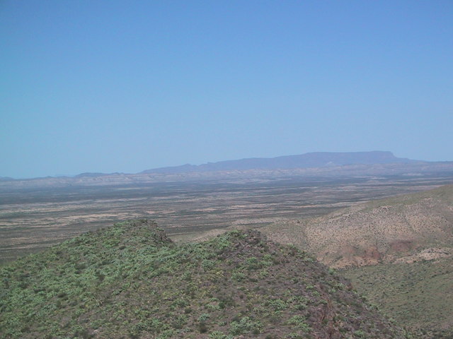
When Randy and I reached what was supposed to be the end of the hike, a minor dispute broke out. The guide book said that if you reach the "saddle" you get a view few people have ever seen. Randy thought the saddle was where you found yourself between two high points - the position indicated by arrow 1 in the topographic figure. I, on the other hand, saw a saddle-shaped mountain that I was sure was the saddle the guide book meant. However, climbing up to the top would be daunting as it was covered with lots of plants having long, painful spines ("vegetables with knives" as I understand a TV golf commentator once said). Randy was convinced we were at the saddle. I dismissed his assessment and headed up the mountain. Afterward, looking at the topographic maps (which we foolishly didn't have at the time of the hike), I think he may have had a point. However, at that time I headed for the saddle indicated by arrow number 2.
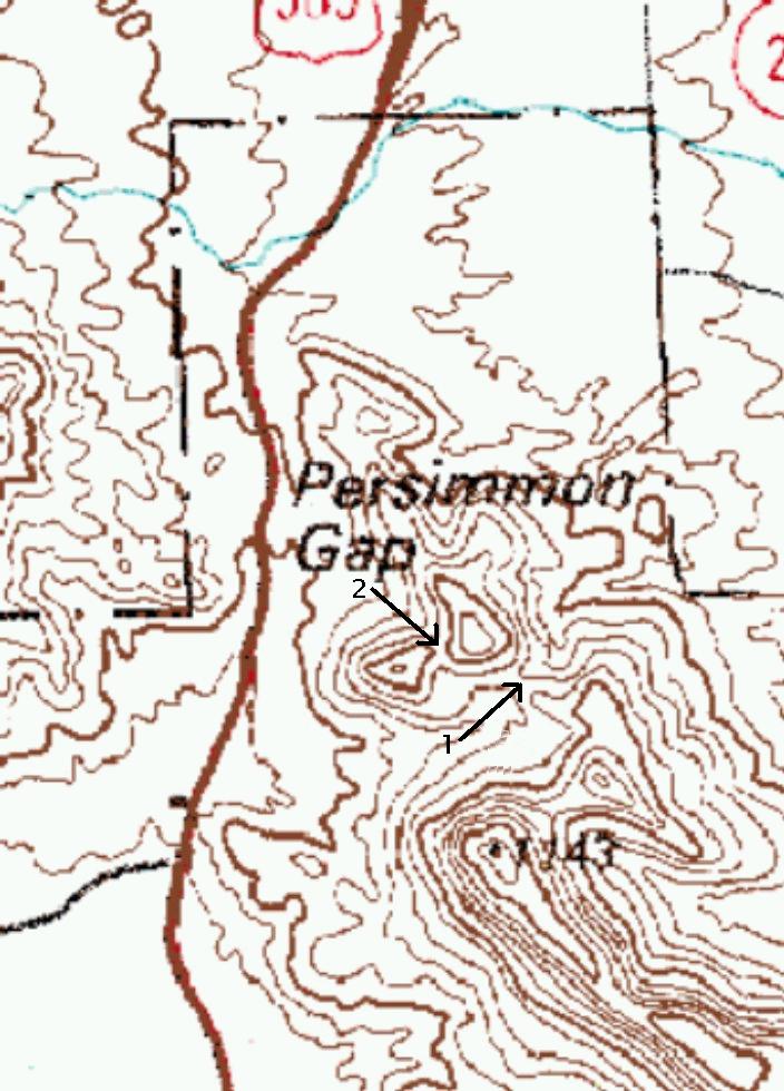
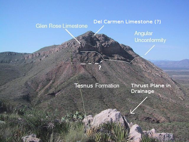
One thing is for sure. You definitely get a much more expansive view from where I ended up, bleeding from numerous cactus punctures (mostly Lechuguilla). I'll have to say it was worth it. Below you see Persimmon Peak, looking south. Refer to the field trip on the Marathon uplift for the geology of Persimmon Peak. One thing. The new USGS map maps the Del Carmen Limestone on top of Persimmon Peak, but I have not seen that indicated elsewhere, not even in the pamphlet that came with the map, so I'm putting a question mark there.
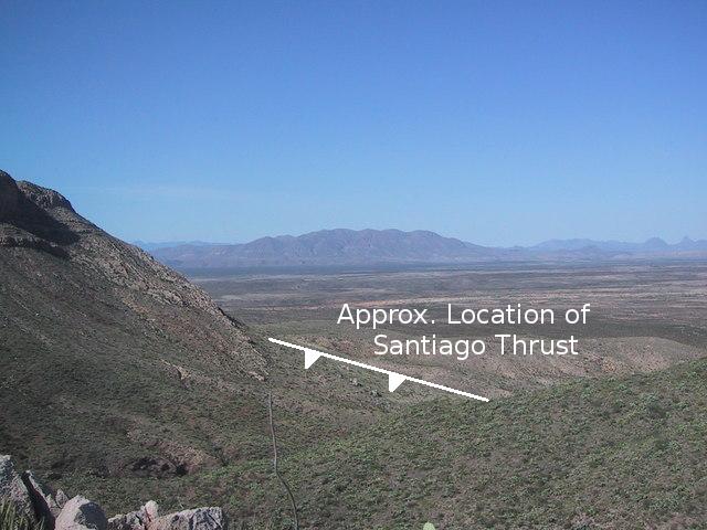
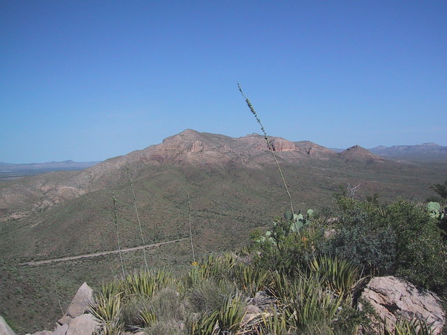
Looking just to the west of Persimmon Peak, your view is across the Chalk Draw Graben. A graben is a down-faulted block of crust. If it subsequently fills in with sediment, it forms a flat, relatively low area as you see here. The "cold front" marks the approximate location of the Santiago Thrust Fault. A detailed discussion of this fault can be found in the Marathon field trip. Along this fault the upper Cretaceous Pen Formation was thrust under the lower Cretaceous Glen Rose Limestone in this vicinity. This thrust fault is younger than the one we found in the drainage, dating to the Laramide orogeny of the late Cretaceous and early Tertiary.
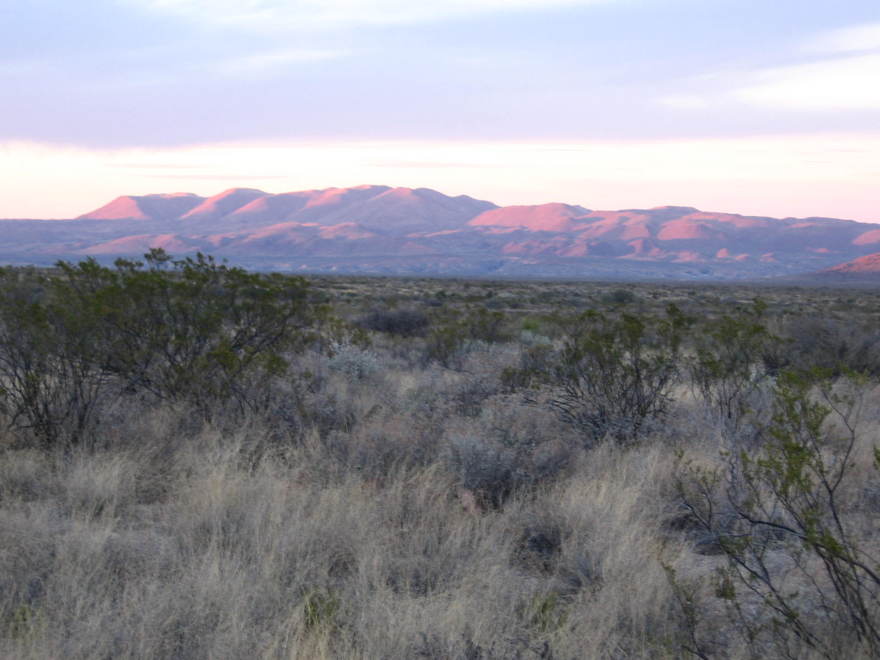
The Rosilloas Mountains in the distance are composed of igneous intrusions of syenite composition. This is rock a lot like granite, but its silicon has been used up to form alkali feldspar before much quartz can form, whereas granite contains abundant quartz.
(On a subsequent trip to Big Bend, Randy took this photo of the Rosillos Mountains at dawn several miles west of Panther Junction.)
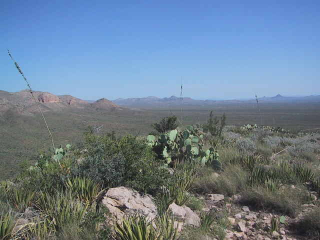
Turning farther to the west, you can make out Nine Point Mesa, composed of intrusive igneous rocks.
Looking to the west, you see Persimmon Gap where U.S. Highway 385 enters (or leaves, depending on your direction of travel) Big Bend National Park. The gap is in the Santiago Mountains, of which Persimmon Peak is a member.
The Santiago Mountains trend to the WNW, separating the Chalk Draw Graben from the Black Gap Graben. In the picture below you see the Santiago Mountains on the left and in the middle of the image, where a ridge of the Santiago range extends to the east from the main trend.
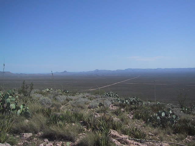
This next picture is looking north along US Highway 385, across Maravillas Flat in the Black Gap Graben. Chalk Draw Graben is within the down-dropped Chisos block, but Black Gap Graben is to the NE of the block boundary. As I've mentioned before, most of Big Bend resides on a crustal block that has been faulted downward with respect to the crust on either side. The Chisos Mountains have been made, not by being uplifted more than the surrounding terrain, but, on the contrary, by the fact they are made of erosion-resistant material and have fared better against erosion than the rocks on the east and west.
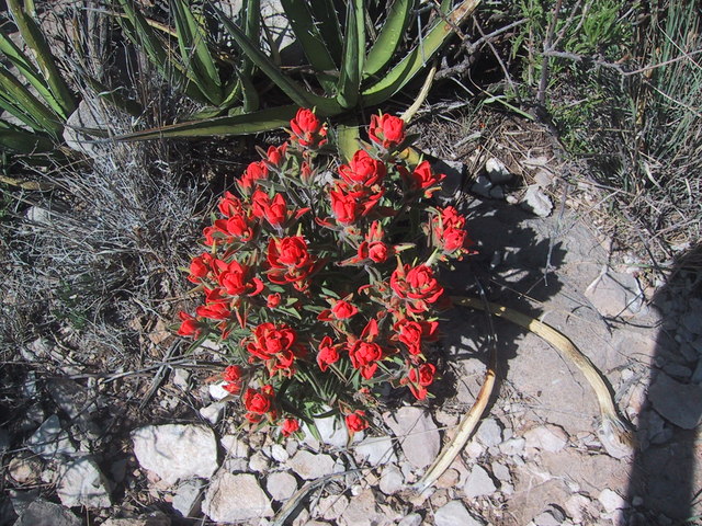
Before we go, we can't help but admire the beautiful flowers blooming in the desert. Here is a particularly gorgeous bouquet of brilliantly red Indian Paintbrush, probably Castilleja rigida (rigid paintbrush). This alone made the difficult climb up to the top of the saddle-shaped mountain worthwhile.
FORWARD to Rancherias Canyon
BACKWARD to Dog Canyon
ALL THE WAY BACK to the Contents