In Search of the Big Blast: East of Talley Mountain
This was the second day of my June, 2016, wanderings through the desert. I might have felt like Moses, but at least I didn't have 40 years less one day to look forward to. And, I'll bet Moses didn't have a cooler filled with IPA. (Actually, I drank very little. You want water in the desert, not beer.) But it was there for whenever I felt hydrated enough – which was only one beer at only one time (sigh).
The original plan was to hike up Juniper Draw to the east side of Talley Mountain. The idea was to find the contact between the Javelina and Black Peaks Formations and then go upward stratigraphically to see if I could find any evidence of what is known as the "K-T" boundary. This boundary marks the time of impact of the asteroid (or possibly comet) in the stratigraphic record that was at least partly responsible for the mass extinction at that time. This event, likely in concert with the eruption of the Deccan Traps in India, took out the dinosaurs, large marine reptiles, flying reptiles, and a lot, lot more.
Often found all around the world at this boundary are tektites (glass spherules formed when magma ejected into the air cools rapidly), iridium (an element rare on Earth but more common in extra-terrestrial bodies), carbon (presumably from fires ignited by hot, ejected material), and shocked quartz. Since the Black Peaks was being deposited from the time of the latest Cretaceous Period (the geological symbol for which is "K") into the early Tertiary Period ("T"), you would think there should be a K-T boundary within that unit, but I'm not aware of any evidence for that. What makes this somewhat more puzzling is that the asteroid struck what is now the northern Yucatan – not that far from Big Bend.
Now, of course I wasn't equipped to discover iridium, but possibly some glass spherules might be found. The problem with the Black Peaks Formation is that most of it is very incompetent. Possibly more incompetent than the person going to examine it. (This is not exactly proper geological speak. A rock is said to be competent if it holds together well. If not, it is not competent, but not incompetent.) Ahem. Anyway, the Black Peaks forms slopes down which debris from higher parts of the Black Peaks and from material above the Black Peaks (if any) collects, mixing with and/or hiding the Black Peaks at the horizon being inspected. It may take a drilling operation to really see if there is any K-T boundary in the Black Peaks. So, I didn't have my hopes up all that much.
I decided to change plans. The weather was just the same as before (hot, no clouds) except there was hardly a breath of wind. Also, my hiking boots had gone belly up the previous day, and I had to make do with sneakers. I looked over my maps to see if I could find a better route to where I wanted to go. It would be a long drive up Glenn Spring Road, but I found a place where I could approach the area from the east. More elevation changes than the original route, but somewhat shorter. The starting point also turned out to be very interesting in its own right.
Time for some pictures. The first one is from the River Road looking north-northeast. The northern edge of Mariscal Mountain with what looks like banded rock is in view. Beyond, on the left, is Talley Mountain. The rock is not really banded. What you see are dipping beds of rock with dark rows of vegetation growing along lines where soil and relatively more moisture is available. The beds dip because Mariscal Mountain is an anticline – where rock has been folded upward.
The dipping beds belong to the Boquillas Formation, San Vicente member. The rock making up this member is of various kinds, but it is probably not too wrong to characterize it as largely shaley limestone and limy shale. It was deposited when Big Bend was covered by a shallow sea in the late Cretaceous (100 to 65 million years ago). In the next picture you can see its steeply dipping beds on the west side of the Mariscal anticline. An anticline is a sort of folded arch of rock with beds dipping away from the axis of the fold (the line of most intense folding) on both sides. The rocks on the west of Mariscal Mountain dip to the west while those on the east side dip to the east. The Mariscal anticline is asymmetrical, because the rocks dip more steeply on the west side than on the east.
Another feature of an anticline is that the rocks in the center of the structure are older than those on the edges. That is, if you were to hike up the mountain from the point in the picture, you would be going back in time, stratigraphically speaking. You would cross from the San Vicente member of the Boquillas into the older Ernst member, then into the yet older Buda Limestone, then the Del Rio clay, and finally into the Santa Elena Limestone of lower Cretaceous age. Imagine folding a stack of different colored papers into an arch, then cutting a horizontal slice through the fold to mimic erosion. You would see the colors placed lower in the stack in the center of the slice.
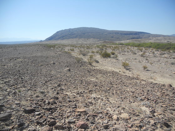
The next photo is where I stopped near the intersection of the River Road with Glenn Spring Road to get a picture of Talley Mountain to the north in the center-left distance of the photo. Much of the material on the slopes of Talley on this side has been mapped as landslide debris. (The latest geological map is Scientific Investigations Map 3142). I would have liked to have made it back that far, but I knew that was probably too ambitious given the conditions. The yellowish-tan rock off to the left forming the low hill is the upper Cretaceous Pen Formation, older than the Javelina and Black Peaks. It is also the rock forming the slope underneath a sill of intrusive igneous rock as labeled in the photo. A sill forms when magma forces its way between bedding planes underground. This particular igneous rock is like that on Cow Heaven Mountain, probably of basaltic composition. Note how the debris derived from the igneous rock darkens the slope, obscuring the color of the Pen. I got a good look at the Pen Formation at Banta Shut-in. There it was altered by the heat of another magma intrusion, but you could still see the mineral concretions characteristic of this unit.
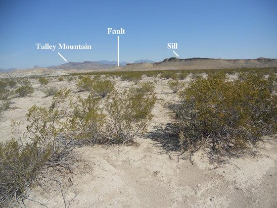
Finally, there is a fault on the left (west) side of the sill-covered ridge where the rock on the far side has moved downward relative to the rock on this side. Since this fault cuts through relatively recent Quaternary sediments, it must have been formed during the Basin and Range crustal extension episode that began around 17 million years ago and continues today, although no significant activity has occurred in Big Bend for two million years.
The southern desert area of the park is the land of major anticlines, all with their axes trending from south-southeast to north-northwest and all due to the compressive forces active during the Laramide orogeny, a mountain-building tectonic episode which affected western North America during the late Cretaceous and early Tertiary. From west to east there are the Cow Heaven anticline, the Mariscal anticline, and the San Vicente anticline. The picture below is of the San Vicente anticline. Only the tip of its nose enters the park, however. This photo was taken looking SE from the River Road as I approached the turnoff to Glenn Spring.
I finally got to my "trailhead" on Glenn Spring Road and parked just off the road on bare dirt. I had not seen a soul since I got on the River Road, but here came a couple of park rangers in an official vehicle. I guess I can't be too surprised they were a mite suspicious of this one guy out in the middle of the stinking desert where no one in his or her right mind would be – unless, of course, he were up to no good. Possibly I shouldn't have pointed out, in pride, my Pakistani shirt. Brilliant white, very loose, it is one of the best things to wear in country like this. ("When were you in Pakistan?") I decided not to reveal I had also lived in Saudi Arabia.
It could be they thought I was one of those ISIS (Da`esh in Arabic) terrorists our esteemed governor Abbott has said are running amok across the border into Texas (a Politifact "Pants on Fire" ruling). Can you imagine Mexicans standing by and watching as these bearded guys cross over the Rio (in boats? Toyota pickups? camels?) sporting Kalashnikov rifles and RPGs? Might they not point that out to authorities? Might not the Border Patrol notice it, for crying out loud? Even if they left their weapons at home (why not; you can buy an assault rifle even if you are on the terror watch list, and fees for extra baggage are high), they would certainly stand out like sore thumbs. (Unfortunately, since the advent of the Trump administration the ISIS terrorists have been replaced by the equally dangerous Mexican murderers, rapists, and drug dealers from Central America.)
I was trying to be cheerful and of good humor. I was asked if I had any firearms in my truck. I said "no", but I just stupidly had to make a joke that I had a Smith and Wesson in my pocket. I gestured with my hand and nearly freaked one of the rangers out. I guess I'm lucky to be alive. "Smith and Wesson makes knives," I explained. "Don't do that!!" the ranger explained. I might have smugly told them I had been coming out to Big Bend well before they were born, but I think at that point my mouth was my worst enemy.
They were, of course, official-like but quite courteous to this desert fool. One even expressed the opinion that he would rather be wearing what I was other than his official uniform. (Why would you be patrolling the desert dressed as if for a Veteran's Day parade?) They said I was parked too far off the road, so I corrected that. And off they went. In my experience park personnel are great! (My first experience with a Big Bend ranger was when I was a young man. He went out of his way to help me. I ran out of gas due to a malfunctioning fuel gauge.)
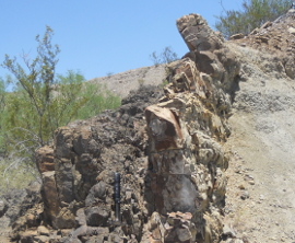
Back to geology I was delighted to find a dike swarm right where I had chosen to begin my trip. A dike results from a sheet-like intrusion of magma moving up through fissures in the earth. If they reach the surface they can produce fissure eruptions like the kind often seen on Kilauea in Hawaii. I had seen these dikes on the USGS geological map, but didn't necessarily expect them to be as interesting as they were. Not far from where I parked there was a small outcrop of a dike. It is shown in the picture below. The first interesting thing I noticed was that the dike appeared to be offset by a fault. The apparent displacement of the dike to the right on the far side of the fault would lead you to believe this was a right-lateral strike-slip fault. (The strike of the fault is its direction along the surface; a strike slip is when the movement along the fault is in this direction; the San Andreas, for example, is a right-lateral strike-slip fault.)
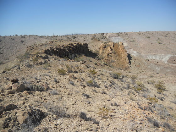
However, the geological map shows no fault here, but there is a fault on the map that runs north-south to the east of this location. The map fault is designated as a dip-slip fault, where the movement is either up or down dip, usually vertical or nearly so. On the map this fault is shown to be down on the west side. I went to Google Earth when I got back to Austin, and there is the possibility that the magma rising from below at this location split into two parallel sheets, and there is no fault here at all. The situation is unclear to me. The picture below is a closer look at the apparent offset of the dike.
Another interesting thing about the dike is the baked rock on either side. The dark material in the middle appears to be basaltic in composition. Basaltic magma is extremely hot, up to 1300 degrees Celsius (2300 degrees Fahrenheit), and can severely alter the rock it comes into contact with, turning it into metamorphic rock. Note the difference between the hard altered rock and the unaltered Javilina Formation (gray material on other side of dike). The Javilina consists largely of clays. The baked rock is likely a form of fine-grained metamorphic rock called hornfels. The volcanic activity that created the dikes here was apparently related to that in the Cow Heaven Mountain area.
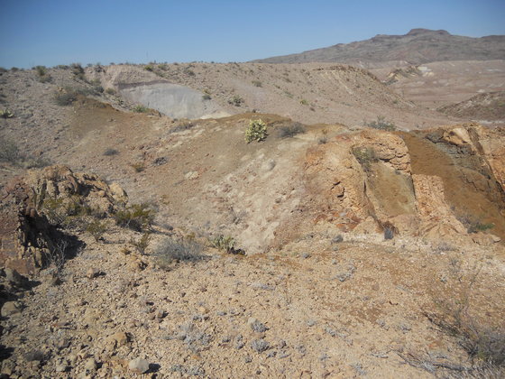
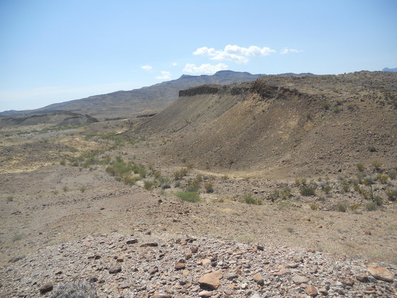
All the dikes I saw in this area were similar: basaltic centers with baked rock sides. The dike in the foreground of next photo is of the same dike as above. It disappeared under debris and re-emerged on the other side of the rim overlooking Glenn Spring Draw. Another dike, crossing the draw, is also seen. The view is toward the southwest with Mariscal Mountain in the distance. The second photo below is of Talley Mountain with yet another dike trending westward in that direction. This dike is broken into segments, parallel but not along the same line. Whether this pattern was caused by faulting or by the magma following preexisting structure, I don't know. The sediment on this side of the draw is the Javelina Formation. On the other side it is the Black Peaks. The contact between the two formations is somewhere in the draw, covered with alluvium (sediment deposited by running water). However, I wanted to find a location where the Javelina-Black Peaks contact was exposed.
So, I headed down into Glenn Spring Draw with the aim of moving south and finding a reasonable location to cross over into Juniper Draw. According the the USGS map, there should be an exposed contact between the Javelina and the Black Peaks just east of Talley Mountain. As I descended into the draw I saw this interesting erosional hole in the dike I was leaving behind.

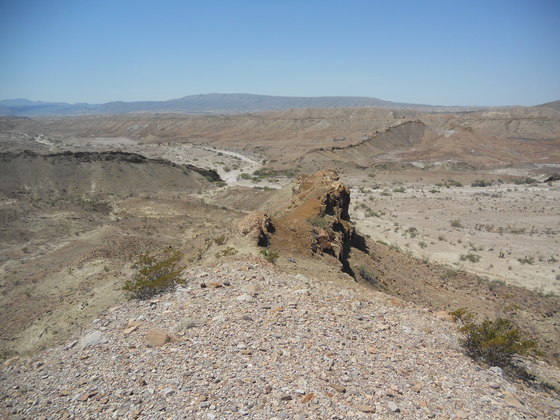
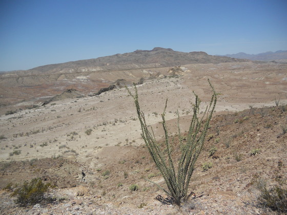
My effort, alas, was thwarted. This last picture is where I finally succumbed to the heat and lack of a breeze. I had to walk slowly in order to generate a minimum of body heat through exercise. This meant I couldn't make the distance I wanted in the time I had. I had plenty of water, but went through it at a pretty good rate. After all, I was almost 72 years old at that point; you have to cut me some slack! The picture below is of another basaltic intrusion where I finally turned around and headed back; this time a sill acting as a resistant cap to protect the softer Javelina material below. The slope is darkened by debris from the eroding cap. (Note the lighter material at the base of the slope.) An average radiometric age of 46.5 million years was obtained for several samples from what appears to be the same sill on the southwest flank of Talley Mountain (as reported in the pamphlet accompanying the USGS map). This would place this volcanic activity in the middle Eocene (56 – 34 million years ago). Having to quit was particularly aggravating, because the contact I sought was probably no more than a mile or so up the narrow drainage seen off to the left.
I could have saved myself much trouble had I known of a road that runs from the Glenn Spring Road, past the south side of Talley Mountain, and thence apparently to a juncture with the River Road near the Mariscal Mine. However the topo maps only show the road reaching as far as Glenn Spring Draw, starting from a point on Glenn Spring Road about a half mile from where I parked, and not at all in the Mariscal Mine area. According to these maps the road was not of use for me on this hike. Had I changed my route before I left Austin, I would have discovered the road on Google Earth.
Unlike the road I found while hiking back to Cow Heaven Mountain, this one is very plain on the satellite images, although it gets harder to find on the southeast side of Talley. By the time I ran across this road, however, I was already well on my way toward my intended destination. I did decide to follow it back. Unfortunately, I missed it as I made my way down a drainage. The road was not evident at that location, even though the drainage was rather narrow. By the time I realized I had missed it, I had gone too far to turn back. Rather, I consulted my maps to find a return route. Had I known about this road ahead of time, I could have intersected it while hiking down the Glenn Spring Draw and followed it toward Talley. Maybe if I ever come out here again...
BACKWARD to Cow Heaven Anticline
FORWARD to Mariscal Mine
ALL THE WAY BACK to the Contents