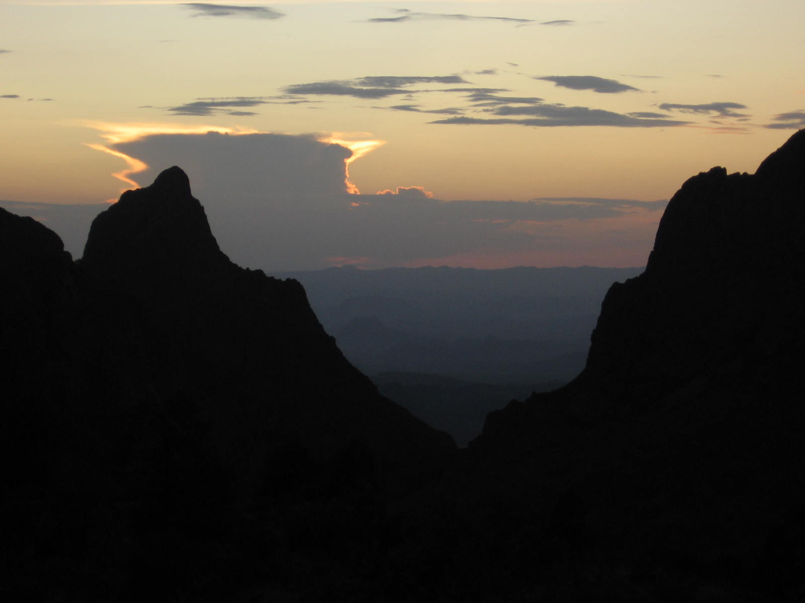
The "narrow escape" here is the one avenue of escape surface water has out of the Basin, a narrow passage in a landform feature called "The Window", through which you can look out over the Chihuahua desert to the northwest from an elevation of over 3000 feet above the desert floor. People gather at a viewpoint near the lodging area in the Basin to enjoy and photograph the spectacular summer sunsets seen through the Window.
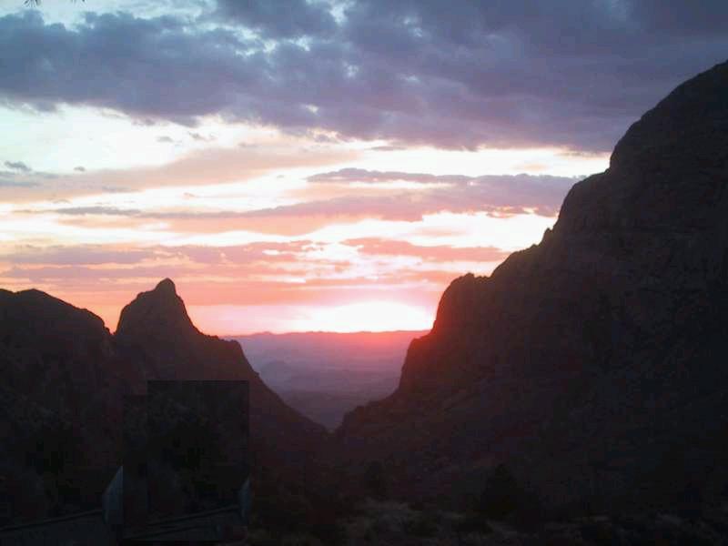
The "Window frames" are Amon Carter Peak to the left (as seen from the viewpoint) and Vernon Bailey Peak to the right. Oak Creek flows (or, usually, not) down to a slender, water-carved slot between these two peaks, which are eroded igneous intrusions. Intrusive rock in the vicinity of the window was dated radiometrically to 32.4 million years. Water in Oak Creek is relatively rare, typically occuring only after an infrequent desert thunderstorm. However, spring 2007 was unusually wet in West Texas, and water was still flowing in Oak Creek in June, despite no rain having fallen for several weeks.
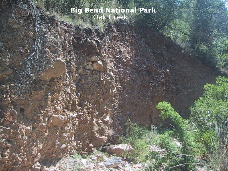
The trail down to the Window pouroff (a pouroff is a usually dry desert waterfall) eventually follows Oak Creek. When water is present, the creek flows through the narrow passage in the rock at the top of the pouroff and falls 200 feet. Creeks erode material along their paths and both deposit sediment and erode and deposit it again as the flow changes speed and direction over time. Water-deposited sediment is called alluvium and there are examples of this along the trail. In the following picture, however, you see sediment that is probably colluvium, sediment weathered from the sides of hills and mountains, accumulating at their base. Some of the clasts (the geologists' general word for silt, sand, gravel, etc.) in this outcrop are fairly well-rounded, meaning either they are products of a fine education or were possibly worked over by running water before deposition. However, the lack of obvious bedding planes and the mixture of many sizes of clasts means this is likely an outcrop of colluvium.
There was no water in Oak Creek at this location, and it was not clear we (my brother Randy and I) would encounter any. Actually, since it had been dry for weeks, we had no expectation of finding running water, and, at this point along the trail, we saw what we thought we would - a dry creek bed.
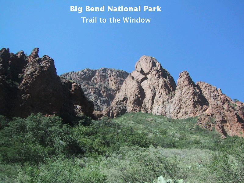
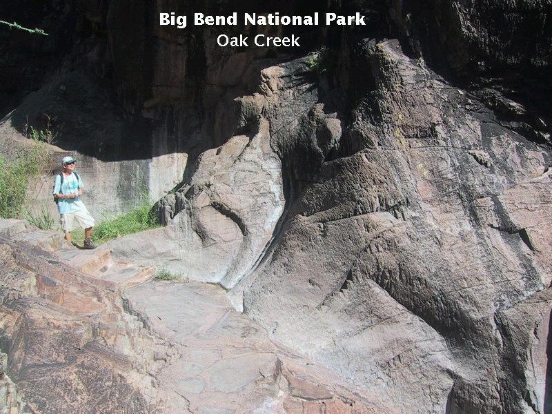
There are many spectacular pinnacles on either side of the trail, eroded from the igneous rock, as you make your way to the Window pouroff. Below you see a view toward Vernon Bailey Peak.
Eventually, the rock becomes more and more devoid of soil cover as slickened and steep rock outcrops crowd the trail. Because of the popularity of this hike, the park service has actually paved and put steps in places where the footing would be difficult. This is seen in the following picture as Randy takes a moment to soak in the scenery.
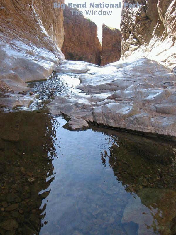
Just when it looked like Oak Creek was going to be bone dry all the way to the pouroff (we did hold out hope for some remnant pools), we came across a beautiful stream of water cascading down the rocky creek bed.
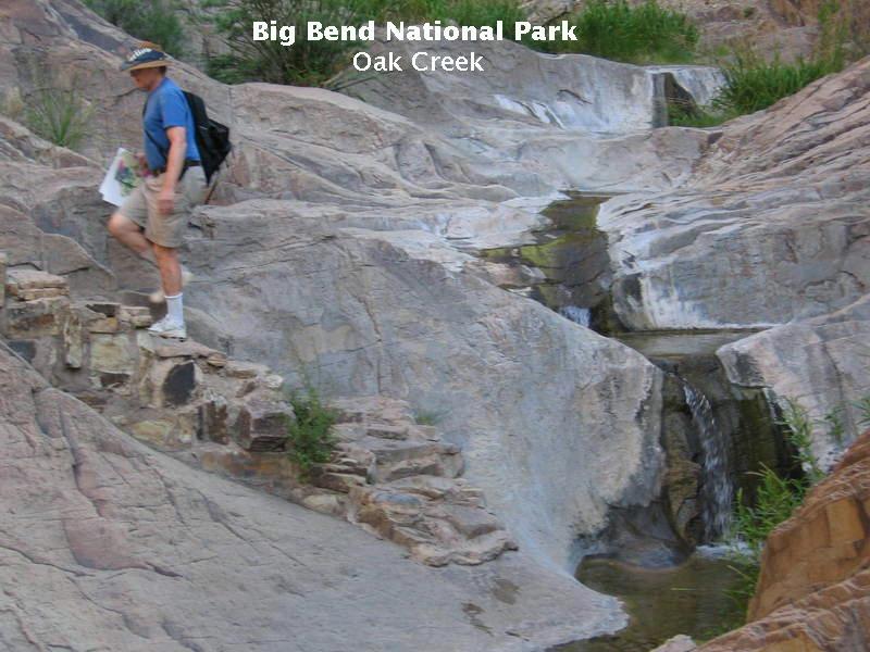
Just where did this water come from? It certainly wasn't present in the bed upstream. It had to come from underground in a process called "base flow", where groundwater percolates out of the ground and into a stream. This occurs where the local water table is higher than the stream bed. In spite of weeks of no rain, there was still plenty of groundwater to supply Oak Creek just above the pouroff.
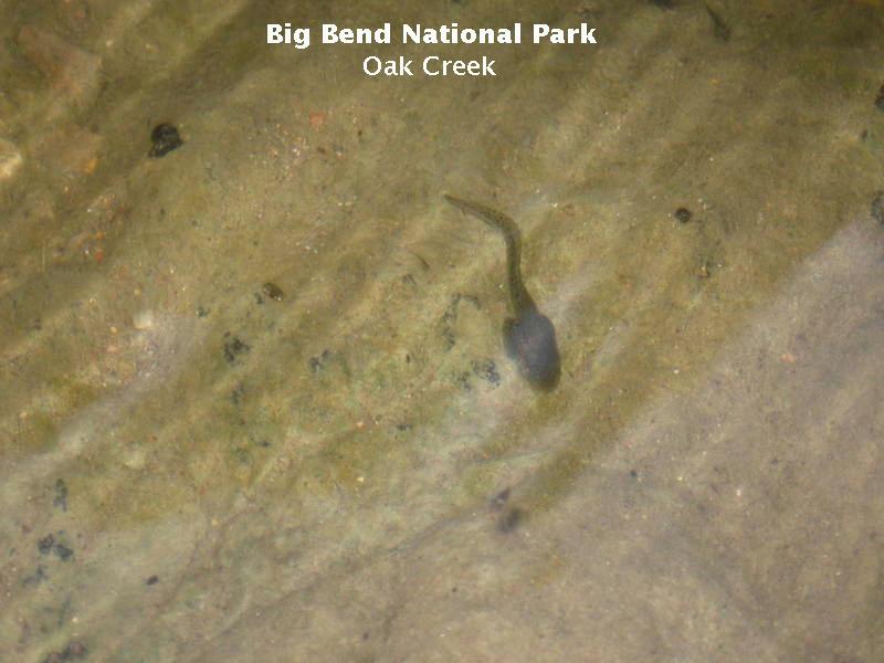
And in the water were some tadpoles, hanging on in hopes of becoming frogs as the water flow decreased day to day. Even after running water disappeared, there would be some pools left for many of these amphibians to complete their life cycle.
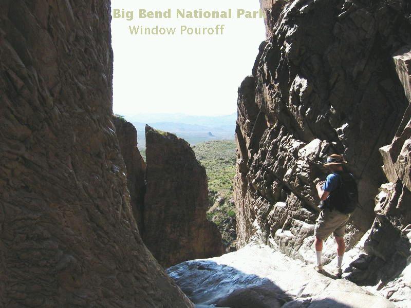
At last you come upon the pouroff itself. An otherwise spectacular view is marred somewhat by spurs of Amon Carter Peak that block much of what you would otherwise see. I'm standing about as close as I dare to the precipice in order to take a picture (which didn't turn out so great). The rock is extremely slick and covered with white deposits from thousands of years of occasional running water. One slip on the uneven footing near the precipice would land you dead on the rocks 200 feet below.
The following image may give you and idea of how slick the rocks are at the pouroff.
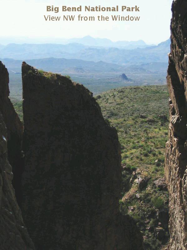
The best view is the following telephoto looking northwest, taken by Randy. The knob-like feature casting a shadow just above the center of the image is Gano Peak, a small igneous intrusion. (Update: At least that was the impression I was under at the time. I don't recall how that impression was formed, but the new USGS geological map shows no intrusion there.) To its left and just a bit higher in the image is a small mesa, on the other side of which is the junction of the West Road with the Maxwell Scenic Drive. At the extreme left, left of the mesa, is the northern margin of Burro Mesa. Little Christmas Mountain is just out of view to the right. All you can see is its southern shoulder.
The rough-looking surface in the foreground is interesting. It is part of a large landslide that occurred on the northwest side of the Chisos Mountains. There are a number of landslides in the park. In fact, much of the ground you walk upon in the Basin to get to the Window is landslide material. Other large slides are found at Talley and Chilicotal Mountains and on the northeast flank of the Rosillos Mountains. The landslides are geologically recent, occurring during the Quaternary Period.
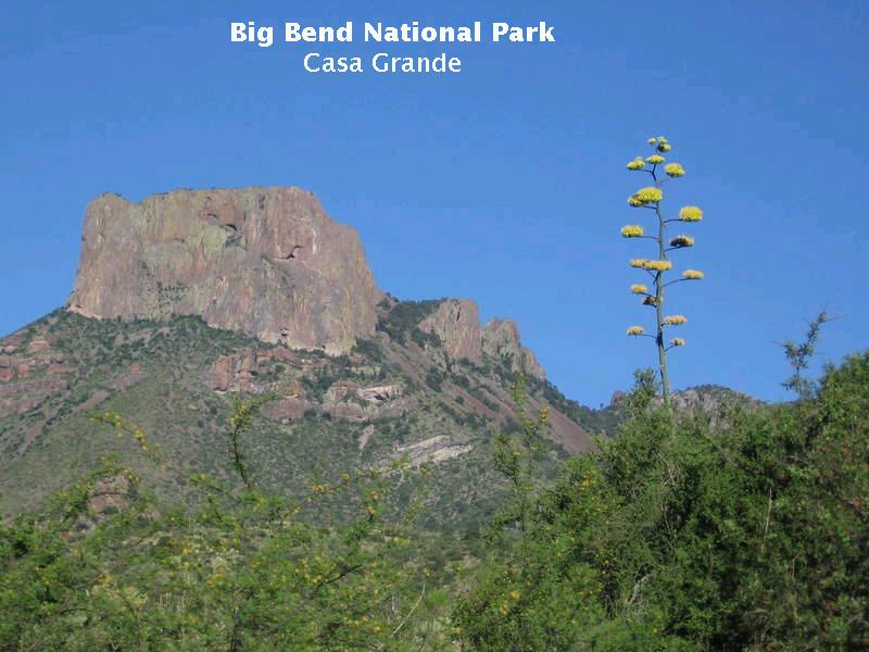
Heading back to the lodging area, you get a spectacular view to the east of Casa Grande in the afternoon sun. It would be verging on sacrilege, therefore, not to include an iconic Big Bend picture featuring this mountain and a flowering agave.
Geologists have to dig beneath the breathtaking beauty of the scenery to find out why it is there, so I close with the following image of the volcanic stratigraphy of Casa Grande. This was not an easy task because the several authors I consulted have slightly different interpretations. McGookey (Geologic Wonders of West Texas) identifies what originally appeared to me to be the Bee Mountain Basalt (34-30 million years in age, consisting of a number of individual lava flows) as part of the Pine Canyon Rhyolite. McCloud (Big Bend Vistas) divides the cliff face of Casa Grande into two halves with upper half being ash-flow tuff and bottom half the Lost Mine Rhyolite. Spearing (Roadside Geology of Texas) identifies layers only as either rhyolite or basalt, with no names.
I had been contemplating a hike up Casa Grande to see if I could decide which, if any, of the above authors had the correct stratigraphy. Fortunately, the new USGS map has done this for me, but has still left questions unanswered. Below is the doctored stratigraphy of the mountain. Some of the difference is due to a change in nomenclature. The suite of volcanic rocks in the Chisos Mountains formerly consisting of (older to younger) the Brown Rhyolite, the Wasp Spring Flow Breccia, the Lost Mine Rhyolite, and the Burro Mesa Rhyolite is now identified as a single formation: the South Rim Formation, consisting of the following members (older to younger): Pine Canyon Rhyolite, Boot Rock member, and Emory Peak Rhyolite. The rocks formerly designated Burro Mesa Rhyolite in the Chisos are now recognized to be separate from that formation, which is confined to rocks farther west in the Burro Mesa area and is a member of a newly named formation: the Burro Mesa Formation. The South Rim Formation appears to be associated with eruptions of the Pine Canyon Caldera, the remnants of which are located in the Chisos to the northeast of the Basin. Neither the Emory Peak nor Pine Canyon members are found in the Basin area.
The rocks that were originally labeled Emory Peak in the photo below are now the Boot Rock member of the South Rim formation, which has been dated to 32 million years old and puts it in the early Oligocene epoch. It consists of ash-flow tuff and lava flows of rhyolite and quartz trachyte as well as volcanic breccia (rock composed of angular fragments). Rhyolite is volcanic rock with a granitic composition. Trachyte is similar but with a low concentration of quartz and higher concentrations of alkali metals.
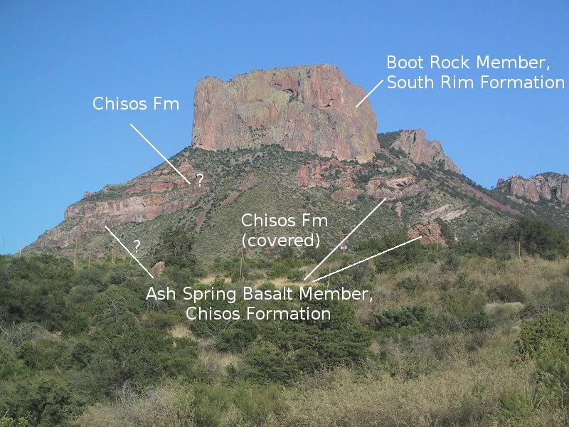
I'm not clear on where the boundary between the overlying Boot Rock member and the Chisos formation is, but I was partly correct in identifying as basalt what McGookey identified as the Pine Canyon rhyolite. However, it is identified as the Ash Spring Basalt member of the Chisos formation (41 million years old, dating to the Eocene epoch), on the USGS map, not the Bee Mountain Basalt as I originally thought. (They are difficult to differentiate in the field as they look similar and are not that different in age, geologically speaking.) These rocks outcrop on the right side of the picture. There are rocks on the left side with the question mark that sure look the same as the ones on the right, but they aren't so identified on the USGS map.
The Chisos formation is mapped between the Ash Spring and the Boot Rock, but I cannot see any definitive boundary beteen the Boot Rock and the Chisos. Also the USGS map says a slice of the Chisos formation lies between the upper and lower basalt layers on the right. No dates of the Chisos rocks were taken in this area, but the ones lying between the two basalt layers must be about the same age as the basalt. The ones above the basalt and below the Boot Rock are younger, possibly Oligocene in age.
As for the rock types seen here, basalt is an iron-rich rock whose lava is typically "runny" (low viscosity), wheras rhyolite and trachyte are richer in silicon and oxygen than basalt with relatively little iron. Their lavas are very viscous and don't flow easily. Tuff is formed when volcanic ash hardens into rock and can exist as either a flow or directly air-deposited. The rhyolite and trachyte (tuff and lava) are resistant to erosion, which is why there are mountains here. The surrounding material as well as much of the South Rim formation has been worn away, but erosional remnants of the resistant South Rim continue to exist.
FORWARD to the Dodson Trail
BACKWARD to the Chimneys
ALL THE WAY BACK to the Contents