Big Mesas Have Little Mesas And So On: Mesa de Anguila I
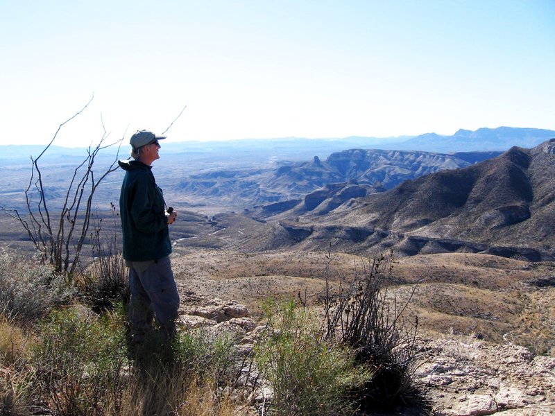
The picture below is of Mesa de Anguila with my brother Randy in the foreground as seen from just outside the town of Lajitas. Large numbers of townspeople, not visible in the picture, gathered to cheer us on and hear Mayor Clay Henry give us a ba-ah-ah-ah-ig send off, after which he and the townspeople toasted us with a beer and left. (Well, to be truthful, no one showed up, not even the mayor, who, by the way, is a beer-drinking goat. We're sure the only reason they failed to show was due to the cold and blustery weather that day.)
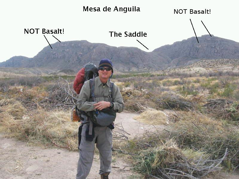
The "Saddle" is a notch in the northwest side of the mesa, formed by a down-faulted block in the plunging anticline of which this part of the mesa consists, where the plunge is toward the camera. The mesa itself was originally formed as a monocline during the Laramide orogeny, a mountain-building event that occurred roughly between 80 and 40 million years ago. The prominent ledges formed by resistant beds are not of volcanic basalt, as claimed in a couple of popular books on West Texas geology, but are resistant beds of limestone. In fact, we couldn't find any evidence of the basalt sills that these references claim intrude the limestone rocks exposed on this side of the mesa, nor are any indicated on the new USGS geological map of Big Bend, Scientific Investigations Map 3142. These references clearly are in error.
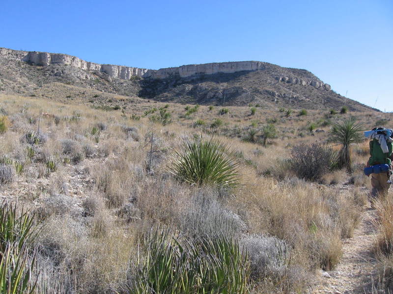
The elevation at Lajitas is 2300 feet and the mesa at the top of the Saddle is 3200 feet. However, the trip up the Saddle itself requires a 600-foot elevation gain over a distance of half a mile. This means you go up about one foot for every four feet of forward movement, an average angle of 15°, not pleasant if you are shouldering a heavy backpack full of water.
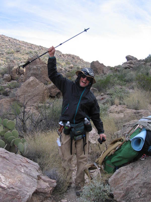
The hike up the Saddle is not without its perils. Reports that terrorists operate in this area appear to be confirmed by the following photo.
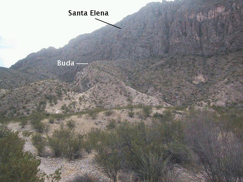
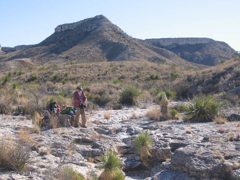
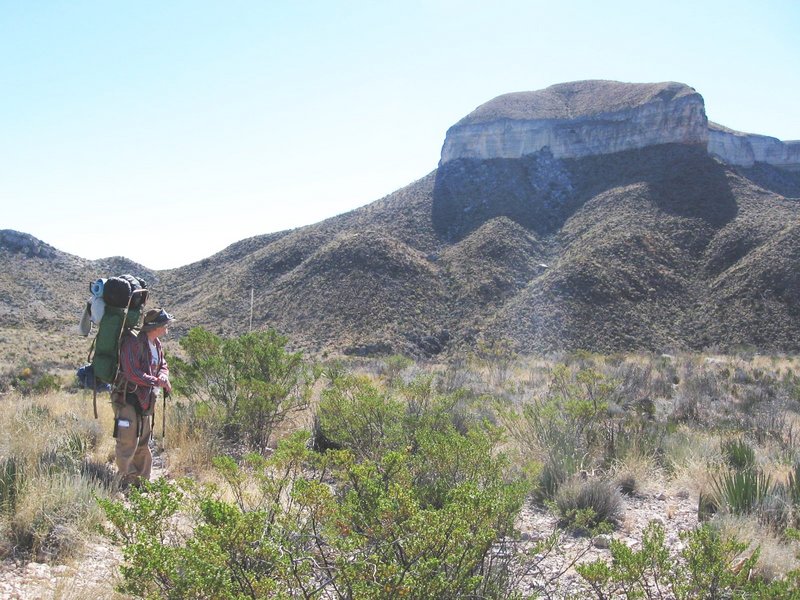
The next couple of pictures were taken as we began our ascent up through the down-faulted block that forms the saddle. Looking to the northeast in the first, you see the cliff of lower Cretaceous Santa Elena limestone, which was formed as a fault scarp that brackets the northeast side of the previously mentioned down-faulted block. In front of the scarp are beds of the upper Cretaceous Buda ("byoo-dah") limestone, within the block, dipping northwest at about 30° (to the left in the picture - the USGS map mentioned above measures 33°). The second picture, looking south, shows the fault scarp in the Santa Elena that marks the southwest side of the down-faulted block, with, once again, the Buda in the foreground.
I was confused by the new geological map of Big Bend National Park in this area, which shows Santa Elena rocks above the northeast side of the down-faulted block dipping to the southwest, when, in the picture below, they certainly appear to be dipping to the northeast. Looking over other pictures I think the answer is that the northeasterly dips are rather localized, meaning the northwest side of Mesa de Anguila is only a slight anticlinal structure in what is otherwise a large monocline.
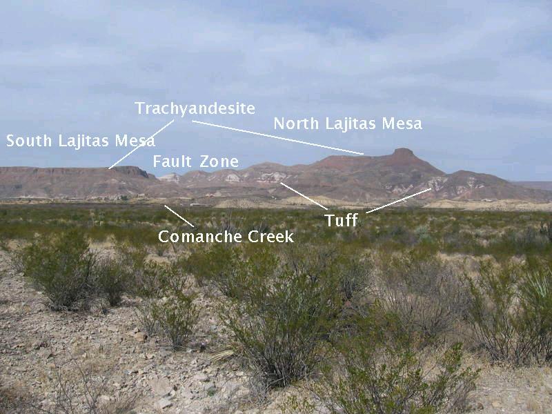
Looking back to the northwest, you can see North and South Lajitas Mesas. These topographical features are outside the national park, so they don't appear on the USGS map. Originally, I followed some authors in identifying the rocks capping the mesas as the Tule Mountain Trachyandesite. (Trachyandesite is a volcanic rock with an intermediate iron composition and relatively abundant alkali metals such as sodium and potassium. Note it is not pronounced "trashy andesite".) However, these rocks almost certainly do not belong to the Tule Mountain unit. For one thing much of the trachyandesite in the western area of the park has been shown to be not Tule Mountain volcanics but rock three million years younger. Secondly, there are no Tule Mountain rocks anywhere close to Lajitas on the USGS map.
Whatever the identification of the rock is (still labeled as trachyandesite in the photo), note that it is higher on the north mesa than on the south. This is due to a fault which runs east-west between the mesas. The light-colored rock is probably consolidated volcanic ash (tuff). If the rock atop the mesas is indeed the younger trachyandesite, it is not considered to belong to the Chisos Formation of Eocene to Oligocene age like the Tule Mountain Trachyandesite. I don't know about the volcanic rocks below it. Comanche Creek (usually dry) flows into the Rio Grande from right to left on this side of the mesas.
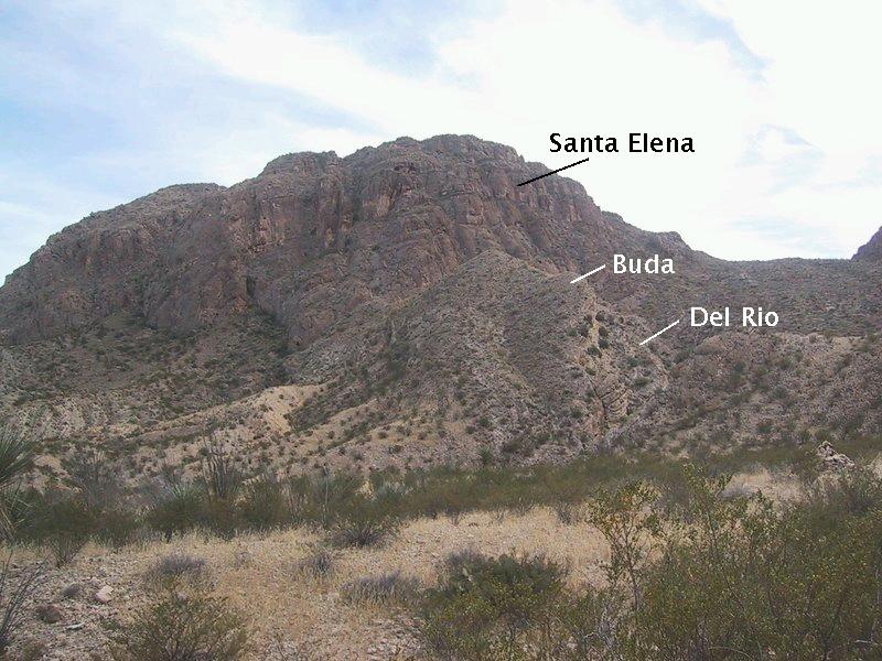
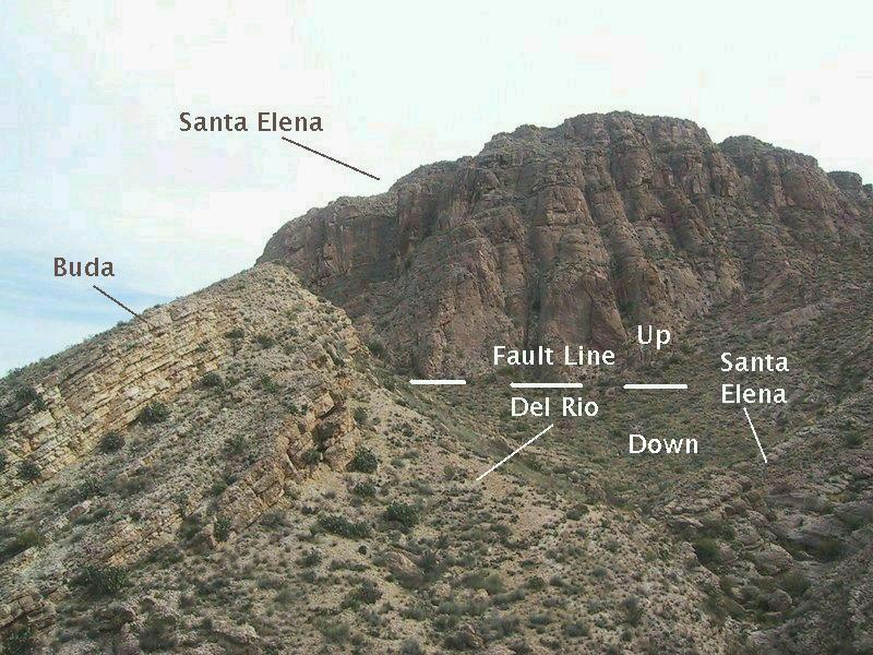
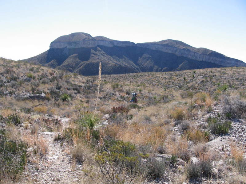
Toward the top of the Saddle, you get a clear view of some of the major stratigraphic units in the area. The Buda lies on top of the Lower Cretaceous Del Rio Clay as indicated. I wasn't entirely convinced of my identification of the exact location of the Del Rio as it appears to be covered with debris. In other parts of the park where it is clearly exposed, it is a distinctive yellowish limy claystone.
The Santa Elena is older than both and therefore stratigraphically lower, but is topographically higher in the distance due to the faulting and, perhaps more importantly, to the fact it is more resistant to erosion. However, it appears below the Del Rio, in its stratigraphically correct position, at the bottom right of the picture.
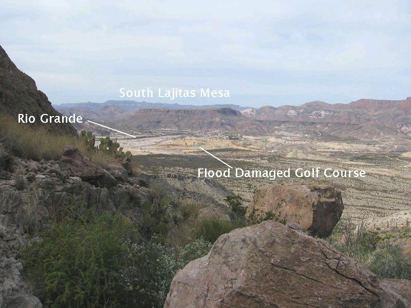
Below is the view looking back toward Lajitas. The flood-damaged golf course can be seen.
According to the National Park Service:
In mid-September, 2008, Tropical Depression Lowell crossed over north central Mexico from the Pacific and dumped extreme amounts of precipitation in the Mexican state of Chihuahua, southwest of Big Bend National Park. A large amount of this rain flowed into the Rio Conchos watershed, the major source of water in the Rio Grande as it flows through the Big Bend. The high volume of run-off in the Conchos over-topped Mexican reservoirs, broke levees, and dumped into the Rio Grande just above the International Bridge connecting Ojinaga, Mexico and Presidio, Texas. The release from the Rio Conchos, combined with heavy local runoff, created the deepest flood in Big Bend's recorded history.Normally 2-3 feet deep, the Rio Grande grew to over 30 feet deep in places and expanded beyond the normal channel to inundate vast areas of flood plain on both sides of the river. For several days the volume of water exceeded 50,000 cubic feet per second, and receded very slowly as reservoirs released water uniformly. This made the flood last much longer than it otherwise would have. The scouring power of the water did damage some infrastructure, but also positively effected the river corridor by ripping out non-native vegetation.
Mesa de Anguila turned out to be a lot more complex, interesting, and scenic than we could have anticipated. From the South Rim of the Chisos Mountains, it doesn't look like much. But when you backpack through it you realize that it isn't just a mesa, but a complex of mesas on top of mesas. These "parasitic" mesas are called "mesitas". The next two images are of the northwest end of the first mesita we encountered on day two of our trip. This mesita is topped at this end with the Upper Cretaceous Buda Limestone. The lower part of the slope slope below the Buda is underlain by the Del Rio Clay. In the first picture I am standing on the Santa Elena limestone. Most of Mesa de Anguila is topped with this limestone, but, above that are the mesitas.
A very impressive mesita is the Mariposa (Spanish for butterfly, since that's what its outline looks like from above). In the photo below (which was, like the above, also taken on day two) you see the northwest side of the Mariposa. The cliff-forming unit is the Boquillas Formation, with the slope-forming basaltic sill below it. (Note: I am assuming it is the Boquillas due to its stratigraphic placement. However, the color on the map looks like that of the Buda Formation. When the Boquillas color overlays contour lines it appears darker, like the color of the Buda.) This sill intruded this Cretaceous rock unit throughout the mesa. I know of no age for this particular intrusion. The closest basaltic intrusion, at Mariscal Mountain, has a zircon uranium-lead age between 46 and 47 million years. Other basaltic intrusions in the park have ages between 28 and 31 million years. (These dates are from the USGS Pamplet to accompany Scientific Investigations Map 3142, 2011.) Note the rockfall below the cliff face resting on the sill below the Boquillas.
Going back in time to look at the Mariposa from a distance (photo taken on day two), you can see that the cliff-forming unit is part of a monocline, dipping to the southwest. A monocline is a geologic fold where beds are folded from the horizontal on one side of the fold axis, to dipping on the other side. Mesa de Anguila (aka Sierra Ponce) as a whole is a larger monocline that formed during the Laramide orogeny as mentioned above. I am a bit confused by the orientation of the monocline depicted in the USGS pamphlet. The dips on the map are to the southwest whereas the pamphlet figure indicates the monocline dipping northeast. (Could be just one of those easily made mistakes that accompany publication. A figure in a paper I authored on a physics topic has coordinate axes oriented the wrong way. Sigh. It happens.)
The "notch" in Mariposa, visible in the image below, is actually where erosion has nearly eaten through the rocks forming the cliffs. The cliffs to the left and right of the notch form the front wings of the" butterly" and are much closer to the camera than the notch. The clear desert air can make judging distance tricky. It appears from comparing photos taken during this trip that the magma that intruded the rocks of Mesa de Anguila varied in thickness from one location to the next. This would imply perhaps a series of laccoliths connected by sills or even multiple layers of igneous intrusion.
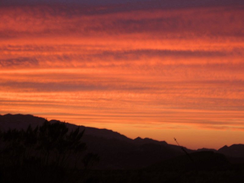
Finally, here is a gorgeous picture of a sunset on Mesa de Anguila taken at the end of the first day. Randy and I were enthralled. We could hardly believe any sunset could be so beautiful. I hope I don't spoil this moment by stating the scientific fact that the high clouds that glow in the light of the setting sun are due to the subtropical jetstream.
BACKWARD to the Mule Ear Trail
FORWARD to Mesa de Anguila II
ALL THE WAY BACK to the Contents