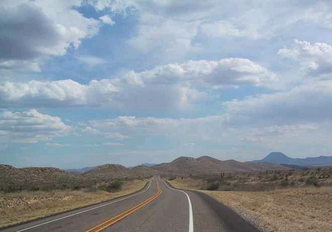
Driving out of Texas' mesa country toward Marathon, Texas, you might think you had made a wrong turn and landed in Arkansas, if you only went by the geology you saw. Paleozoic rocks that are overlain by Cretaceous limestones farther east and therefore out of sight are exposed by erosion as you approach Marathon on U.S. Highway 90. You have entered a window into a much earlier geological time. The rocks here look eerily similar to those of the Ouachita Mountains in southwest Arkansas and southeast Oklahoma.
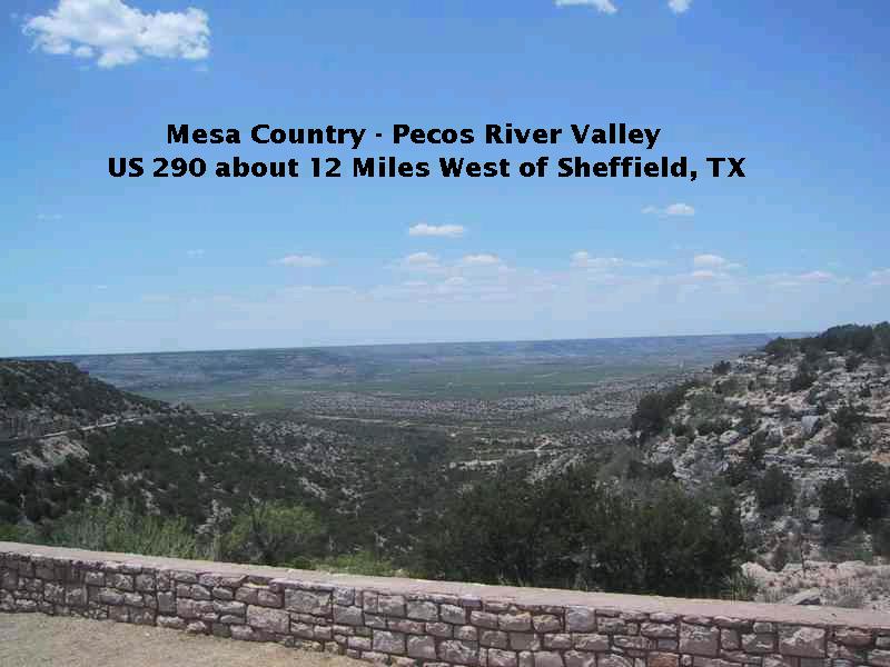
The expansiveness of the Texas mesa country is well-expressed in the above view over the Pecos River valley. All the rocks you see are Cretaceous limestones - there is no hint on the surface of the contorted Paleozoic rocks that lie unseen hundreds of feet below.
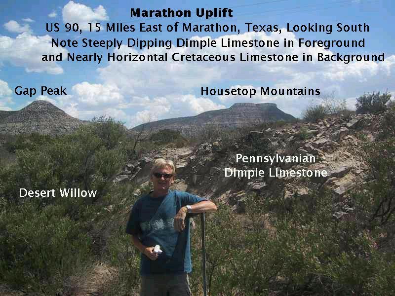
In the above image you see the mesa-forming Cretaceous limestones in the background and the much older Dimple Limestone of Pennsylvanian age in the foreground. The age difference between these rocks is on the order of 200 million years. Although you can't see it in this picture, the nearly horizontal Cretaceous rocks rest on top of the strongly tilted Paleozoic rocks (which include units other than the Dimple Limestone). (See the picture below, which presents the tilting more clearly.)
The Paleozoic rocks were deposited in ancient seas, then deformed and lifted up by mountain building processes, only to be eventually eroded down. Later, the limestones were deposited on top of the remnants of these rocks, which by that time formed the floor of a shallow sea. More mountain building, uplift, and erosion has exposed them to view. (From sea to mountains to sea and back to mountains again. Observations like this convinced geologists before absolute dating methods were invented that the earth had to be extremely old.) Geologists call this relationship where under- and overlying rocks are tilted at different angles an angular unconformity, which always indicates a vast age difference between the rocks below and those above the unconformity - on the order of 200 million years, in this instance, between the youngest Paleozoic rocks and the oldest Cretaceous rocks. In other words around 200 million years of the geologic history on the eastern side of the Marathon uplift are missing.
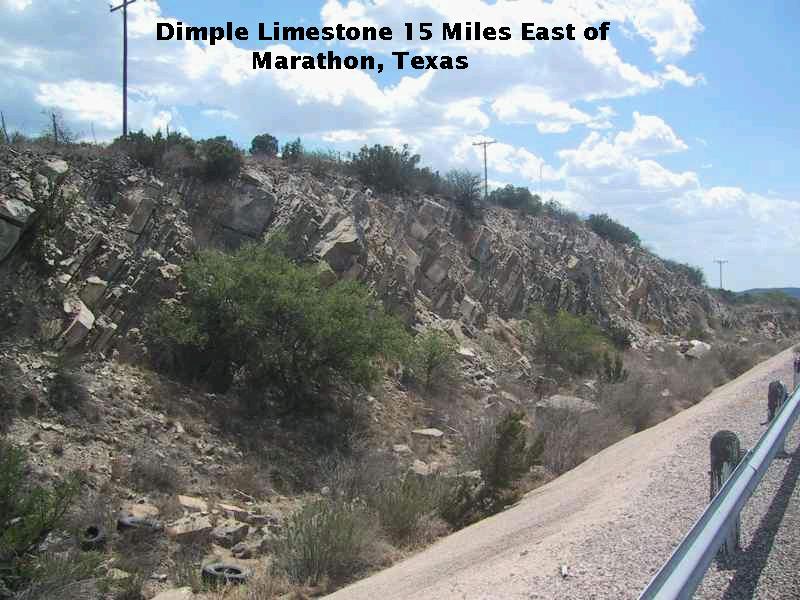
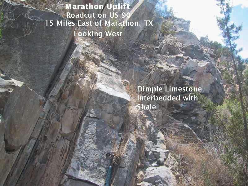
Below you see a closeup of the Dimple Limestone. (Note the rock hammer at the bottom of the picture for scale.) At this location it is interbedded with thin beds of shale, a fine-grained, water-deposited sediment. The shale disappears as you look at younger and younger outcrops of the Dimple Limestone, indicating a loss of sediment source. Eventually, in the upper reaches of the Dimple Limestone, the shale reappears as the depositional environment changes again.
I'm sorry I didn't think to get a good shot of the Pennsylvanian Haymond Formation. We were in hot pursuit of a thrust fault that, according to the geological map I had, should be exposed at a particular roadcut. In trying to locate and identify the thrust fault, I neglected to get a good picture of the Haymond, which is of the same age and lithology (type of rock) as the Jackfork Formation found in the Ouachita Mountains. The picture below indicates what we identified as the thrust fault. To the left is the Haymond Formation, which consists of a series of alternating sandstone and shale beds (as does the upper Mississippian - lower Pennsylvanian Tesnus Formation exposed on the right).
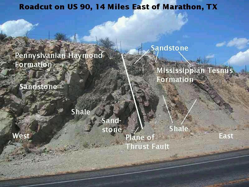
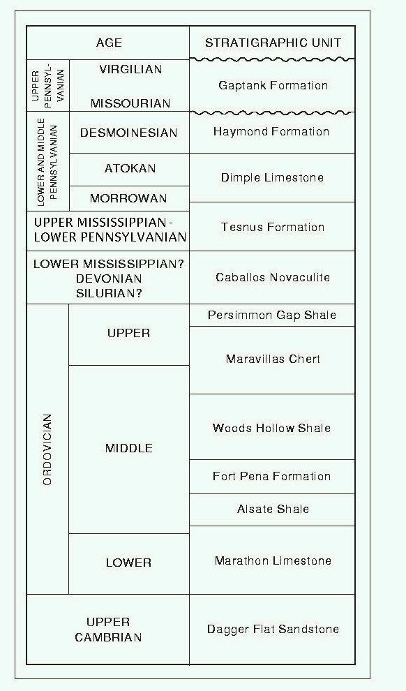
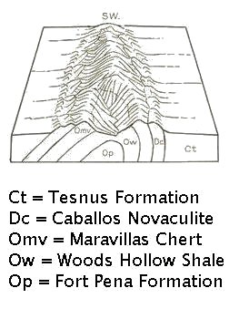
Missing is the Pennsylvanian Dimple Limestone, which lies stratigraphically between the Tesnus and the Haymond. [See the figure below which gives a simplified stratigraphy (how the rocks are stacked) for the Paleozoic rocks of the Marathon region.] The faulting here placed the Haymond and Tesnus in direct contact.
You could probably take the Haymond Formation from its Marathon location and surreptitiously substitute it for the Jackfork Formation in the Ouachitas and no one would be the wiser. They are very much alike. Both consist of alternating sandstone and shale beds. In the roadcut picture above, the sandstone beds are hard and resistant to erosion. The shale beds are darker in color and are recessed, due to their greater susceptibility to erosional forces. Compare with the following image of the Pennsylvanian Jackfork.
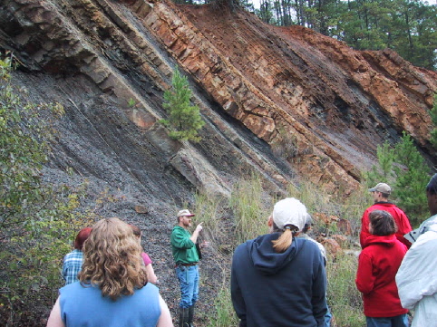
This picture shows Arkansas Geological Commission geologist Doug Hanson speaking to my geology students in front of an exposure of the Jackfork Formation in the emergency spillway of DeGrays Lake, Arkansas. Both the Haymond and the Jackfork were deposited by turbidity currents in a marine basin offshore of what was then a range of mountains that stretched through Arkansas (the ancestral Ouachita Mountains) and extended all the way to at least southwest Texas. Both units consist of alternating beds of sandstone and shale.
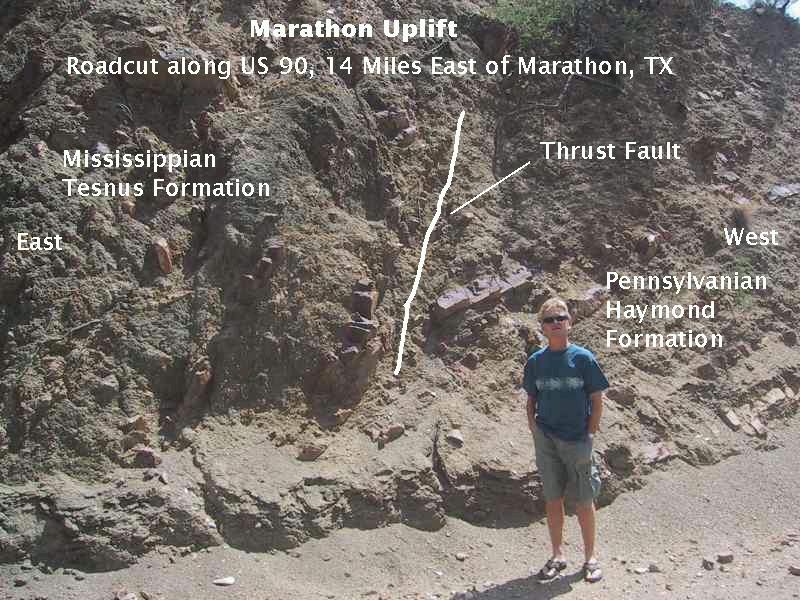
Above you see the trace of the thrust fault on the south side of U.S. 90. The rocks have been chewed up big time by the relative motion across the fault plane. (The fault is easier to make out on the north side of the highway in the image shown previously.) A thrust fault is a fault where, as the name would imply, a bunch of rock is thrust under another bunch of rock. There are lots of thrust faults both in the Marathon uplift and in the Ouachita Mountains. These indicate a lot of horizontal compression occurred in the past. Geological field studies show the compression was associated with mountain building along what is now the southern United States during the late Paleozoic. At that time continental drift was causing what is now northern South America to be shoved toward what is now southern North America. (In those days "southern" North America actually faced east, but North America has rotated clockwise due to continental drift since that time.)
Fast forwarding to more recent times, the following picture of a roadcut along U.S. Highway 90 tells part of the story of what has happened in the more recent geological past.
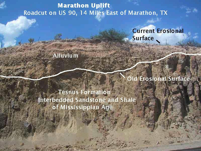
Observe that the beds of the Mississippian-Pennsylvanian Tesnus Formation are nearly vertical. Of course, they were originally more or less horizontal when deposited as sediment. Tectonic (mountain-building) forces have contorted them around to their present orientation. What happened to those parts of the beds that are now missing? Well, they were eroded away, and the erosional surface that resulted is the irregular contact between the Tesnus and the stuff above it. What is that stuff? If you look closely you will see that it is layered, an indication it was deposited by water (alluvium). Hence, there had to be a span of time when the erosion ceased and deposition occurred. Since these are loose sediments, that time was undoubtedly fairly recent, geologically speaking. Now, however, erosion is again working. The layered deposits on top of the Tesnus, which were laid down just in the last few thousand years, are now being eroded. Alternating deposition and erosion means the earth we walk around on is in constant up and down motion (as any experienced surveyor could tell you.)
Putting all lines of evidence together, it is clear that in the eastern part of the Marathon uplift region, the Cretaceous limestones were eroded away, exposing the Paleozoic rocks. The uplift occurred as a result of the Laramide orogeny that began during the late Cretaceous and extended into the Tertiary Period. (The technical term "orogeny" is almost, but not quite, synonymous with "mountain building".) At some point in the recent past the alluvium currently resting on top of the Tesnus was deposited. Several lines of research have shown that a wetter and cooler climate tens of thousands of years ago associated with the last glaciation has transitioned into the current dry climate. Possibly the sediment was deposited then. Presently, this location has become one where erosion is again at work.
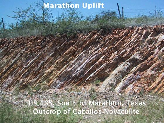
A skeptic might say, "Yes, well, the Haymond and Jackfork Formations are the same age and look very similar, but, after all, sandstone and shale are very common rock types. Why should I believe the Jackfork and the Haymond resulted from the same geological event?" I'm glad you asked that question, because there is a very unique type of rock that is found in both the Ouachitas and the Marathon uplift. It would really be stretching it to deny this makes a strong connection between the two regions. I'm talking about Arkansas/Caballos Novaculite.
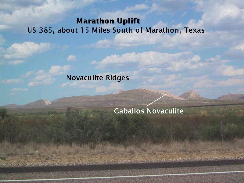
The image above is of a ridge formed by the resistant Caballos Novaculite, which is, as far as I know, indistinguishable from the novaculite that is found in the Ouachita Mountains of southwest Arkansas. In both areas the novaculite, being made of silica, a chert-like rock and therefore very resistant to erosion, forms ridges that stretch above surrounding terrain underlain by less resistant rock. Also, both units are of Devonian age (more or less - the exact age of these units has yet to be determined).
Below you see an outcrop of the novaculite. It does not always come in rather thin beds like this; sometimes it is more massive. In an earlier edition of this virtual field trip, I wondered if this picture was really of the Maravillas Chert rather than the Caballos Novaculite. A subsequent visit has convinced me that this is, indeed, an outcrop of novaculite.
The Caballos Novaculite has, along with the other Paleozoic rocks, been folded into complex patterns, such that it outcrops again and again. Wherever it outcrops, it tends to form ridges like the series of ridges shown below.
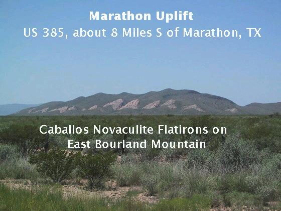
Novaculite's resistance to weathering also results in flatirons like the ones on the southeast side of East Bourland Mountain pictured below. Flatirons get their name from the fact that is what they look like: the flat bottoms of irons. You often find them where you have tilted sedimentary beds that are resistant to erosion.
East Bourland Mountain is an anticline, a geologic fold where the rocks in the center have been raised with respect to those on the sides in a sort of arch. The flatirons are remnants of a continous bed of novaculite which arched across what is now the mountain. Indeed, flatirons of novaculite are found on the other side of the mountain also. The novaculite (along with the also resistant Maravillas Chert, which lies just below the novaculite) has been removed by erosion along the crest of the mountain, exposing less resistant rock (the Woods Hollow Shale - see the figure of stratigraphy displayed earlier) to erosion. This has resulted in a small valley incised in the mountain crest, called an "axial anticlinal valley" (not visible in the image below, but see the drawing after that of East Borland Mountain, adapted from Geology of the Marathon Region Texas, Geological Survey Professional Paper 187, by Philip B. King).
Novaculite is a very hard, flint-like rock that has been used for weapons and tools from prehistoric times. Its genesis is still not clear, other than it was formed in a deep marine environment where very little other sediment was deposited. It could be due to silica condensing out of seawater or to the accumulation of tiny silica shells (tests) or both. Then, quite possibly, further alteration occurred to the rock as pressure and temperature did their work over millions of years of time. The one thing that is sure is that it appears both in the Ouachitas and in the Marathon uplift (and also in Big Bend Ranch State Park).
One (or even two or more) can only conclude that the Marathon area and the Ouachitas contain rocks formed in the same geological setting, a depositional basin that stretched from southern Arkansas to southwestern Texas. In the Marathon area the basin is called, appropriately, the Marathon basin. These rocks were on the edge of the continent and were deformed and faulted when South America got a bit too snug, forming a mountain range called the "Ancestral Ouachitas". Subsequently, erosion reduced these mountains to less than nubbins and the sea returned, depositing limestones. (Two main episodes of limestone deposition occurred - one during the Permian and another during the Cretaceous. The Permian limestones are found on the west side of the Marathon uplift.) Subsurface data indicate this belt of deformed rock, called the Ouachita Overthrust Belt, indeed does stretch through northeast, central, and southwestern Texas into the Big Bend area and parts of Mexico. They are only visible, however, where exposed by erosion.
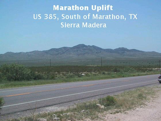
Digression: If, instead of turning south on US 385 at Marathon toward Big Bend National Park, you turn north toward the Glass Mountains and Fort Stockton, you come across a rather boring looking set of hills with a fantastic story. The Sierra Madera may not look like much but they were a puzzle to geologists, due to the evidence the rocks were subject to great disruption. Eventually, evidence was uncovered that the rocks had undergone tremendous pressures, and it was proposed that the Sierra Madera was actually the lower part of an impact zone. A large meteroid apparently struck here, creating a huge crater. Since that time the crater has been eroded away, any remnants of the meteorite have been eroded away, and all that is left is the deformed rock below the level where the meteorite came to rest (unless it disintegraed upon impact). So far this interpretation has stood the test of time. Since the youngest rocks involved in the impact are 100 million years old, the impact was younger than this. Could this impact have been associated with the impact event in the Yucatan that caused the Earth's second largest mass extinction 65 million years ago? Hmmm. The Sierra Madera are shown below.
We drove into Big Bend National Park through Persimmon Gap, which marks the southern end of the Marathon uplift (at least on the surface). It is here you can see a spectacular example of the trauma the rocks in this region have suffered during the two major mountain-building events: the Ouachita-Marathon and Laramide orogenies. The picture below of Persimmon Peak forms the basis of a good (actually difficult) exercise in the use of relative geological dating techniques. Originally in this particular field trip I presented an interpretation taken from various sources, particularly Roadside Geology of Texas, by Darwin Spearing and Big Bend of the Rio Grande by Ross A. Maxwell. There is now a new interpretation based on the recent work of the United States Geological Survey (USGS) in the new USGS map (Scientific Investigations Map 3142, 2011) and on the authors they reference. The two interpretations have major similarities. I thought I had lost the original photo, so the image I had here before was really messed up due to changes made. The following is the best I can do with the new USGS map and the revised image.
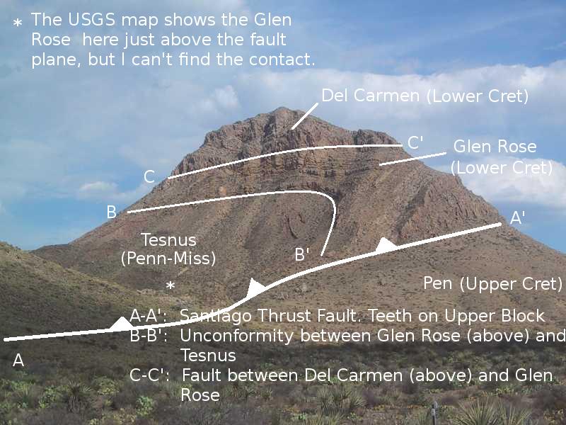
First note the line A-A'. (If this sounds too much like high school geometry, please forgive me.) Below it are upper Cretaceous sediments, the Pen Formation in the vicinity of 80 million years old. Above it is the lower Cretaceous Glen Rose Formation on the order of 140 million years old. (Also the new USGS map implies the top of Persimmon Peak consists of the Del Carmen Limestone lying on top of the Glen Rose, although their figure of the mountain does not show that.) However, the "principle of superposition" in geology states that the younger beds go on top of the older beds, which just makes common sense. So how did the older Glen Rose get on top of the younger Pen? Now can Mother Nature pull a magical stunt that would make the most talented magicians jealous, like putting a sheet on a bed by sliding it under a blanket? It sounds screwy, but "yes, she can."
Closer investigation reveals that A-A' is a fault; in fact, another one of those thrust faults described earlier. The "cold front" symbolism used by geologists indicates that the Upper Cretaceous Pen (limy clay with some chalk and sandstone) has been shoved beneath the Lower Cretaceous Glen Rose Limestone (approximately to the northeast - the view is southeast). OK, how about another geological principle on relative dating: the principle of cross-cutting relations - "older features are cut by younger features". Once again, common sense: The butter has to be there before you can cut it with the butter knife. This fault cuts through both 140 and 80 million-year-old rocks. It must therefore be younger than both. Called the Santiago thrust, it occurred during the Laramide orogeny.
The folding that occurred as indicated by the B-B' line is a drag fold [search for "drag" in the preceding link], caused by the relative motion along the thrust fault. The beds above the fault were dragged to the northeast with respect to the beds below the fault and deformed. Now, what about B-B'? It marks a boundary between 140 million-year-old lower Cretaceous rock (Glen Rose) and the Carboniferous Tesnus Formation. The Carboniferous Period (comprising the Pennsylanian and Mississippian Periods in North America) lasted from about 360 to 300 million years ago, so there is at least a 160 million-year gap in the geologic record here. This boundary is called an unconformity, an angular unconformity in fact, where the beds of the rock above and below are not parallel. This unconformity can be better viewed in the Persimmon Gap hike. Finally, the curve C-C' marks a fault between the Del Carmen and Glen Rose Limestones. The Del Carmen has been faulted downward with respect to the Glen Rose.
In the original interpretation, which was formerly presented in this feature, B-B' was said to be another thrust fault, this one due to the Ouachita-Marathon orogeny where the Tesnus Formation was thrust under older Ordovician to Mississippian period rocks, including the Maravillas Formation. However, the rock formerly identified as Maravillas is now thought, as a result of recent work, to be the Tesnus, which makes B-B' just the contact between the older Tesnus and the younger Glen Rose in the drag fold as explained above. Instead, the surface trace of this thrust fault appears on the left (northwest) side of the mountain whose southeast slope appears on the left side of the photo.
Howbeit, on the Persimmon Gap hike, which followed the drainage upward between Persimmon Peak and the mountain just to its northwest, mentioned in the previous paragraph, my brother, Randy, and I found the contact between the Maravillas above what appeared to be the Tesnus, and this contact was indeed a thrust plane. Hence it appears the thrust plane thought previously to be along the line B-B' in the Persimmon Peak photo is actually in the drainage to the northwest of Persimmon Peak, although it is not designated as a fault plane on the USGS map. (This could be just a problem of map symbolism, since it is unclear to me how one would represent the thrust here given the "cold front" type thrust-fault symbolism used.)
I speculate that earlier investigators identified the contact between the Tesnus and what was thought to be above it (the Marvillas Formation) as the continuation of this fault plane to the southeast. However the fault plane is actually located to the northwest in the drainage. This means the Mississippian-Ordovician rock on the USGS map to the northwest of Persimmon Peak is an erosional remnant resting on the plane of the thrust fault. This erosion would be part of the predominant process of erosion in the park during the Permian, Triassic, and the Jurassic periods. Permian through Jurassic rocks are not found in the park and, in fact, Jurassic rocks are almost entirely absent in Texas, with only relatively small exposures in far west Texas along I-10. (I hope recent readers have not been totally confused by the fact that I've changed the interpretation of the Persimmon gap geology several times as I have pored over my notes, our photos, and the new USGS map. I sure as hell hope I finally have it right now!)
Field studies have led to the following interpretation of what you see on the mountain. The thrust fault between the Mississippian-Pennsylvanian Tesnus Formation and the older Ordovician-Mississippian rocks was active during the Ouachita orogeny at the end of the Paleozoic and shoved the younger Tesnus under the older rocks from northwest to southeast (back then it was more like southwest to northeast due to the changing orientation of the North American continent). The uplifts that accompanied and followed the Ouachita mountain-building episode led to erosion that removed all but remnants of the Maravillas and Tesnus Formations, on top of which the lower Cretaceous limestones were deposited in a shallow sea.
Later, the sea retreated (uplift and/or lowered sea level, resulting in erosion) but returned in the late Cretaceous to deposit more limestone. That limestone has been partially removed by erosion during the last several million years, but before that a thrust fault associated with mountain building at the end of the Cretaceous and beginning of the Tertiary, the Laramide orogeny, shoved the upper Cretaceous Pen Formation in this area to the northeast under the Tesnus, Maravillas, and lower Cretaceous limestone.
A fellow reading this entry (an earlier version) emailed me to say that his geology field course involved his professor dumping the class off here and telling them to map the area for their field credit! What? Have undergrads map this messed up geology? Now, ya'll know thet just ain't raht! Another person described two geologists getting into a heated argument over the Persimmon Gap geology during a field trip. (Luckily, congressional political divisions have yet to get involved.)
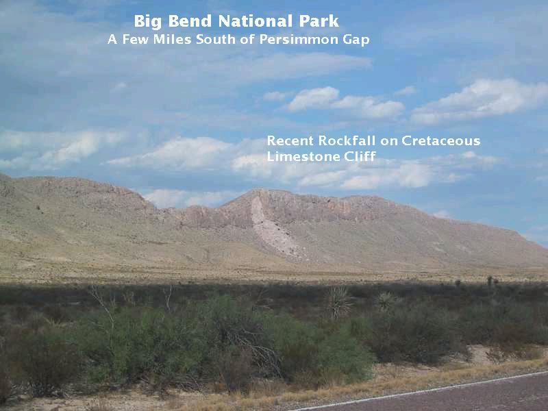
To bring this section to a close and to show nothing is forever (not even diamonds if the proton decays), here is a picture of a recent rockfall that can be seen after you drive through Persimmon Gap. A rockfall is a type of "mass wasting", erosion caused by gravity without the (immediate) help of water, wind, or ice (although one or more these may have had a hand in making the mass-wasting event possible by producing slope instability). This fall is on a small mountain just north of Dog Canyon. The scale of the picture is deceiving; it's a lot bigger than it looks. The fall occurred in 1987 and was heard for miles, according to the National Park Service Website. Erosion in the form of rockfalls, landslides, desert flash floods, etc., continues to sculpt the terrain of southwest Texas.
Footnote: You may have noticed a marked difference in the vegetation in some of the images. We drove back through the Marathon area a year after the original pictures were taken, and the light was better for some of them, so I retook some pictures. Also, this was the year Texas received so much summer rain. The year before, this area was in the grips of a serious drought. After the drought-breaking rains, West Texas was incredibly green, as I've never seen it before.
FORWARD to the Grapevine Hills Trail
BACKWARD to the Edwards Plateau
ALL THE WAY BACK to the Contents