As I understand it, degradation of this area by humans eliminated all the grapevines that gave these hills their name. This is, unfortunately, a common situation in the Big Bend area, which apparently used to be much more amenable to human habitation. The problem seems to have been mostly overgrazing by early ranchers. Fortunately, the rocks remain, and in these hills weathering and erosion have created a truly grotesque landscape - a terrain that should be on a planet other than Earth.
Update: I recently read the book, In the Shadow of the Chinatis by David W. Keller. In this excellent book the author describes why the area around Pinto Canyon, about 100 miles to the northwest, became so barren. During the 1940s there was generally a greater than average rainfall enticing ranchers to build up their herds to numbers not sustainable when the rain decreased. And decrease it did as a devastating drought hit the region in the 1950s. (I recall as a kid the time in Dallas when you couldn't see across the street for the dust.) The herds took a disastrous toll on the stressed vegetation, and the ranchers did even more damage trying to save them. Thousands of animals died or had to be sold off. Ranching as a way of life pretty well came to an end.There was an additional problem for the area that became the national park. Because ranchers were bought out to establish the park, they were given several years of free grazing before they had to wrap it up. The story seems to be that they typically loaded the land with animals to make as much money as possible before they ceased operations. This apparently did a great deal of damage to the environment. This was in the 1940s. Then the 1950s drought hit, which no doubt made things worse, but at least there was no more grazing.
Update to the update: I just read another book, this one by J.O. Langford, Big Bend: A Homesteader's Story that sheds some more light on the degradation of Big Bend. According to him, after he was forced to leave his homestead at Langord Hot Springs due to the revolution in Mexico, World War I sent the price of livestock soaring, and ranchers loaded up the land with stock. When he was finally able to return in 1927, he claimed all the lush grass he recalled growing in the area had been grazed off. The land had changed drastically and was now a desert. Most of the Mexicans who had been farming and ranching along the border had left.
Before you hike (virtually speaking) up the draw the trail follows, check out the view northwestward toward the Rosillos Mountains below.
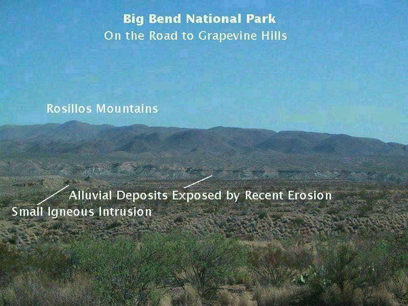
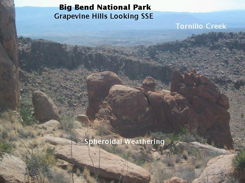
In the distance you see the north bank of Tornillo Creek. The layered structure in the side of the bank shows it consists of previously deposited sediments derived from the Rosillos Mountains to the north. This sediment (alluvium) was deposited over the past several thousand years, but now, possibly due to either a decrease in rainfall (and concomitant decrease in vegetative cover) or an increase in overall elevation (or both), it is being worn away. Besides the alluvium the Black Peak Formation outcrops on the other side of the Tornillo Creek, but it's hard to distinguish different units from this distance. The Black Peak was deposited from the late Cretaceous to the early Tertiary.
The dominant regime of the Big Bend area is one of erosion, so the deposition of alluvium in the arroyo's banks is but a glitch in the overall trend to wear down the landscape. Also seen in this picture is a small igneous intrusion, probably just the tip of a larger body of intrusive igneous rock that resides mostly subsurface. According to the recent USGS study of Big Bend geology (Scientific Investigations Map 3142 and USGS Circular 1327), this is an intrusion of basaltic composition, but no age has been assigned to it other than it dates to the Oligocene or Eocene.
As you stroll up the easy trail you are increasingly surrounded by these odd roundish oblong rocks that extend all the way up the ridges on either side. It is almost like being in a stadium or coliseum with all these rock spectators watching you make your way up to the Head Rock (who lives at the end of the trail - more about him later). Below is a view seen early on in the hike.
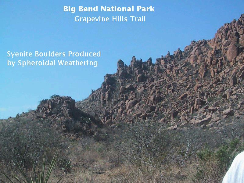
What is responsible for these strange rock shapes? First of all, the Grapevine Hills is an igneous intrusion called a laccolith (a mushroom-shaped body of igneous rock) exposed by erosion due to its greater resistance to weathering than the surrounding rock. The Grapevine Hills laccolith is about 3.5 kilometers wide and 200 meters thick, according to the USGS study. Secondly, the rock was broken up into compact-car sized (more or less) chunky pieces as it cooled and shrank. (A basic thermal property of most solids is that they expand when heated and shrink when cooled.) The shrinkage caused the rock to pull apart into those chunky pieces, which have weathered into the shapes seen.
In the above picture you can see the fracturing patterns that have allowed access by water and air into the rock, accelerating the weathering. These fractures are called joints. No relative motion has occurred on either side of these fractures. Otherwise, they would be faults.
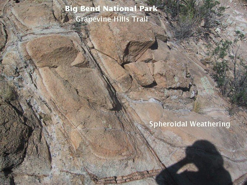
The draw up which you are walking sees occasional flash floods due to desert cloudbursts. These floodwaters carry along sand and gravel which acts like an abrasive to wear away the bedrock. However, in many places there is something quite bizarre about the exposed bedrock. I'm talking about strange patterns like the ones in the image below, which was taken from above, standing on a tall boulder.
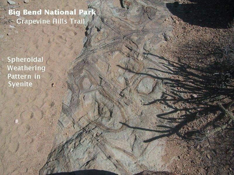
It took a few seconds of thought, but the origin of these patterns quickly became clear. You are looking where the erosional surface has cut through the bedrock, exposing the jointing pattern. The discoloration is from water and the chemicals dissolved in it seeping into the joints and reacting chemically with the rock. This is the first step in producing the "rock spectators" that line the trail.
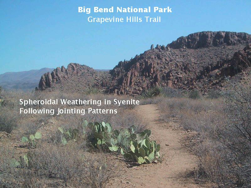
A bit farther up the trail, the same patterns are seen in the rocks on the hillsides (below).
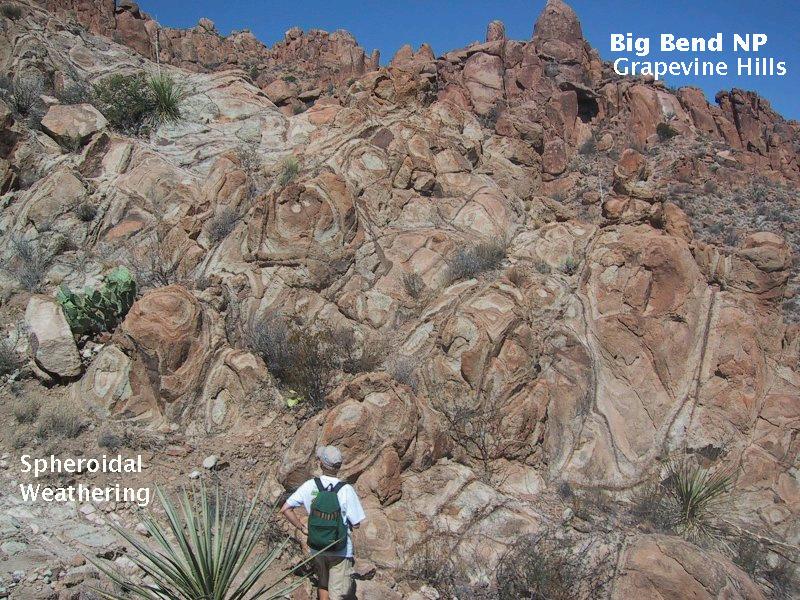
This type of weathering, where water seeps down into rock and weathers it into rounded shapes is called spheroidal weathering, and the Grapevine Hills are a veritable celebration of this process. Not in person nor in pictures have I ever seen spheroidal weathering so clearly exposed and on such a scale. Below are three more pictures of spheroidal weathering. (The redundant captions are due to these pictures being prepared for use in the geology class I taught.)
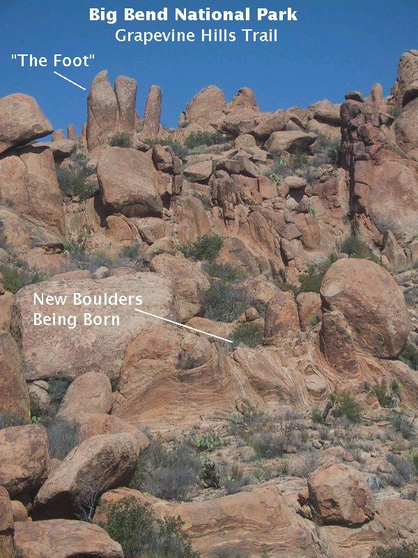
The first photograph is a closeup of the weathering pattern exposed on a boulder. The second shows the process of exfoliation, giving birth to new "spectators". (Exfoliation is where layers of weathered rock peel off, sort of like peeling an onion.) Toward the top of the picture you see a boulder pattern we dubbed "The Foot". The third is a closer picture of the exfoliation process. (The last two pictures were actually taken near the end of the trail.)
I haven't mentioned the type of igneous rock that makes up the Grapevine Hills, although it is in several of the images. Syenite is a fairly rare type of igneous rock, related to granite. However, in spite of the close resemblance, you shouldn't take it for granite (ha! ha!), because syenite, unlike granite, contains little or no quartz. (Not realizing the rock was syenite during the hike, I mistook the veins of whitish minerals for quartz until I put my finger on a vein and had the crystals cleave off into my hand. At that point I knew they were not quartz, since quartz does not exhibit cleavage. A little dilute HCl proved the crystals were calcite, which probably crystallized out of groundwater in the joints.)
Syenite is found in continental settings where the magma is high in potassium, other alkali metals, and aluminum; in syenite the silica (silicon and oxygen) gets used up in making feldspars, primarily potassium feldspar (also known as orthoclase), such that little is left over to form quartz. According to the USGS study mentioned previously, this Syenite dates to 32 million years ago, which would put it in the early Oligocene Epoch. At this point you have gone far enough up the trail that you might pause and look back over the draw up which you came.
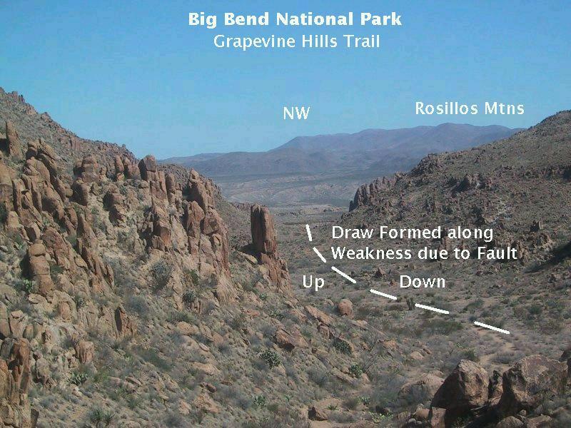
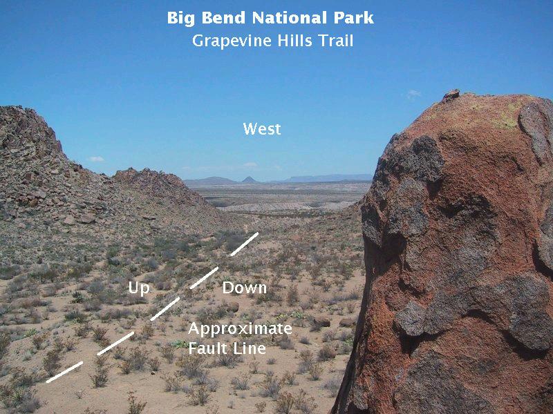
In the distance you see the Rosillos Mountains, which is also the surface expression of an igneous laccolith of syenite composition. Larger than the Grapevine Hills laccolith, it is up to 10.5 kilometers wide and over 600 meters thick at its thickest point. There really isn't anything in this picture to give a reason for the existence of the draw at this location, but a northwest-southeast trending fault, out of sight due to the alluvial covering, does run through the Grapevine Hills laccolith at this point - one of several parallel faults that do so. It is along this fault that erosion has been accelerated, forming the draw. Later in this virtual hike, I'll show you some evidence of the existence of this fault. Note that the motion has been up on the southwest and down on the northeast (as claimed by the geological map of the hills and confirmed by an observation to be discussed later).
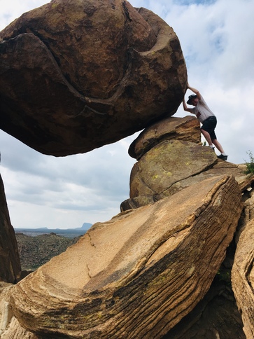
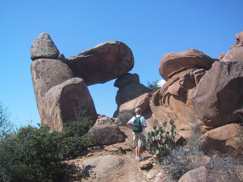
The goal of the hike, for many, is reaching Balanced Rock, which resides on a ridge at the end of the trail. This rock, like an Egyptian sovereign carried aloft by his Nubian slaves, casts his gaze over the trail you followed in your long pilgrimage to this august setting. (How's this for B-grade prose?)
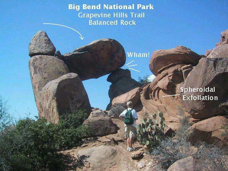
The image above indicates a possible (but unlikely) hypothesis for the formation of Balanced Rock. More likely it is an erosional remnant where the rock in the "doorway" of the feature weathered away. In fact, a great example of spheroidal exfoliation, which my brother is looking at, is found right before you reach the rock. Also check out the boulder emerging from spheroidal weathering just behind him.
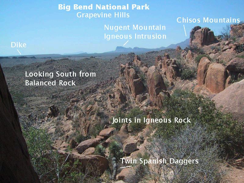
The view above is to the south from Balanced Rock. Note the twin Spanish daggers that serve as orientation between this picture and the one to follow. Directly below the "d" in the word "Balanced" in the picture, you might be able to make out a sort of miniature "Baby Balanced Rock" down the ridge on the left. Visible in the distance to the left is an igneous dike, a sheet-shaped body of igneous rock that solidified in a volcanic fissure. According to the USGS map, this dike consists of rhyolite. a volcanic rock of granitic composition. No date is given except that it had to be emplaced in either the Eocene or Oligocene.
In the far distance is Nugent Mountain, a large igneous intrusion exposed by erosion with Chisos Formation rocks of sandstone, tuff (consolidated volcanic ash), and rhyolite on its eastern side. No specific date for the Chisos rocks, which were laid down in the Eocene to Oligocene, but there is a date for the intrusion itself: 31.5 million years. Just to the right of Nugent Mountain you see the eastern edge of the main body of the Chisos Mountains. In the foreground the jointing pattern responsible for allowing such extraordinary terrain to be created is well-displayed.
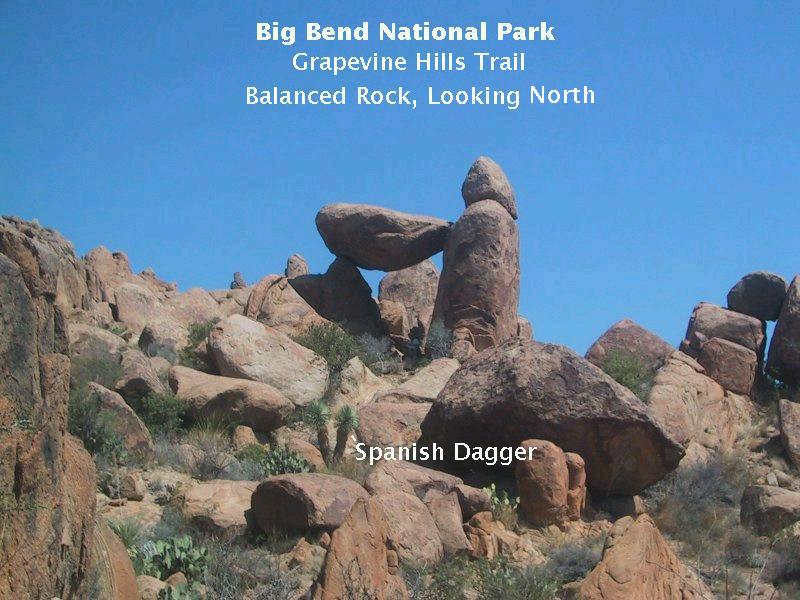
"Baby Balanced Rock" is only about six or so feet long but large enough to stand on and take the above picture of Balanced Rock from the south.
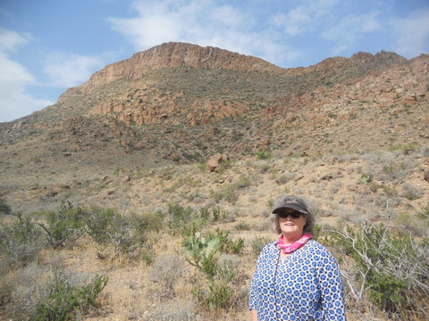
Update. I took this hike a second time on May 13, 2019, with my wife, Nora. The next picture is of her standing on the trail near its beginning. Now, both of us are getting up there in age, but she was a real trooper when it came to the challenging climb up to Balanced Rock at trail's end.The light-colored stratified-looking rock may have been derived from the Aguja Formation (see below). I didn't expect to see any limy rocks on this hike as we would always be on the syenite, so I didn't have my acid bottle to check it out. This is not the first time I've messed up by not being prepared. I doubt the stratified look is due to bedding planes. More likely it is due to fracturing in the fault zone.
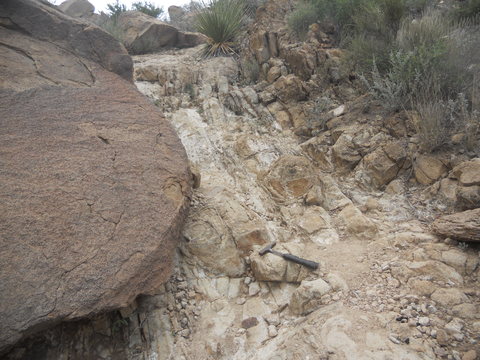
End of update. After a good morning's hike, you have returned to the beginning of the trail, and, as you come out of the draw, you observe the trend of the fault that led to its creation (below). (Randy and I clambered up the boulders for this view and rested unseen while watching late-arriving hikers make their way up the trail.)
In the distance you can see that the trend of the fault runs off into the surrounding alluvium. The geological map indicates a contact might be found between two types of rock across the fault, if you can find a location where the alluvium has been removed by erosion. On the up-faulted side you should find igneous rock that has been exposed by uplift and erosion; on the down-faulted side Cretaceous rock preserved where erosion has not yet eaten down all the way to the igneous rock.
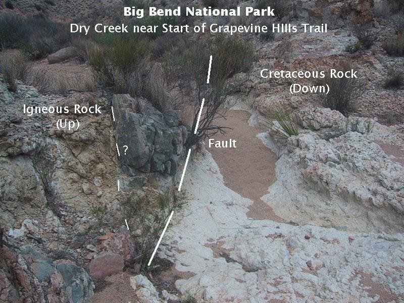
The trace of the fault is seen above in a small arroyo into which the rare flash-flood waters drain from the draw. On the left (west side) the uplifted igneous rock is seen, whereas on the right you have sedimentary rock with the igneous intrusive rock presumably at some depth below the surface. The map shows the sediment belongs to the Aguja Formation, described in the geologic literature as sandstone and clay and can be calcareous. The rock here appeared to be quite limy, but unfortunately, I didn't have my HCl acid bottle with me at this point to help determine the rock type. (Limy rock fizzes when you put a drop of dilute hydrochloric acid on it.)
At the time I was not sure whether the fault line was located as drawn on the figure by the thicker line or by the thinner one. After some thought at a later time, I suspect the major fault is marked by the thicker line, and the rock on the left of the fault is Aguja formation altered by the heat of the intrusion. Then the thinner line is another, minor fault – probably localized. I would have liked to have done some more investigation, but it was time to go, Randy was waiting and we had more on our agenda for that day.
FORWARD to the South Rim Trail, Basin
BACKWARD to the Marathon Uplift
ALL THE WAY BACK to the Contents