Hoodoo... Hoodoo You Think You're Foolin': Hoodoos in Tornillo Flat
(With apologies to Paul Simon.)
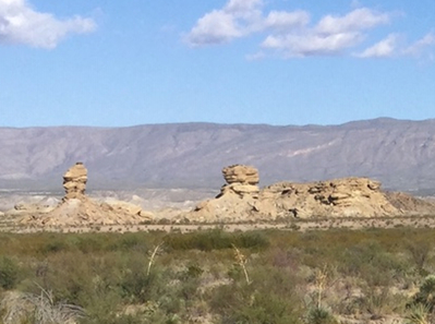
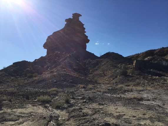
The best day I had during my largely pathetic trip to Big Bend in April of 2019 was the day I spent with the hoodoos. These are erosional remnants of, generally speaking, the Tertiary Canoe, Hannold Hill, and Black Peak Formations, although the Black Peak includes Cretaceous sediments. The Canoe and Hannold Hill Formations are Eocene (34 to 56 million years ago) whereas the Black Peak dates from the upper Cretaceous to the Paleocene, which ended about 56 million years ago, giving way to the beginning of the Eocene.
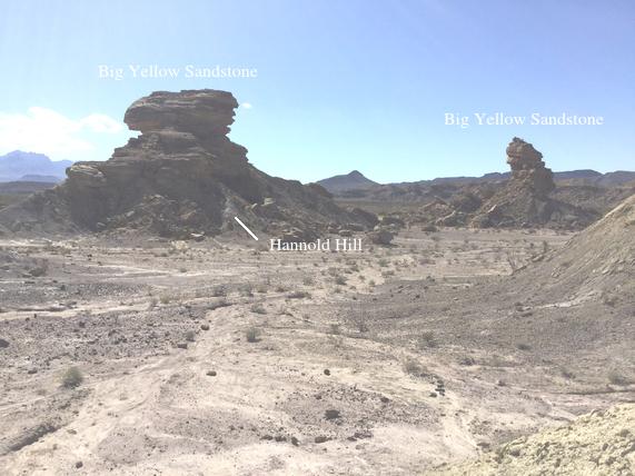
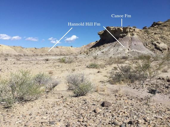
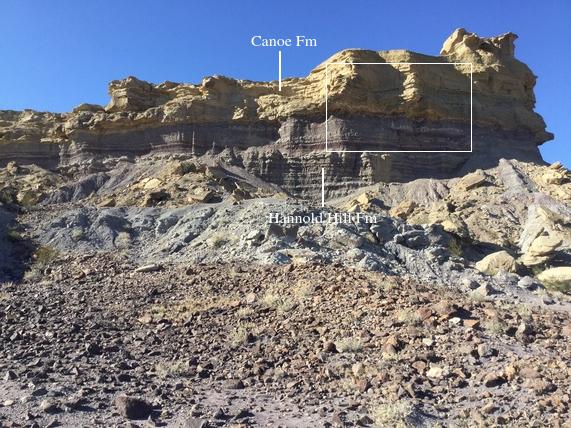
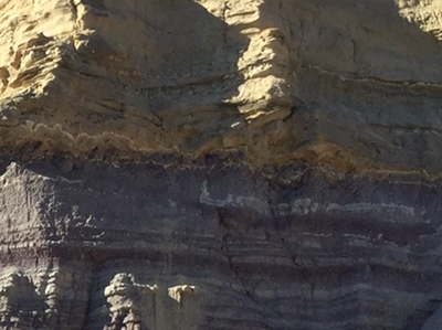
Below is not the first picture I took that day as it took me a while to hike from a designated parking area on the main park road to where these hoodoos were located. As I related in the River Road trip, I lost the function of my camera and had to use an old iPad to take photos. The shadows were bad, but I think the iPad was just not up to the task at hand anyway. Many of the photos I took had to be run through Gimp to adjust brightness and contrast. I identified the "cap rock", the resistant rock protecting the more easily eroded material below, as the Big Yellow Sandstone at the base of the Canoe Formation (Tc on the USGS geology map, Scientific Investigations Map 3142, 2011.) There is a time gap between the bottom of the Canoe and the top of the Hannold Hill called an "unconformity" in geo-speak. Note that not much of the Hannold Hill is showing due to a cloak of debris. In Tornillo Flat it seems to consist largely of a purplish mudstone.
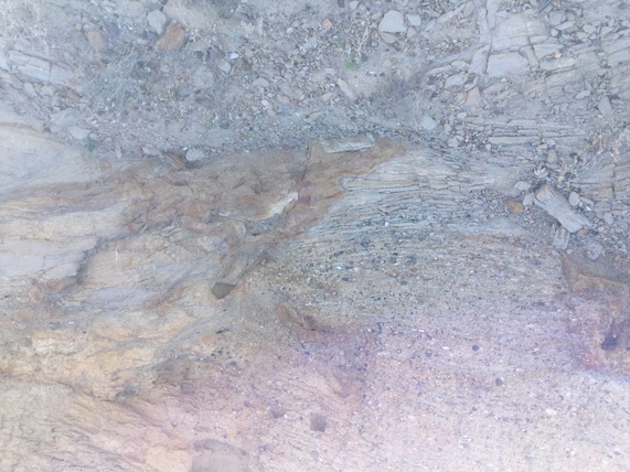
And here is an outcrop of the Big Yellow Sandstone. Note that some of the sandstone contains gravel and also note the concretions. Cross-bedding is also evident, especially in the close-up, the second picture below. This type of sediment is consistent with being deposited by streams, where the larger clasts (particles comprising the sediment) indicate the action of swifter water. Concretions form in the sediment after deposition as the rock ages, a process called diagenesis. The Canoe contains vertebrate fossils such as mammals and turtles.
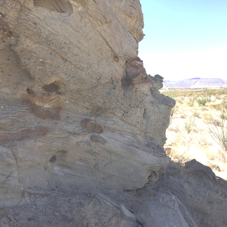
I found this interesting small cave full of scat at what appears to be the contact between the Big Yellow Sandstone of the Canoe, above, and possibly the Hannold Hill Formation below. Obviously some denizens of the flat use this for shelter and/or to sleep in.
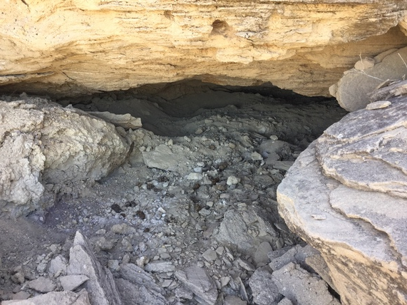
In the following image there might be a clue as to how the cave formed. Note the vein of calcite crystals between what I take as the Big Yellow Sandstone and the Hannold Hill. I found this vein pretty ubiquitous over the area I hiked, always at or possibly near the base of the Canoe. Calcite is a form of calcium carbonate (like Tums) and is the primary mineral found in limestone. It is also easily dissolved in water, especially if the water is acidic. Maybe the cave above was formed, at least in part, by the dissolution of the calcite vein at its location.
It seems strange that this layer is not mentioned in the pamphlet (USGS Circular 1327, 2011) accompanying the USGS map where the Canoe Formation is discussed. Possibly the layer has something to do with a soil that formed on top of the Hannold Hill – a "fossil" caliche layer? Or maybe with fluid containing calcium that diffused upward and collected beneath the sandstone? Certainly there is a lot of calcium carbonate at depth due to the significant Cretaceous limestone deposits.
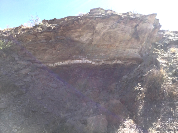
And, no, the following image is not a close-up of elephant dung. The iPad I was using as a camera is sometimes almost impossible to aim due to the reflection off the view screen, so this aim is low. I am pretty sure it is an outcrop of the dark mudstone of the Black Peak Formation. Mostly, the Black Peak seemed to be covered by debris and hidden over much of Tornillo Flat. Note the faint white streak in the outcrop, reminiscent of the more prominent one I examined along the River Road .
Later, after the above photo was taken, I found outcrops where the purplish Hannold Hill mudstone is clearly exposed with the Big Yellow Sandstone of the Canoe Formation serving, again, as a cap rock.
And here is a picture of a weirdly shaped boulder I decided to call the Clam. The western one of the two hoodoos shown in the first photo is in the background.

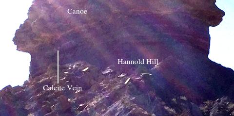
The following is a photo of the western hoodoo. Although I could see the calcite vein with the eye, the iPad photo is of poor-quality as the camera was pointing in the general direction of the light. However, I was able to "Gimp it" so that the calcite vein at the bottom of the Canoe shows up reasonably well in a digital close-up.
The digital close-up:
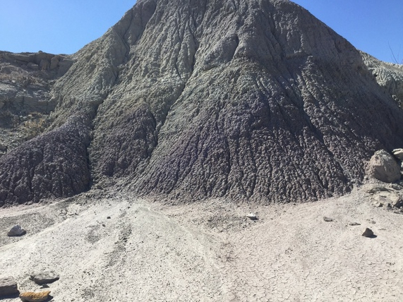
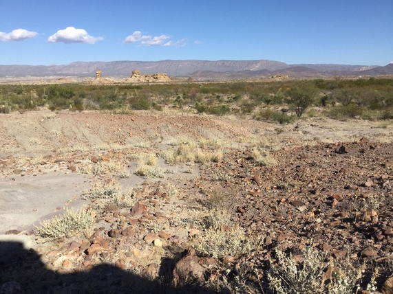
Below is a nice picture of the first two hoodoos I examined looking in a northeasterly direction. It also gives you an idea of the general appearance of Tornillo Flat.
The third hoodoo was toward the southwest edge of a hilly ridge. On my way to examining this hoodoo I walked to the southwest along the ridge, looking at the outcrops, starting at the northeast end of the ridge. The USGS geological map indicates a northwest-southeast trending fault, down to the northeast on the northeast side of the ridge. And indeed the fault was evident, although, once again, my iPad aim was not that great to the point that the down-faulted rocks are off the right edge of the photo.
Nevertheless in the field you can see how the rocks on the right (northeast) are lower than those on the left. You can also see a nice outcrop of the purplish Hannold HIll below the Canoe. The USGS map indicates the Black Peak Formation is here, but if it is it sure looks like it is covered with the erosional debris in the foreground. It was getting late and I just didn't have the time to look for signs of the Black Peak.
There also appeared to be calcite below the Big Yellow Sandstone here, but it was difficult to see due to the deepening shadows. In the following digital close-up of the boxed region in the previous image, you can see light-colored streaks. If these do correlate with the calcite veins seen elsewhere, it certainly appears that this layer is much less well-developed at this location.
Hoodoo number three from along the of ridge of hills, looking southwest:
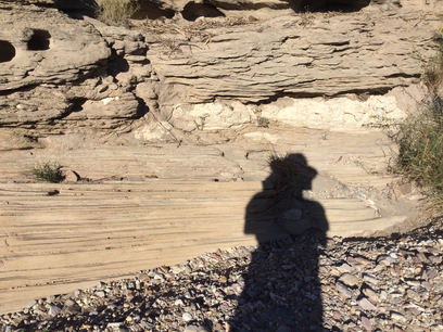
Here is Shadow Man looking at an outcrop near the hoodoo. This is evidently the Big Yellow Sandstone of the Canoe Formation. Note how the bedding changes from thin, continuous beds below to rough, discontinuous beds above, indicating a change in the depositional environment. Also note the large, elongated calcite concretion and cavities where likely there used to be calcite concretions until they were dissolved. The concretions, of course, formed long after the sediment was deposited.
I walked around to the Sun-lit side of the third hoodoo and took a picture with the iPad but it did not show up in the Photos folder. So I don't have a good picture of this hoodoo, but there was definitely a layer of calcite here also between the Canoe and the Hannold Hill. I'm pretty sure I took some other pictures on the way back, but there is no record of them in the iPad. I did get some sort of memory error – hard to read with the glaring Sun – but the iPad did work the next day. However, the next day was basically just a long hike in the desert looking for a certain geological feature in the Devil's Den area that I didn't find, and then it was back to Austin. But, there will be (I hope) another time.
BACKWARD to River Road West
FORWARD to TBD
ALL THE WAY BACK to the Contents