Update: In June of 2018 I extensively revised this field trip after consulting a report by Daniel P. Miggins et. al. in USGS Circular 1327, 2008 and a recently published USGS map in conjunction with satellite images. I had used some of the material in the USGS circular before, but with the map and satellite, I was able to put things together much better.
Alfred Hitchcock Presents: Blue Creek Canyon
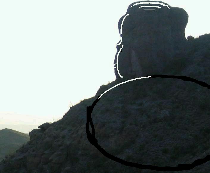
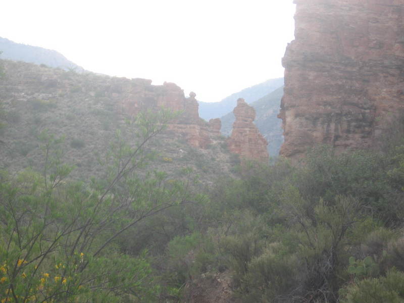
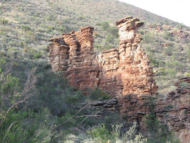
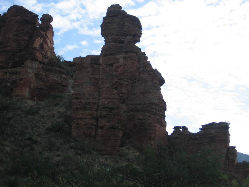
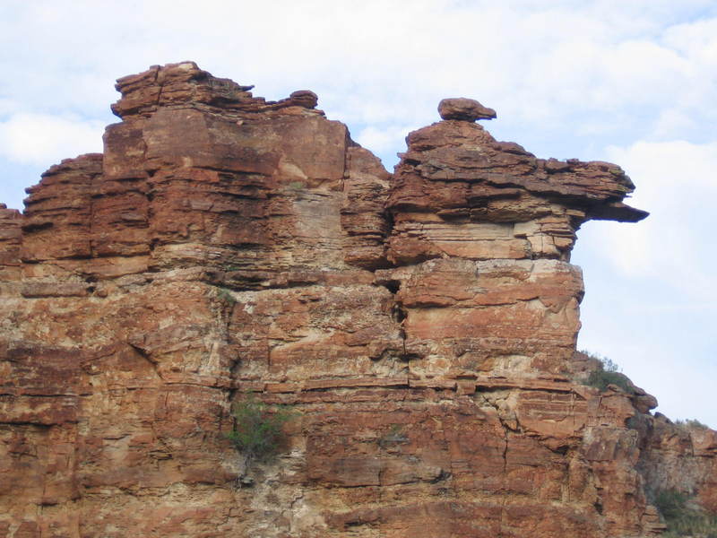
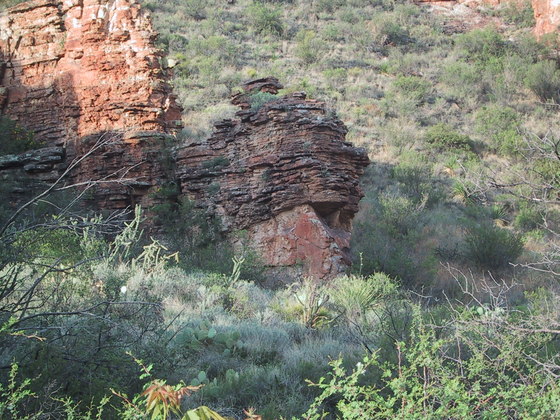
The lower reaches of Blue Creek Canyon could easily be the setting of a horror film. Rock formations that are fascinating by day turn into bizarre looking, monstrous figures at night. Even during the day, hiking up the trail beneath outcrop after outcrop of the most grotesque forms you can imagine, statuesque against the sky, you get the feeling of being dissected by the piercing gaze of gargoyles from the heights of a haunted Gothic cathedral. You might imagine the large boulder my brother and I dubbed "Hitchcock Rock", pictured above in the twilight, embodying the spirit of Sir Alfred, directing a terrifying drama unfolding in the ghostly terrain below.
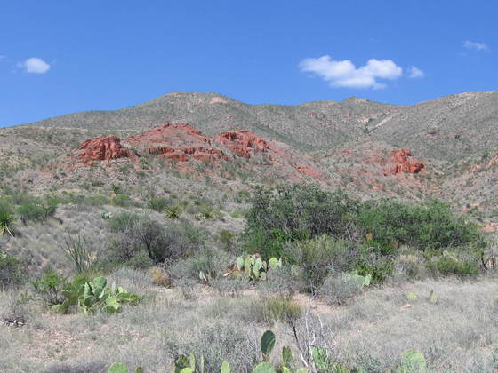
If you're into such nonsense, that is. My brother, Randy, and I were here in the summer of 2009 to investigate these enigmatic rocks we had come across on our exhausting August mountain loop trail trek. To tell the truth, I was so wiped out the first time we hiked by these rocks in the summer of 2008, I was ready for some gargoyle to end my misery. However, I did have the wits about me to wonder if these Blue Creek Canyon rocks were correlative to some red rocks, seen in the picture below, we had previously encountered on the western side of the Dodson Trail in the Sierra Quemada. I didn't know the answer to that when I originally wrote this, but, with the advent of the new USGS map, Scientific Investigations Map 3142, 2011, it now appears that if these rocks correlate to those in Blue Creek Canyon, they may be related to the Emory Peak Rhyolite member of the South Rim Formation. Rhyolite is a volcanic rock high in quartz and feldspar, that is, high in silica and low in iron. More about this rock later.
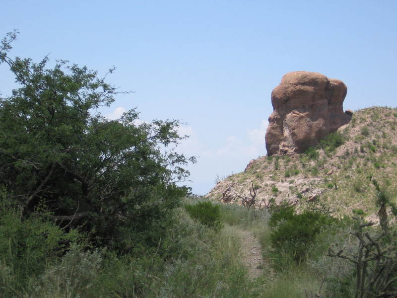
Blue Creek Canyon is on the southwest side of the high Chisos Mountains, accessed from Homer Wilson ranch just off Ross Maxwell Scenic Drive. The trail up the canyon takes you into the Chisos. But before I get into the geology of the Blue Creek Canyon rocks, here is a slide show – a sampling – of what you see at the beginning of your hike up Blue Creek Canyon. Be sure to have your imagination at full throttle when you examine these pictures, if you want the full experience.
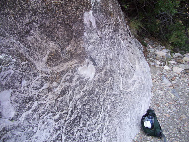
It's time to get down to the geology. First, old Alfred appears to be made up of the conglomerate that is also found on Carousel Mountain above the Homer Wilson ranch house, but I did not check that out. Below, you see a chunk had been broken off one of the outcrops about a mile above Homer Wilson Ranch. There has recently been a professional investigation of the volcanic rocks of Blue Creek Canyon, (USGS Circular 1327) and this may have been a result of sampling for that research. In any case, it allowed me to examine a fresh surface of this particular outcrop. The surface is shown below. (I don't break off parts of the outcrops myself in national or state parks and neither should anyone else without a permit.)
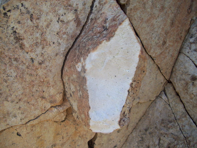
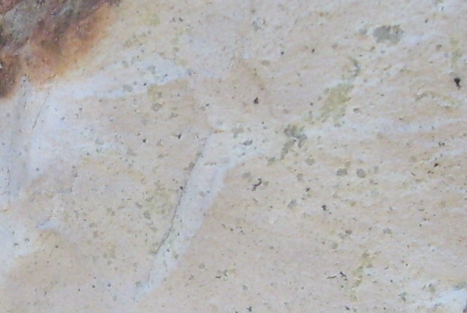
In the close-up below you can see that the appearance is strongly like that of a volcanic tuff. Tuff consists of small consolidated volcanic fragaments, often volcanic ash, and tuff this hard is known as a "welded tuff", as it was forged into a dense rock by the heat of the ash. Ash is typically thrown out of a volcano during a violent eruption (think Mt. Saint Helens or Mt. Pinatubo) but it can also form rock just below the surface. Most of the particles (tiny crystals of quartz and feldspar) are too small to be seen in the image, but you can see some larger quartz crystals (grayish, translucent particles) and a tiny scattering of dark minerals (most likely biotite). This rock compares well with the description of the Emory Peak Rhyolite given in the new USGS pamphlet on Big Bend geology. (Rhyolite is the volcanic equivalent to granite containing feldspar, quartz, and minor dark minerals.) The mineral content looks very much the same and the texture appears to be "tuffaceous" (like volcanic tuff) and holocrystalline (that is, all crystals, no glass) like the Emory Peak Rhyolite. The fresh rock is brilliantly white as the photo shows. The reddish coloring is a coating of iron oxide and/or iron hydroxide due to weathering.
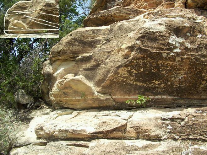
When I first wrote up this virtual field trip, I identified some of the rocks in these Blue Creek outcrops as sedimentary. They have layers which appear to be sedimentary beds, and I found the rock in the picture below, which appears to show cross-bedding. However, it could be this apparent sedimentary structure is due to the flow of rhyolitic ash that occurred during the pyroclastic (that is, explosive) volcanics that produced the rock rather than water flow. This observation causes a problem to be addressed below.
Due to the topographical setting of these "red rocks", I assumed they must belong to the Chisos Formation, a series of volcanic and sedimentary rocks ranging in age from 47 to 33 million years. However, I did recognize that they likely were deposited between the time of the 33 million-year-old Bee Mountain Basalt member of the Chisos Formation and a 30-million-year-old trachyandesite that was formerly thought to be the 33-million-year-old Tule Mountain Trachyandesite. This would put their age between 33 and 30 million years, stratigraphically at the top of or above the Chisos Formation. Recent work (Daniel P. Miggins et. al. in USGS Circular 1327, 2008) identifying them as at least related to the Emory Peak Rhyolite and not to the Chisos Formation, pins their age at 32 million years.
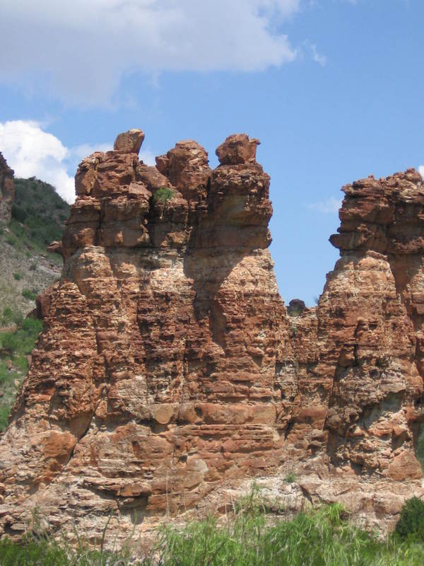
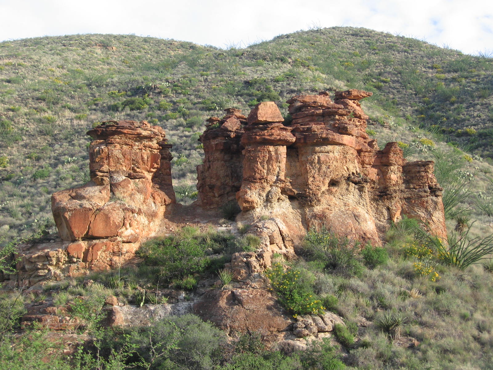
One of the mysteries of these rocks is, "Why do they come in wall-like outcrops, more or less equally spaced up Blue Creek Canyon and transverse to the canyon?" See the picture below, looking southwest down the canyon.
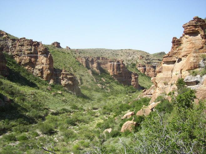
Satellite pictures show these red rock outcrops are associate with a system of NNW-SSE trending ridges on the south side of Blue Creek Canyon. (I am going to refer to the outcrops as "red rocks" for short, despite the fact they are actually white with a reddish coating.) The area where the ridges occur are shown to be the younger, divided rocks of the Chisos formation, labeled "Tcy" on the USGS map. These ridges do not appear well-expressed on the north side of Blue Creek except lower down the canyon just to the east of Carousel Mountain. Also, the red rocks do not outcrop significantly (or at all) farther up the canyon, but it certainly appears from satellite imagery that these ridges are associated with the trend of the red-rock outcrops.
If the red rocks do in fact exist in the older Tcy, they must be intrusive, which means they are probably volcanic dikes, sheet-like intrusions of magma. Their texture, described above, would indicate the ash of which they are composed solidified just below the surface. The apparent "bedding" can be explained by the fact that many dikes show fracturing perpendicular to their sides and generally oriented horizontally, presumably due to shrinking as the rock cooled. But then there is the puzzle of the apparent cross-bedding discussed previously. Also, some of the outcrops certainly give the appearance of having bedding planes. But, if the red rocks are contained within the Tcy, they obviously could not have been a continuous stratum. In retrospect, I think the apparent cross-bedding is just due to the ash flowing while it was still malleable.
The problem with considering these rocks to belong to the Emory Peak Rhyolite is that the Emory Peak Rhyolite is thought to have originated in the eruption of the Pine Canyon Caldera, which was in Pine Canyon on the other side of the high Chisos Mountains. It could be these rocks were emplaced as dikes at the same time and even from the same source. Supporting this view is the observation of Miggins et. al. that the tuff they studied in the Blue Creek Ranch area appeared to have been erupted locally, possibly from these dikes. It is puzzling to me that Miggins et. al failed to mention these bizarre outcrops.
There is other interesting geology along the trail up the canyon. In the following image you see exfoliation of a massive tuff bed due to weathering processes. Large-scale exfoliation, such as seen in the granites of the Sierra Nevada, has often been attributed to pressure release as the rocks are lifted upward by tectonic forces and erosion removes the overburden. This is obviously not the case here as these are volcanic rocks that were deposited at or near the surface of the Earth. Possibly chemical changes have caused the minerals at the surface of the rock to swell, creating stress that leads to the exfoliation observed. Alternatively, fire can also cause exfoliation, although the fire-produced exfoliation I've seen doesn't look similar to that on this outcrop.
Then there is the weird-looking outcrop seen below. What's up with this? You see a deposit with thin "beds" overlying a solid mass of rock. At first I thought the unbedded mass is a welded tuff deposit, and the thin-bedded deposits may have been laid down by a series of later volcanic actions. If these are volcanic dikes, however, this explanation won't fly. Of course, if the red rocks are igneous dikes, the "bedding" would really be jointing (fractures in rock across which no motion has occurred – in other words "cracks") due to thermal contraction. Possibly the solid mass resisted the jointing. Also, if you examine the fifth picture in the "slide show" above, you will see rock masses similar to the one here.
Although the maps referenced here only show faults running perpendicular to Blue Creek Canyon, the photo below seems to show a fault that runs parallel. It should be noted that this is a telephoto and there is a certain fore-shortening involved. Using satellite images and the newly published USGS map of Big Bend geology, I believe I have identified the dike in the picture on the USGS map. The map shows no fault here, but the presence of the dark bed above the white volcanic ash certainly implies the existence of a fault to me.
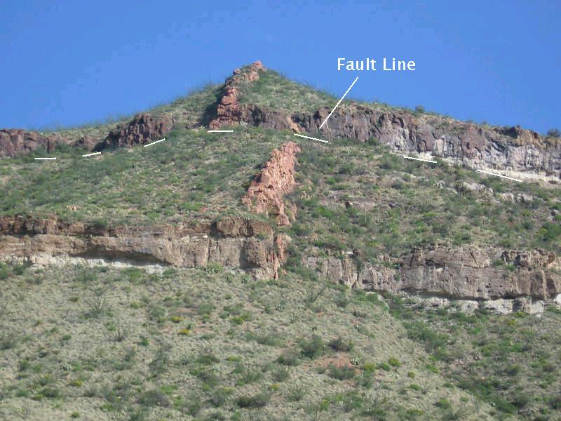
Assuming it is a fault, you might glance at this picture and immediately surmise the movement along the fault was left-right. This would make it a strike-slip fault; in particular, a left-lateral strike-slip fault, since the dike on the far side of the fault appears to be shifted to the left. (If you think about it, you'll see that it doesn't matter which side of the fault you are on; it is still a left-lateral fault.) However, what about volcanic bed with the ash (white) directly below it? It appears to have been shifted up on the far side of the fault. This would make it a dip-slip fault.
There are two possibilities here. The fault could be a combination of strike-slip and dip-slip, in which case the relative motion of the rock in the foreground along the fault plane would be down and to the right. On the other hand if the dike has a dip toward the left of the image, the fault could be purely dip slip with no horizontal offset at all. Erosion would make it appear that there was a horizontal offset. (The dike appears to be oriented vertically, however.) It could be a fault that was originally strike-slip or dip-slip and was later reactivated by new and different stresses. What is certain is that the fault, if that is what it is, has a significant dip-slip component and the trace of the fault on the surface is parallel to the canyon.
The dike on the USGS map I've correlated to the one in the photo shows it is offset but without a fault involved. The map does show that the offset occurs at about where the Bee Mountain Basalt member of the Chisos Formation outcrops. This could make the white material below the basalt the Mule Ear Spring Tuff member of the Chisos Formation. In that case you would have to identify a fault here. The map is in error in one aspect as it shows the dike being offset in a right-lateral sense, whereas both my photo and the satellite image show the dike is offset in a left-lateral sense. The Bee Mountain Basalt consists of several lava flows with ages ranging from 34 to 33 million years, and the Mule Ear Spring Tuff is dated between 33.6 to 33.7 million years before the present. Unlike rhyolite, basalt contains relatively more iron and relatively less silica. The Mule Ear Spring is located just below the youngest Bee Mountain flows and above the older ones. My opinion is this feature is indeed a fault and may be too small to appear on the map.
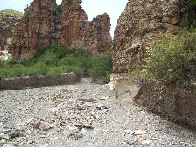
Arriving at Homer Wilson Ranch in the summer of 2009, preparing to hike up and camp at the "red rocks", we noticed significant changes since our last visit. Blue Creek had eroded steep sides into the alluvium of the creek bed. Obviously, a major flooding event had occurred since we were here in 2008. This event was very evident as we made our way up the canyon. The trail was washed out in many areas. In the following photo you can see the extent of the erosion of the flash flood at one location along Blue Creek. The bank on the far side, resulting from material eroded by the flood, is about seven feet tall (!). Also, notice the color difference on the rock outcrop on the right of the creek where about six or seven feet of creek bed was removed. What a flood it must have been to remove all that material! Erosional processes continue to reshape the Big Bend region, and here you can see that rare but large events can have a substantial impact.
BACKWARD to Mesa de Anguila III
FORWARD to Telephone Canyon I
ALL THE WAY BACK to the Contents