Playing with Blocks: Telephone Canyon I
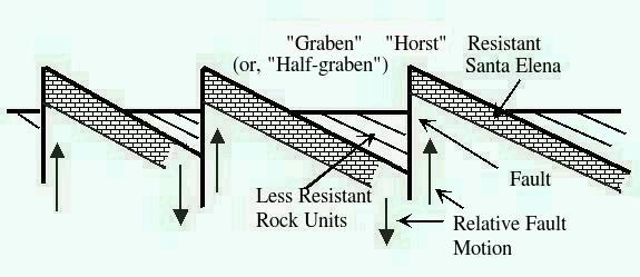
The eastern region of Big Bend National Park is a nice example of fault-block mountains and constitutes the eastern-most extent of the Basin and Range geologic province in the United States. This province extends from southwest Texas as far west as southeastern California and north through Nevada and Utah. It is a region of crustal extension caused by tensional tectonic forces (that is, forces originating in the solid Earth that tend to pull the crust apart) that began around 17 million years ago and is continuing today in much of the province, although extension in the Big Bend area seems to have ceased, or at least quieted, over the past two million years. Fault-block mountains are formed when, under the influence of tensional stress, a pattern of parallel faults is created, separating relatively downward faulted blocks from relatively upward faulted blocks. The higher blocks, called horsts, form parallel mountain ranges, while the downward faulted blocks, called grabens, are filled with erosional material from the higher blocks, often forming bolsons, which are flat desert valleys surrounded by hills and/or mountains often with no outlet for water (a situation termed "internal drainage").
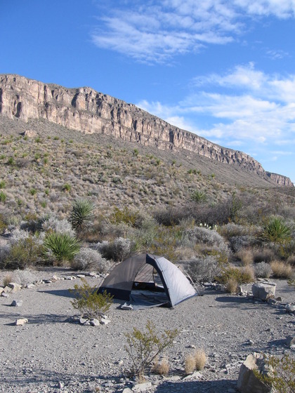
The hike into Telephone Canyon begins at the base of the western-most uplifted block in this area, which forms the NNW-SSE trending linear mountain, Alto Relex, 3922 feet in elevation at its highest point. Below is a view of a cliff on the western side of Alto Relex, consisting of the Santa Elena Limestone of lower Cretaceous age. The cliff is a fault scarp created by upward movement of Alto Relex with respect to the rocks on which our tent rests (the upper Cretaceous Boquillas Formation). The Santa Elena Limestone is the same unit of rock that forms the cliffs in Santa Elena Canyon. This limestone was laid down in a shallow tropical marine environment. At that time this area was near the equator. Since then, continental drift has moved Texas to its current position (which, as the weather in latest December and earliest January, 2009-2010, when we (my brother Randy and I) were there proves, is definitely not anywhere close to the equator).
The Telephone Canyon trail first takes you up over the northern edge of Alto Relex, through a gap, and then down into a graben on the east side of this mountain. Near the highest point in the gap is a small abandoned dam built long ago, before the area became a national park. The dam was constructed of cemented blocks of rock.
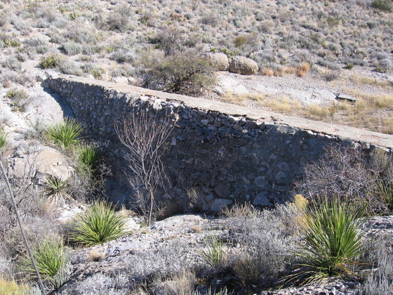
I was puzzled by the placement of the dam just below the top of the gap. As a result of this placement, the drainage area above the dam is pretty small, such that it seems there wouldn't be enough drainage to fill the reservoir except in the rainiest of times. Certainly, it was dry as a bone when we were there.
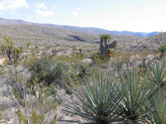
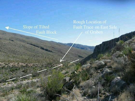
After passing the dam, you make your way down into the graben on the east side of Alto Relex. Below is what you see as you enter the graben.
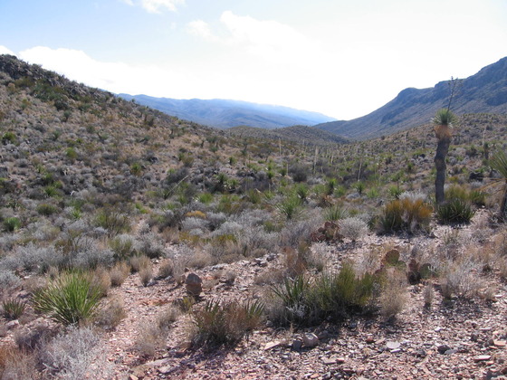
In the next picture you are in the graben at 3400 feet looking southwest, about 500 feet above the Old Ore Road where the Telephone Canyon vehicle campsites are located. The ridge to the immediate left is the relatively low southern edge of another uplifted block of rock. (The block rises to a mountain a bit over 4000 feet high to the north.) In the distance are the mountains associated with an uplifted block farther east. This is the block you must cross to enter Telephone Canyon.
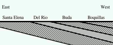
The rocks on the floor of the graben increase in age from west to east due to an approximate average dip of 10 degrees to the west (see below). (One of the geologist's rules of thumb is that rocks get older in the up-dip direction.) The youngest rocks belong to the upper Cretaceous Boquillas Formation (mostly limestone) on the west side of the graben. To the east of the Boquillas, progressively, are the Buda (limestone), the Del Rio (shale), and the Santa Elena on the east side of the graben. The graphic below shows the stratigraphic situation in the graben schematically, looking south as in the picture just above. No faulting is shown. In reality there are north-south trending faults on both the eastern and western edges of the graben.
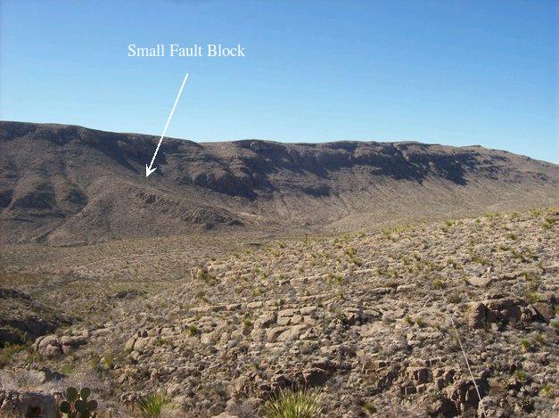
As you approach the eastern side of the graben and look back to the west, you observe what appears to be a small fault block on the east side of Alto Relex. According to the new USGS map (Scientific Investigations Map 3142), this block is not associated with faulting and is topped with the Sue Peaks Formation, although the Sue Peaks is generally not as resistant to erosion as the Santa Elena on Alto Relex in the background. Ross Maxwell (The Big Bend of the Rio Grande, 1968), on the other hand, mapped the rock here as the upper Cretaceous Boquillas Formation along with faults that may have bracketed the block. However, if the rock beneath resistant bed at the top of this feature consists of the Sue Peaks, the resistant bed could not be Boquillas, since the Santa Elena, not the Boquillas, rests on the Sue Peaks.
So possibly the thick bed on the top of this cuesta-appearing feature is the massive limestone bed in the middle of the Sue Peaks, but it may also be part of the Santa Elena. I'm going to be a bit of a contrarian and propose that this is indeed a block – faulted off the side of Alto Relex and topped by either a bed of the Santa Elena or the middle bed of the Sue Peaks – and that it really is dipping the way it appears. There should be faults bordering the block, as Maxwell claimed, if this is the case. This view appears consistent with how things look on Google Earth. (I don't have to face peer review, so there.)
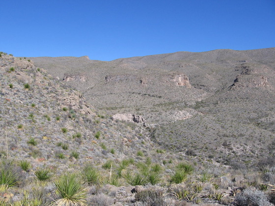
The beds in the foreground are of the upper Cretaceous Buda Formation and dip to the west at about 10°, which seems to be fairly typical for the beds in this fault-block region. (I previously inadvertently misidentified these beds as Santa Elena. I'm not sure how that happened as they certainly look like Buda and not like Santa Elena, and that is how they have been mapped.)
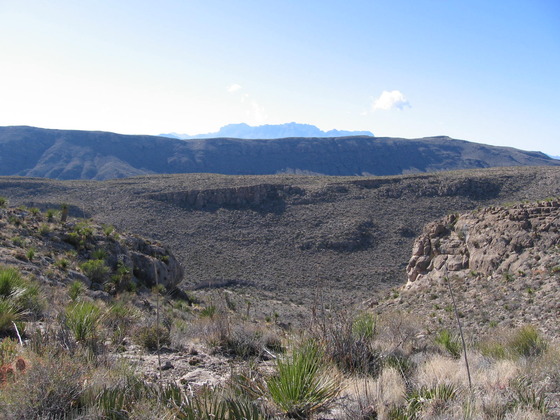
On the eastern side of the graben you encounter the upward slope of the next block. The two photographs below show how the slope rises to the east, parallel to the dip of the Santa Elena Limestone (again, about 10° to 15° to the west). The Santa Elena is resistant to erosion in this arid region, forming slopes such as shown below on the down-faulted side of the uplifted block, and scarps on the up-faulted sides (as that seen on the west side of Alto Relex pictured earlier). The first photo is to the northeast while the second is to the southeast. In actuality, the blocks that form the mountains here are not so much uplifted per se as they are tilted by the faulting pattern. The photos show the down-faulted side of the block. The topographical relief is as much due to the erosional resistance of the Santa Elena as it is to the faulting itself.
The next graphic indicates schematically how the topography in this area was formed. The faulting and tilting of the blocks as a result of crustal extension, in conjunction with the resistant Santa Elena Limestone, created much of the present topography. The "horst"- and "graben"-appearing topography is, therefore, often due to cuesta-like landforms. The lower regions of the tilted blocks are often called "half-grabens" It should be noted that the fault planes are not perfectly vertical as shown in this schematic, but tilted to account for the crustal extension .
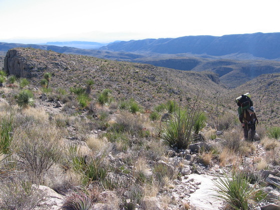
Now you are climbing up the next fault block to a 4440-foot high point before beginning your descent into Telephone Canyon. Looking back to the west, you can see a series of fault-block mountains. There is the one you are on, and then, to the west, is the one you crossed on its south side, and, finally, there is Alto Relex, a true horst (faulted upwards on both east and west, unlike the cuesta-like blocks), and the first in the series of blocks. In the distance are the high Chisos Mountains, which owe their existence, not to fault-block processes, but to differential erosion.
In the next picture you are looking southwest. You can see the southern end of Alto Relex and the fault block between you and that mountain. In the far distance is Chilicotal Mountain. This climb with heavy backpack is not for everyone. (And not for us again!)
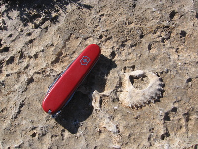
The rocks beneath your feet as you make this climb are those of the Santa Elena Limestone. This unit is not known for its fossils1. So, we were very surprised to come across a fossiliferous area along the trail. In the following photo you see the shell of an oyster preserved in the limestone. I don't know for sure what species this is, but some "googling" indicates it may be of the genus Lopha– a so-called "cockscomb" oyster. Naturally, this fossil is still there as we do not steal what belongs to all Americans So, future backpackers, look for these fossils and enjoy! And leave them in place.
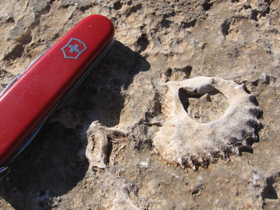
1 This statement is from personal observation. For example, I don't recall a single fossil when we crossed the Santa Elena on Mesa de Anguila. However, I understand that rudists are abundant in places and gastropods have been found. (At a later date I found gastropod fossils in the Santa Elena along the Marufo Vega trail.)
BACKWARD to Blue Creek Canyon
FORWARD to Telephone Canyon II
ALL THE WAY BACK to the Contents