Below is a typical view as you make your way down the creek that forms Boot Canyon. This is a classic V-shaped, water-carved valley, as opposed to a U-shaped glacially formed valley. (Of course, you wouldn't expect glacier activity in the recent geological history of Texas. The last time any part of what is now Texas saw glaciation was possibly during the Neoproterozoic glaciation of 775 to 625 million years ago. Even so, the surviving evidence, if any, would be deeply buried under later sedimentation.)
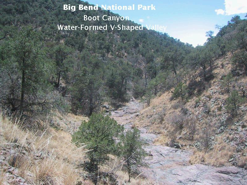
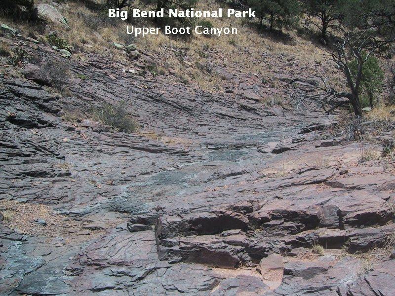
The erosion proceeds by several basic methods. In the stream bed itself (when it rains) flood waters carry abrasive material – mostly silt and sand – that eats into the underlying volcanic rock like sandpaper. This produces the polished bedrock effect seen in the next image. The sides of the valley are exposed to weathering and creep. Creep is the process where gravity gradually pulls soil and rock loosened by weathering down toward the stream bed. (As a geologist in the field, this is the only kind of creep you hope you'll come across.) Once it is within reach of the flood waters, it is entrained in the flow. Finally, the running water tries to meander from one side of the valley to the other, eating into the creek banks. By these processes the canyon is deepened and widened.
The image below is a picture of the famous "Cowboy Boot" from which Boot Canyon obviously gets its name. The "boot" was formed by erosion along fractures (called joints in geological terminology) in what was until recently called the Wasp Spring Flow Breccia. The rock has been reassigned to the Boot Rock Member of the South Rim Formation, volcanic rock 32 million years old. Enjoy it while you can, because, like the recently deceased "Old Man of the Mountain" in New Hampshire, it will inevitably succumb to the erosion that gave it form. My brother, very sacrilegiously, would like to rename this feature "The Can-Can Dancer". We may have to excommunicate him from the fellowship of Texans. (Isn't it ironic that New Hampshire, the "Granite State", chose the "Old Man of the Mountain" for the logo on its state quarter. Right after they did, it collapsed. Murphy lives!)
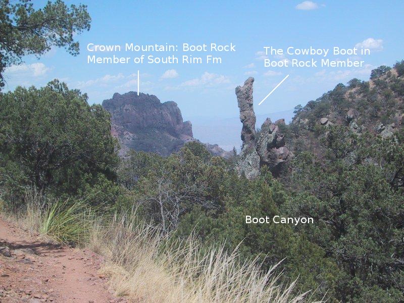
I was a bit dismayed to see some rock climbers had recently scaled the Boot and left cables and whatnot on it. If you do rock climbing in Big Bend you need a permit, AND you need to pack out all your stuff. Note Crown Mountain in the background. Until recently the rugged top of the mountain was said to consist the Burro Mesa Rhyolite resting on the Wasp Spring Flow Breccia. Recent work by a number of geologists, along with new radiometric dates, has resulted in a revised view of the rocks in both the Chisos and on Burro Mesa. The rock topping Crown Mountain is now the Boot Rock member of the South Rim Formation, consisting of a variety of volcanic types of rhyolitic and trachyitic composition. These are rocks termed "felsic"; that is, containing abundant silica in the form of feldspars with low concentrations of iron and magnesium. Trachyte differs from rhyolite in having an enhanced abundance of alkali metals with little or no quartz.
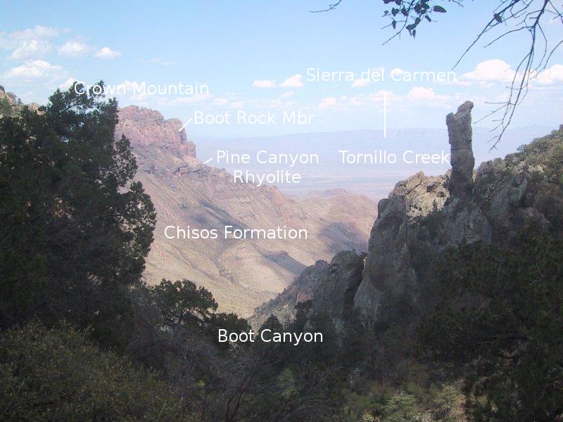
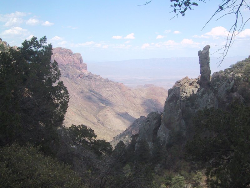
This last view is from Boot Canyon, across Tornillo Creek, and toward the Sierra del Carmen. The Brown Rhyolite is now designated as the Pine Canyon Rhyolite Member of the South Rim Formation. It was formed from one or more violent eruptions of the Pine Canyon Caldera, including searing pyroclastic flows that resulted in a type of volcanic rock called ignimbrite.
The 32-million-year-old Pine Canyon Rhyolite lies unconformably on top of the younger undivided (not studied well enough to identify the various units) members of the Chisos Formation. Some rocks from this member have been dated, and range from 33 to 45 million years in age. "Unconformably" means there was an extended period of time when nothing was deposited and probably a lot was eroded away. Since such unconformities indicate missing rock units, they are gaps in the geological record. All they "record" is that there was a certain length of time (probably on the order of a million years in this case) when non-deposition and erosion reigned.
FORWARD to Boquillas Canyon
BACKWARD to the South Rim Trail
ALL THE WAY BACK to the Contents