My family and I used to drive up to a family camp in the Sierra Nevada Mountains just west of Yosemite National Park every year. (This was a tradition I inherited from my wife's family, who are from California.) Along route 120 there is a scenic turnout with a broad view. The turnout claims this is the "Rim of the World". Well, as much as I love the area where we camped each year... sorry, but if there is a rim of the world in the continental U.S., and it's not the Rim of the Grand Canyon, it would have to be the South Rim in Big Bend National Park.
Update. The camp, Berkeley Tuolomne Family Camp, was destroyed in 2013 by the Rim Fire.
When you first arrive at the South Rim after a hike of several hours from the Basin (taking the western route), you come across a view like that below, toward the west. Unfortunately, we were there on a day when the visibility was especially poor. The degradation of the air in the park is a tragedy. If you look at photographs taken twenty years ago and compare the visibility then with what it usually is these days, it's heartbreaking. I don't know if desert power plants or desert development to the west or something else is to blame, but what should be a clear view deep into Mexico is at times a challenge to make out the Rio Grande.
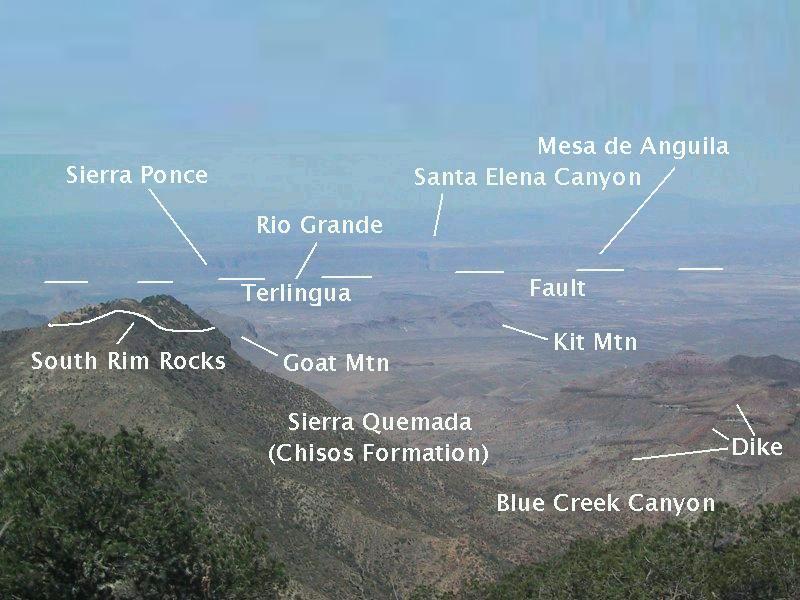
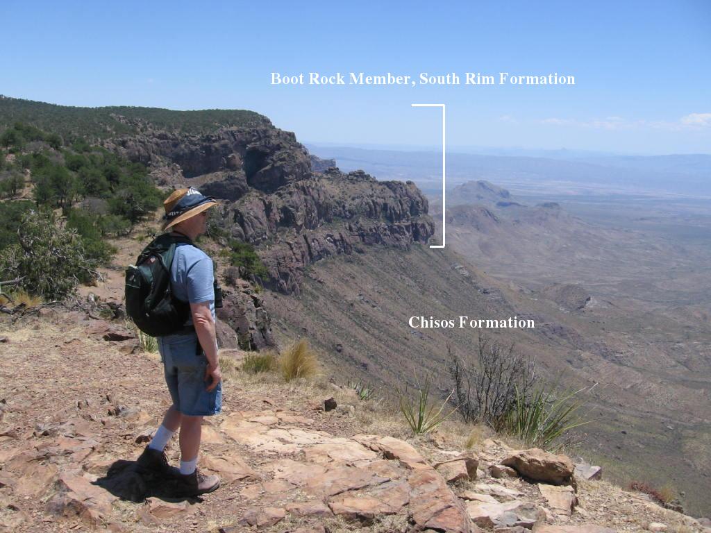
It is still an awesome view, however. You are standing at about 7000 feet in elevation - one mile above the Rio Grande; in the distance is Mesa de Anguila (Sierra Ponce on the Mexican side), composed of Cretaceous limestone. If you look closely you will see what looks like, from your distance of over 20 miles, a tiny slot in the limestone. This is the entrance to Santa Elena Canyon. Hard to believe from this distance that the walls of the canyon are 1500 feet high. To the right of the canyon entrance (north) and this side of the Rio Grande is Texas; to the left and beyond the Rio Grande is Mexico.
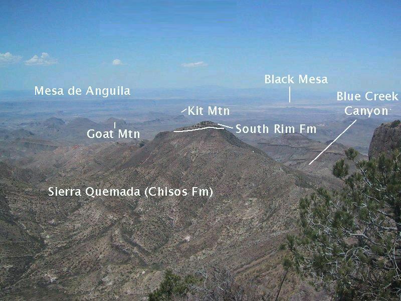
Santa Elena Canyon was carved by the Rio Grande as it ate down through softer rock into the harder limestones uplifted along the Terlingua fault, whose trace is marked by the dashed line. Ironically, the topographic high that is the Chisos Mountains is actually a down-faulted block called a graben. The reason the Chisos stand high is due to the resistant volcanic rocks of the South Rim Formation, which form a "caprock" protecting less resistant rocks below. The rock you stand on as you take in this view is the Boot Rock member of the South Rim Formation. In addition to forming the "cap" of the high Chisos, South Rim rocks are present as erosional remnants in the Sierra Quemada ("burned mountains") and, until recently, were thought to exist as remnants on Goat and Kit Mountains (in the distance). However, now it is thought the volcanic rocks on these mountains have a different origin, and the new USGS geological map (Scientific Investigations Map 3142) assigns these rocks to the Burro Mesa Formation, following previous field work.
The Sierra Quemada largely consist of the mostly volcanic Chisos Formation, but there are intrusions as noted in the second photo below. Because an area of rocks within the Sierra Quemada shows a circular pattern, it was once thought the Sierra Quemada was the result of a caldera eruption (a caldera is a circular collapsed volcanic feature), but more recent work indicates the circular feature is likely due to an igneous intrusion.
The South Rim rocks capping parts of the Sierra Quemada (with an example appearing the the photo above and that below) are described as volcanic outflow deposits that have not been studied. It is thought they may correlate to the Boot Rock member and/or the younger Emory Peak member of the South Rim Formation. Visible in the above photo is a volcanic dike that stretches from Blue Creek Canyon across the mountains on the extreme right. The dike cuts across dark layers which appear to be basalt (iron-rich volcanic rock).
Dikes are remnants of sheet-like intrusions of magma that result in fissure volcanic eruptions if they reach the surface. I had thought the flows crossed by the dike might belong to the 34-30 million-year-old Bee Mountain Basalt of the Chisos Formation, but the geologic map mentioned above assigns them to undifferentiated (that is, unclassified in detail and not named) mafic lava flows of the Burro Mesa Formation. A mafic magma is one that is rich in iron, magnesium, or (usually) both. A sample taken from a flow at the far end of the one in the picture gave an age of 38.9 million years, so it is definitely not the Bee Mountain Basalt.
.
The above view is a bit farther along the trail. The drainage on the left of the center peak is Fresno Creek. The telescopic view below is close to where the above picture was taken but is looking just west of south. In this picture you can see an intrusion in the Sierra Quemada. This rock does not belong to the Chisos Formation but is younger by the geological "principle of cross-cutting relations", since it pierces this formation.
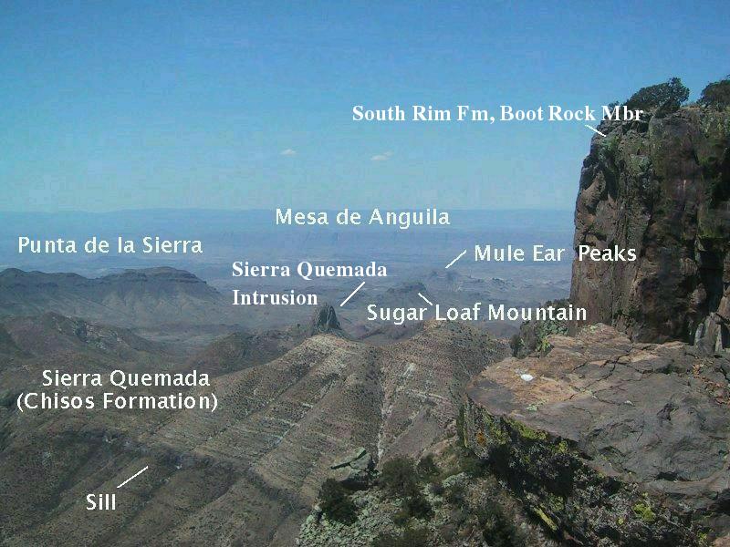
Landmarks in this photo include the famous Mule Ear Peaks and Punta de la Sierra. The Mule Ear Peaks are the erosional remnant of dikes consisting, according to the new USGS map, of a member of the Burro Mesa Formation called the Wasp Spring. Its name used to be the Wasp Spring Flow Breccia and was thought to be found up in the high Chisos as well as to the west of these mountains. Now the Wasp Spring Flow Breccia in the Chisos is considered to be part of the Boot Rock member of the South Rim Formation, and that at Mule Ears, Burro Mesa, and other places west of the high Chisos is regarded as a member of the Burro Mesa Formation. In other words, the Boot Rock and the Wasp Spring are recognized as having separate origins. The Wasp Spring is the result of a violent eruption or eruptions of magma high in silica and volatiles (mostly water vapor dissolved in the magma), resulting in flows of hot ash and debris. The Punta de la Sierra will be discussed below.
A sheet-like body of solidified magma called a sill is seen intruding the Chisos Formation. A sill is formed when magma seeps along a weakness in the preexisting structure - in this case between two beds of the Chisos Formation. This sill is one of the many basaltic/mafic sills found in the park, dating to the Oligocene and Eocene. Basalt and other mafic magmas are typically low viscosity ("runny") and so make great candidates for forming sills. This particular sill has not been dated, but two outcrops of similar rocks a couple of miles or so to the southeast were dated as 28.6 and 30.7 million years old.
Note the light bands outcropping on the side of mountain above the sill. These are beds of consolidated ash called tuff and are part of the large amount of undifferentiated younger Chisos Formation (labeled Tcy on the USGS map) yet to be studied carefully and classified. The "cap rock" of the South Rim appears in the foreground on the right, formed from lava flows and other types of volcanic rock rich in silicon and oxygen (silica) of rhyolitic and trachytic composition. Formerly, it was called the Lost Mine Rhyolite, but is now part of the Boot Rock Member of the South Rim Formation. The South Rim Formation appears to have been erupted from a small caldera in the northeast area of the present high Chisos Mountains, the Pine Canyon Caldera, around 32 million years ago. The volcanic rocks called trachyte are unusually high in potassium and other alkali metals compared to rhyolite, which is the volcanic form of granite.
I should point something out that may escape those not used to thinking in geological terms. The current relief does not mean the South Rim Formation was erupted on top of a mountain, as it might appear at first. These volcanic rocks covered a much larger area than presently and flowed over the ground as it then existed (on top of the Chisos Formation). They have since been lifted up by geological forces (although, as mentioned above, relatively down with respect to the larger environment) and largely eroded away, with the remnants forming the "cap rock" of the high Chisos Mountains.
The South Rim Trail takes you on an arc with views of the Big Bend region gradually more toward the east via the south. The view below is looking almost due south into Mexico.
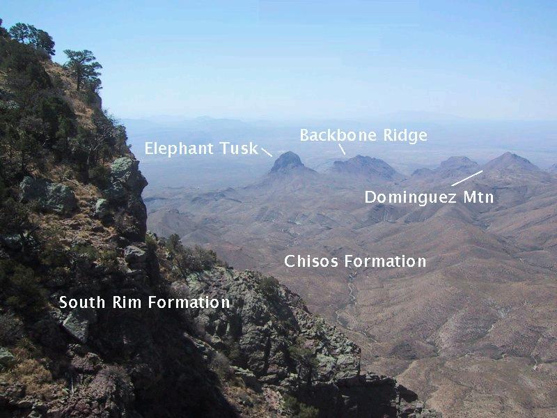
In this photograph you see the Boot Rock member of the South Rim Formation and several mountains five to six miles away. Two of these mountains are igneous intrusions emplaced circa 30 million years ago that have been exposed by – guess what! – erosion. They have pushed up into the Chisos Formation and are therefore younger. Elephant Tusk is a particularly prominent landmark, consisting of an undated (as far as I know, but considered to be around 30 million years old) rhyolitic intrusion. Backbone Ridge appears to be part of the same intrusion. They aren't connected at the surface but might be in the subsurface. The creek bed trending toward Elephant Tusk is Fresno Creek, which often contains water during the summer "monsoon" season (and did during our trip on the Dodson Trail). A telescopic view of these igneous bodies appears below.
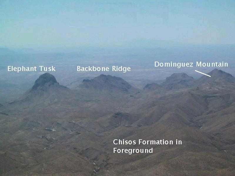
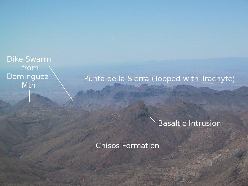
Dominguez Mountain is interesting. It is the remnants of an ancient volcano with a swarm of dikes spreading out radially from the center, especially to the southwest, where the dikes riddle Punta de la Sierra in what is called a dike swarm. In some areas the emplacement of these dikes was so dense – to the point of later dikes intruding earlier ones – that the original rock was replaced. The mountain itself consists of basaltic and andesitic lava flows that dip away from the center of the volcano. Andesite is a volcanic rock intermediate in silica content between high-silica rhyolite and low-silica basalt. The dikes are of a similar rock variety. In addition to the volcanic rocks, there are intrusive rocks around the mountain ranging in composition from high to low silica. The mountain has not been studied in detail, meaning much more waits to be learned. In particular, there don't seem to be any dates for its rocks. The mountain is visited in another field trip
To the west and south of the igneous intrusions is the strangely ragged Punta de la Sierra. The ragged appearance is not due to the presence of the South Rim Formation as you might first suppose. Whatever rocks were originally above have been removed by erosion exposing a 30 million-year-old volcanic rock called trachyandesite. (Ages of the rock were not taken at Punta de la Sierra, but samples from Blue Creek Canyon, Goat Mountain, and Tuff Canyon that are considered correlated to these rocks were all dated close to 30 million years.) These rocks were previously mapped as the 33 million-year-old Tule Mountain Trachyandesite of the Chisos Group (as it was then known and is now called the Chisos Formation) but are now no longer considered part of that formation. I realize "trachyandesite" is quite a mouthful. The prefix "trachy" to "andesite" has to do with the greater than average abundance of alkali metals in the rock. Note in the photo another one of the ubiquitous Big Bend igneous intrusions in the Sierra Quemada between the camera and Punta de la Sierra and an outcrop exposing the mostly debris-covered Chisos Formation.
To the east and south of the igneous intrusions, you see below (if I can reasonably use the word "see" here, due to the bad visibility) the entrance to Mariscal Canyon and the Mariscal Mountain anticline.
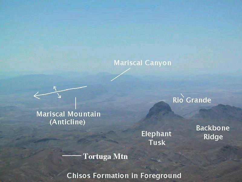
Mariscal Canyon (along with Boquillas Canyon farther east) was formed the same time as Santa Elena Canyon. All three canyons are due to the Rio Grande cutting down into uplifted Cretaceous limestones, and all three are spectacular for their shear cliffs, although Santa Elena is the best of the three in this regard. Also "visible" in the image is Mariscal Mountain, formed by the up-warping of rock into a fold called an anticline. The geologic symbol for anticline marks its location, and the pair of arrows indicate the rock beds dip away from the center of the fold. The Mariscal Mountain anticline is one of a series of N-S trending anticlines formed in SW Texas during a mountain building period, the Laramide orogeny, that deformed the Earth's crust throughout western North America during the Late Cretaceous and Early Tertiary.
During that time the North American tectonic plate was in collision along its western edge with the Farallon Plate. Most of that plate was subducted beneath North America. All that's left of it, apparently, are the Juan de Fuca and Cocos plates. Note the arrow on the line marking the axis ("center") of the fold. This indicates the anticline disappears under the surface in the direction the arrow points, making it what is called a plunging fold.
The rock exposure at the South Rim is a layer cake of volcanic rocks, and it's time to have a slice. The original photo showed that the three layers of volcanic rock here were each named. From top to bottom they were the Lost Mine Rhyolite, the Wasp Spring Flow Breccia, and the Brown Rhyolite, although I was never really comfortable with these identifications. Now, all these layers belong to the Boot Rock member of the South Rim Formation. Gone are the Lost Mine Rhyolite and the Wasp Spring Flow Breccia, and the Brown Rhyolite here has been folded into the Boot Rock member.
In other areas what was the Brown Rhyolite is now the Pine Canyon Rhyolite member of the South Rim Formation. Work that has been done since these rock layers were originally named has shown that they have essentially the same composition and are close in age. Hence there is no reason to consider them separate formations. The South Rim Rocks are now thought to have all originated 32 million years ago from the Pine Canyon caldera mentioned earlier. The Pine Canyon Rhyolite was erupted at the formation of the caldera and consists of rock formed by glowing ash flows (called ignimbrite) and volcanic glass (obsidian). The younger Boot Rock member includes rhyolite, ignimbrite, and a variety of other volcanic rocks erupted from volcanic vents after the caldera was formed.
Rocks to the west of the high Chisos that were originally assigned to the South Rim Formation constitute a newly named formation, the Burro Mesa Formation, whose rocks did not emanate from the Pine Canyon Caldera but from volcanic vents to the west of the high Chisos Mountains. Additionally, the Chisos "Group" has become the Chisos Formation. The formation is the basic mappable unit of geologists. A group is a collection of related formations. Often, a formation will consist of a series of distinctive units which are designated as members. So you have this hierarchy: Groups contain formations and formations contain members. Members themselves may be divided up into smaller beds.
Below are four views toward the southeast and east from the South Rim.
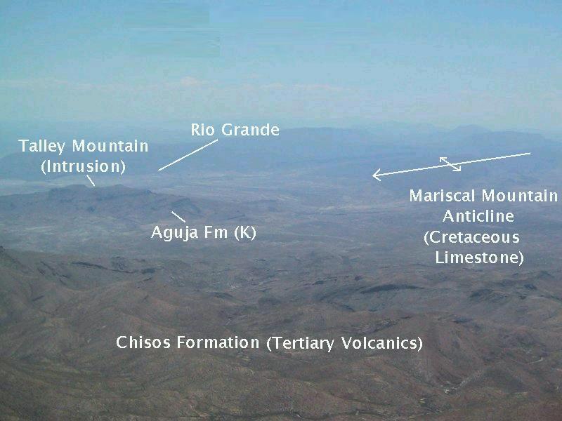
In the first view (above) you again see Mariscal Mountain. A new feature is yet another igneous intrusion, one high in silica like the ones mentioned previously in the Sierra Quemada, at Elephant Tusk, and at Backbone ridge. The late Cretaceous Aguja Formation, which records a transition to continental from marine deposition and contains fossil dinosaur bones near Talley mountain, is exposed on the mountain's flanks. And, of course, the mostly volcanic Chisos Formation rocks constitute the foreground.
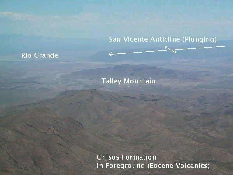
This second view exhibits the San Vicente Mountains in Mexico, which were formed by a plunging anticlinal fold during the same crustal compression that created the Mariscal Mountain anticline. In the distance you can just make out the Rio Grande; the ground between the Chisos rocks and the Rio Grande to the left of Talley Mountain is mostly alluvium, sediment deposited by running water - in this case by Tornillo Creek, which, when it rains, flows from the northern areas of the national park into the Rio Grande.
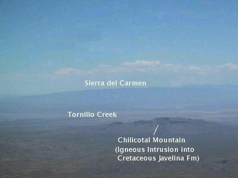
Thirdly, you look in the direction of Chilicotal Mountain, which is yet another igneous intrusion of the same type as that at Talley Mountain. Originally, I thought there was a fault crossing the mountain – I can't recall now where that idea came from (hopefully not from a drunken stupor) – but the USGS map shows no fault. The apparent offset in the photo is not identified as a fault on this map and is not really offset. The rocks of the "offset" are actually the same unit at the same stratigraphic level. The appearance of an offset is due to perspective. (I explain this to correct a previous version of this particular virtual field trip.)
The magma that forms Chilicotal Mountain intruded the Cretaceous Javelina Formation, a unit of mostly clay and sand that, like the Aguja, sometimes contains dinosaur fossils. A notable thing about both Talley and Chilicotal Mountains are the massive landslide deposits on their flanks due to erosion in the Tornillo Creek drainage system weakening the mountain slopes. In the distance the Sierra del Carmen in Mexico loom into view. These mountains consist of layers of Cretaceous limestone.
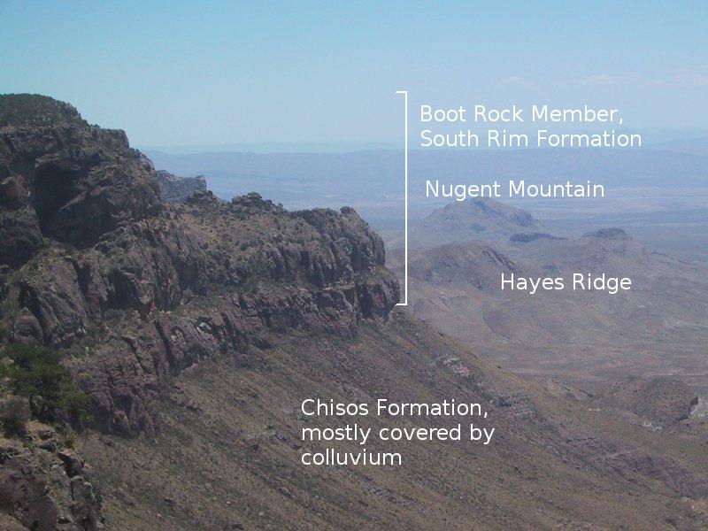
This final view from the South Rim is almost due east. You see Nugent Mountain and Hayes Ridge, both formed by intrusive igneous rock. Hayes Ridge appears to be part of a system of volcanic fissures that surrounded the Pine Canyon Caldera, and indeed the new USGS map shows the igneous backbone of the ridge to be the Ring Dike member of the South Rim Formation. A radiometric date of the dike gives an age of 32.6 million years. The South Rim layer cake is again in the picture. Below the layers is the colluvial sediment and talus draped over the Chisos Formation. Colluvium is debris at the base of hillsides deposited primarily by processes not involving water transport.
The last image of this section is one I got off the Internet from a no-longer present URL, "www.iloveparks.com/peaceparks", of the US and Mexico International Park Association, which was dedicated to the creation of an international park involving land on both sides of the border. This is a worthy cause, but this association no longer appears to be active. Perhaps another organization has taken up the baton. After a ridiculous border closure at Boquillas Crossing, it is now possible to cross over to the village of Boquillas, Mexico, shop, and have a cerveza or two, but this highly regulated crossing is a far cry from the informal and perfectly OK way the crossing used to be.
The border was closed here after 9/11 by fear-mongering politicians. And still, people who don't understand the border here think such a crossing is an invitation for an invasion of illegal aliens, or even terrorists. Let's have an international park here accessible by both Mexicans and US citizens. (But, let's do it such that the wilderness aspect remains unchanged.)
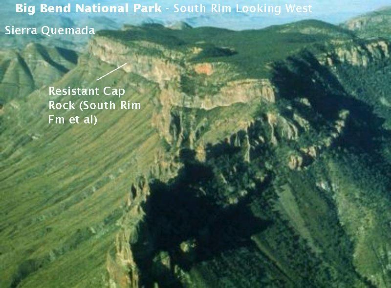
Getting back to the this image, which is an aerial shot of the South Rim, the role of the South Rim Formation as a cap rock is clearly seen. The high Chisos Mountains are an erosional remnant, protected for the moment by the resistant volcanic rock. However, geologically speaking, the Chisos are not long for this world. The greatest threat is the erosion by mass wasting working from around the edges of the South Rim Formation. (Mass wasting in this case results from falls as rock weakened by weathering gives way and plummets down the cliffs.)
The Chisos are a microcosm of sorts of what happens to islands and continents, which are both worn away, not just from on top, but also by ocean waves eating away at the rock mass. No ocean here, of course, but mass wasting performs the same function. As an example, what is now North America was worn away almost to a flat, sea-covered shelf during the Cambrian period due to an absence of mountain-building activity.
FORWARD to the Boot Canyon Trail
BACKWARD to the South Rim Trail - Basin
ALL THE WAY BACK to the Contents