No Phone Home: Telephone Canyon II
Other than the fact there are neither telephones, telephone poles, telephone wires, nor phone reception of any kind, Telephone Canyon is well-named. I understand there was once some sort of government project, during World War I apparently, to string telephone wire through the canyon. Exactly what the purpose of that might have been is hard to fathom, but, considering its difficulty, surely it must have been a major part of the effort to win the war in Europe. Sadly, though, no telephone system was ever installed in the canyon, and to this day you can't phone home from there except by satellite. Nevertheless, the name "Telephone Canyon" was coined and has stuck. And, amazingly, in spite of the failure of this critical project, the war was won anyway.
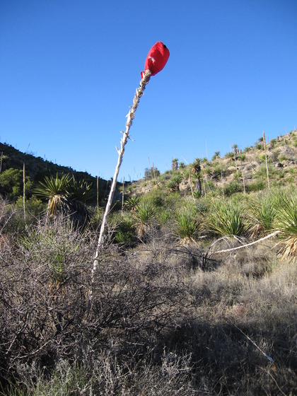
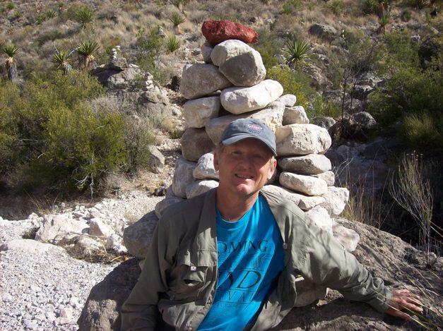
We camped in the uppermost regions of the canyon. Suitable camping sites are pretty hard to find – no surprise there for such a remote area. So we were elated to find a bare spot large enough to pitch a tent. Such a spot is easy to lose in the expanse of the desert, so my brother formulated a brilliant answer to the question of how to relocate it after our hike down the canyon. His sotol-ution to this problem is pictured in the introductory image above. (For more on sotol, click: sotol.)
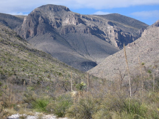
This is what you see as you descend through the upper reaches of Telephone Canyon – extremely rugged terrain resulting from the erosion of the resistant limestone of the lower Cretaceous Santa Elena Formation. At this point you are at around 4000 feet near the summit of a tilted fault block as explained in Telephone Canyon I. You are following the erosional pattern created by the Heath Creek drainage system.
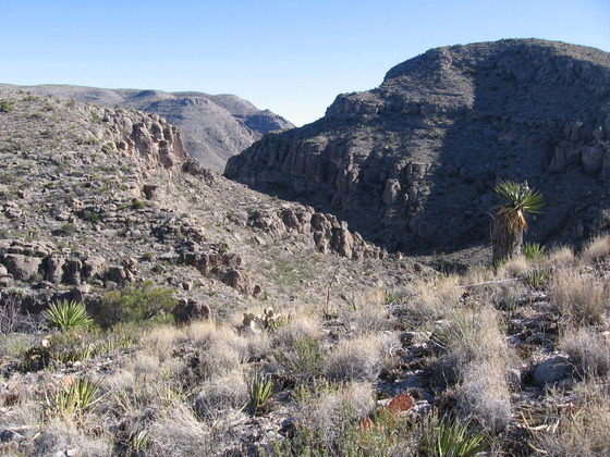
The Heath Creek drainage system has cut from west to east through the northwest-southeast-trending fault-block mountain ranges, forming Telephone Canyon. This implies the drainage preceded the tectonic activity that created these mountains. As the mountains rose, the easterly flowing creek just continued to cut down into the rock as it was lifted up. As you make your way down the canyon, you can see the stratigraphic relationships in this area. The following photograph shows the resistant Santa Elena Limestone forming ridges at the top of the slopes. Debris from the ridges covers lower parts of the Santa Elena and the Sue Peaks Formation, which lies below the Santa Elena. The Sue Peaks Formation is more easily eroded and tends to form slopes rather than ridges.
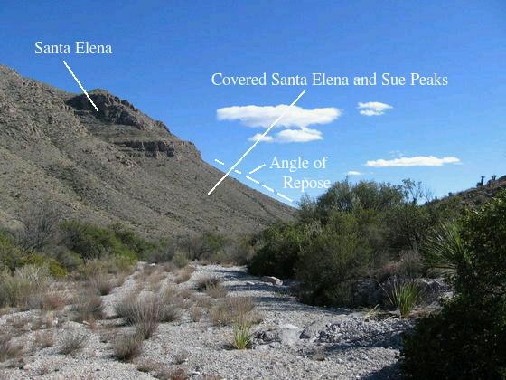
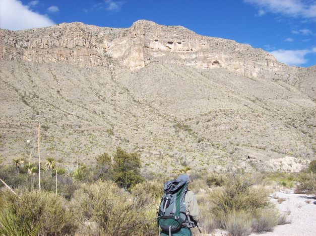
In the following image, my brother trudges down the Heath Creek drainage with a typical Telephone Canyon scene in the background. You can see the cave-like erosional patterns in the Santa Elena. Below that, the Santa Elena Limestone and the Sue Peaks Formation are covered by erosional rock debris called talus. Looking back at the image above, you can see the angle of repose, which is the steepest angle at which loose material can be piled. When more talus is added to the slope by rock falls, the slope eventually is over-steepened and the material slides to re-establish this angle. A typical angle of repose on talus slopes is about the same as the one in the photo above, around 30°. (In physics we call this re-establishment process "self-organized criticality". And, for you physics weenies out there, a slope of 30° corresponds to an effective static coefficient of friction of about 0.6. For you non-physics weenies this means a talus block, on average, will slide if the downslope force on the block due to its weight is 60% of the force pressing the block to the slope.)
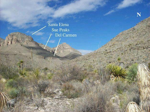
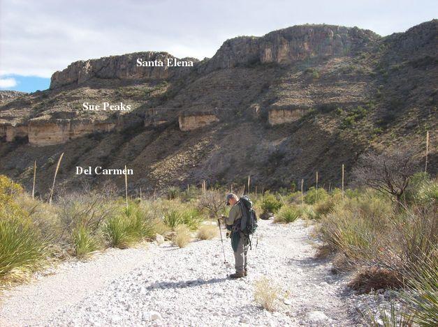
You follow a tributary of Heath Creek down the canyon. About two-thirds of the way to the Strawhouse Trail head, you come upon the confluence of this tributary with Heath Creek, which flows from the north out of a dramatic valley formed by another one of these nearly vertical, north-south-trending faults that are responsible for the fault-block-mountain terrain you are hiking through. The first image below is of the west side of this valley as seen from the canyon, looking northward. The second image is of the east side.
The west side is uplifted with respect to the east side. In the picture below you can see the identification of the Santa Elena Limestone, the Sue Peaks Formation, and the Del Carmen Limestone. The Sue Peaks is a unit of relatively easily eroded limey sediment, whereas the Del Carmen is resistant, forming ridges like the Santa Elena. The topography continues to rise in elevation to the northwest on the west side of the valley, with the highest points being the twin Sue Peaks, 5845 and 5854 feet, about four miles away.
I was puzzled concerning the east side of Heath Creek Canyon. The geologic map published by Ross A. Maxwell and included in his book, The Big Bend of the Rio Grande shows the east side of the canyon to be all Santa Elena, whereas in the picture below I thought I was able to confidently identify both the Sue Peaks Formation and the Del Carmen Limestone on the east side of the canyon. From the topographic maps, it appeared the cliffs are about 600 feet lower on the east compared to the west, implying something like a 600-foot vertical offset along the fault. However, if Maxwell was correct, and the rocks on the east side are all Santa Elena, this would mean something more like a 1200-foot vertical offset.
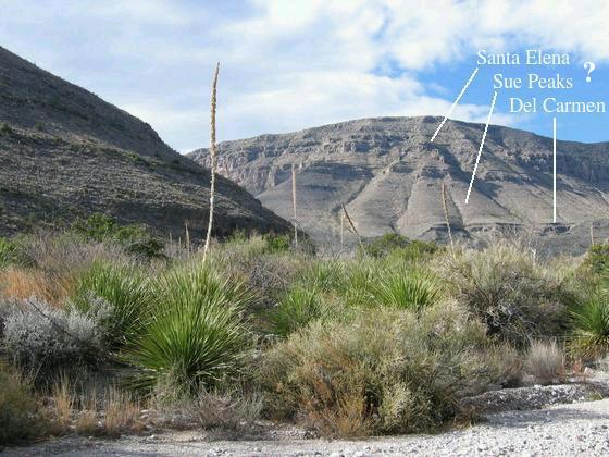
The new geologic map of Big Bend by the USGS (Scientific Investigations Map 3142) continues to show the east side of Heath Creek Canyon to be all Santa Elena. I was motivated to take a close look at the satellite images on Google Earth, and after examining the images, I'm satisfied that the east side of Heath Creek Canyon is indeed Santa Elena. Looking further north up the canyon, it appears that the slope in the picture above is not typical, as there is more cliff topography on the east side of the valley farther to the north, which would be consistent with the more resistant nature of the Santa Elena Formation. Additionally, the offset between the rocks on the west and east side of the canyon discussed above depends on the cliffs referred to being correlated. That is, the rocks they are composed of must have been continuous before separated by erosion. That assumption appears to be in error, and the offset across the canyon may indeed be on the order of a thousand feet or more.
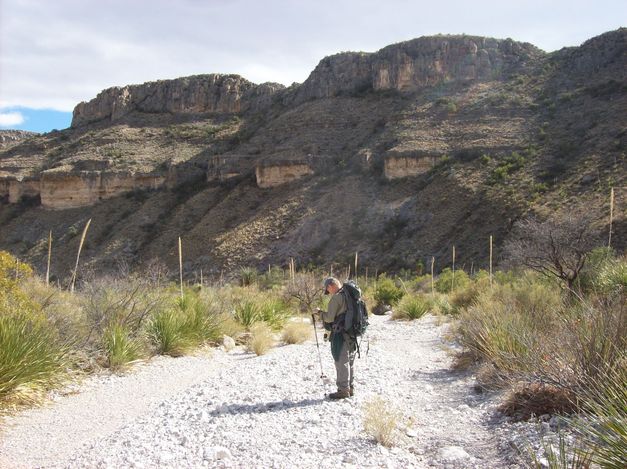
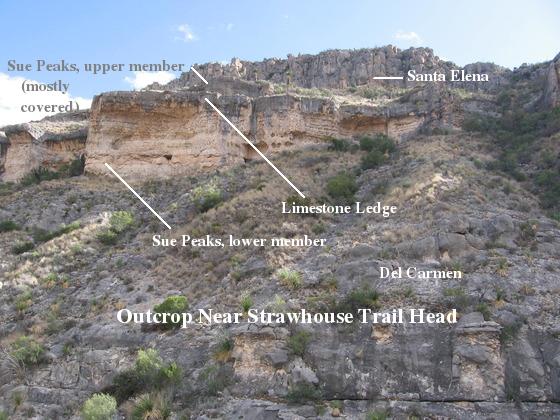
Below, brother Randy is consulting his GPS as we approach the juncture with the Strawhouse Trail and the Sierra del Caballo Muerto (Dead Horse Mountains). The creek bed consists of limestone debris. At first, I thought the yellow outcrops in the distance were the yellowish marl of the Sue Peaks formation, following the map of Ross Maxwell. However, the stratigraphic relationships didn't seem to work out. After returning from the park and looking over the pictures, it seemed to work better to consider the yellow outcrops to be the Telephone Canyon Formation, which is of a similar lithology to Sue Peaks and the cliffs above to be the Del Carmen Limestone. This view was based, however, on believing the slopes on the east side of Heath Creek Canyon sported the Sue Peaks and the Del Carmen below the Santa Elena.
This is a closeup of what was indicated to be an outcrop of Sue Peaks Formation on Maxwell's map. Note the cavities, indicating erosion of a unit containing lime. I began to wonder if this might really be the Telephone Canyon Formation. If this were true, the outcrop above it would be the Del Carmen Limestone and that below the Glen Rose Formation. The problem for me with the idea that this was the Sue Peaks Formation had to do with my supposition of the presence of the Sue Peaks on the east side of Heath Creek Canyon, coupled with the fact that the sedimentary beds in this area generally dip westward. Therefore as you walk eastward in Telephone Canyon you should see older and older rocks. If the Sue Peaks is exposed on the slopes to the west, you should see older rocks exposed farther east, where these photos were taken. If the yellow outcrops were Sue Peaks, you would think there would have to be some structure, such as folding or faulting, to account for these younger rocks being exposed here. Yet, we saw no evidence of such structure, nor is there any on Maxwell's map, which is all I had at the time.
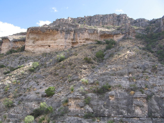
However, it seems to be clear that east side of Heath Creek Canyon is indeed all Santa Elena, and therefore there is no problem with identifying the yellow outcrops pictured above as belonging to the Sue Peaks formation. Well, except for this. As far as I know, the latest and greatest mapping that focused on this area was by A. R. Moustafa, whose work was published in Geologic Quadrangle Map No. 54: Structural Geology of Sierra del Carmen, Trans-Pecos Texas, Bureau of Economic Geology, UT Austin, 1988. This map shows the Sue Peaks Formation outcropping on the north side of Telephone Canyon east of Heath Creek Canyon with the Del Carmen Limestone appearing across the canyon floor on the south beneath the Sue Peaks. The new USGS map and Maxwell show Santa Elena on both sides of the canyon as you proceed east from Heath Creek Canyon, changing to the Sue Peaks Formation on both sides as you continue east. The Sue Peaks shows up first on the north side of Telephone Canyon, then on the south side farther along, but the Del Carmen Limestone of Moustafa is absent on these maps in this area of the canyon.
The outcrop in the picture above seems to support Moustafa, with the Del Carmen present below the Sue Peaks. Otherwise, the differences between the maps are minor. Sorting this all out, the yellowish rocks appear to be the lower marly shale member of the Sue Peaks Formation with a gray limestone member above. In addition, Moustafa wrote that the lower member was topped by a limestone ledge. That appears to be the case in the picture as well, although the "ledge" in the picture may be just the lower bed, as the ledge is supposed to be much thicker than what is shown. Alternatively, it could be that the ledge is not as thick here as elsewhere. So, check out my revised (from an earlier incarnation of this field trip) interpretation of this outcrop in the images below.
On to another paradox. The next photo is that of my brother, Randy, at the Strawhouse Trail head. The geological puzzle here is the origin of the red rock at the top of the cairn. There are no red-rock outcrops in the entire canyon, so the origin of this one rock is a mystery ;-).
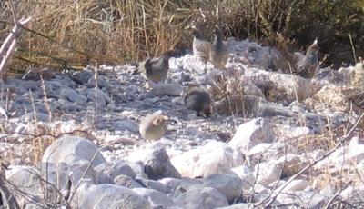
Wildlife was not abundant, to say the least. For one thing the day was very windy with gusts reaching close to 40 mph. Nevertheless, we did come across a small covey of quail.
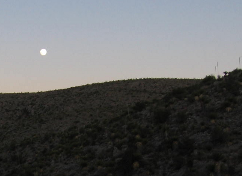
We also met a couple of fellows who had hiked with knapsacks from the Telephone Canyon Trail head and aimed to make it all the way down the Strawhouse Trail that evening. It was already mid-afternoon by the time they turned south down that trail, and they still had twelve miles to go as the crow flies. We hope they made it. At least there was a full moon. If you are young and strong, you might be able to cover ground at three mph on a trail of low to moderate difficulty, which meant it took them at least four more hours to make it to Boquillas. Six or seven would be more realistic, considering they would be hiking in the dark much of the time. Realizing how short daylight was this time of year, we decided to forego hiking farther down the canyon through the Sierra del Caballo Muerto and turn back. This was disappointing, but we needed to get settled before dark.
On the trail back to camp, you get a dramatic view of the southern-most mountain on the west side of Heath Creek Valley. Below is a telephoto. Note the stratigraphic sequence from Santa Elena on top, to Sue Peaks, to a prominent ridge of Del Carmen toward the bottom.
We got back to camp in time to cook some dinner in the waning light and break out the rum and tequila; for, after all, this was New Year's Eve. And what an evening it was with a full blue moon (using the "second full moon of the month" definition of a blue moon) and magnificent isolation. It was also damned cold, but we raised our spirits by raising our spirits, sitting on a downed Spanish dagger that served as a nice couch. Quite a New Year's to remember.
BACKWARD to Telephone Canyon I
FORWARD to Telephone Canyon III
ALL THE WAY BACK to the Contents