
Views from the East: Telephone Canyon III
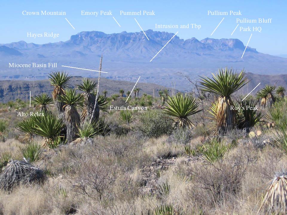
New Year's Day, 2010, and brother Randy and I are making our way back from Telephone Canyon. If the following picture was not taken from the high point on the trail, it is close. In the distance to the west-southwest you can see the eastern-most Chisos Mountains, capped with the South Rim Formation of resistant volcanic rocks. The earliest rocks of this formation belong to the 32 million-year-old Pine Canyon rhyolite, a volcanic rock high in silica. This type of rock is typically erupted explosively, and, indeed, the Pine Canyon rhyolite consists of deposits of rhyolitic tuff created by the violent eruption of hot volcanic ash. Above the Pine Canyon Rhyolite is the Boot Rock member of the South Rim Formation, which includes a variety of volcanic rock types, and above that the Emory Peak rhyolite. These units combine to constitute much of the South Rim Formation, are all about 32 million years old, and all originated from and around the Pine Canyon Caldera, which was centered just to the southwest of Pummel Peak in Pine Canyon (photo below).
A caldera is a crater-like feature formed by the collapse of a volcano as its magma chamber is depleted. Such collapse results in a violent eruption. Much of the magma can be depleted through ring-shaped fissures surrounding the volcano. The remnants of these fissures often form ring dikes, walls of igneous rock, and other linear igneous intrusions that stand above the surrounding terrain due to their resistance to erosion. Hayes Ridge is one of these intrusions. Emory Peak, the highest point in the Chisos at 7825 feet and topped with (what else) Emory Peak rhyolite, is indicated in the picture.
Also visible in the picture are Alto Relex, an upward-faulted block of rock called a horst, topped with Cretaceous Santa Elena Limestone, and Roys Peak (3945 feet), part of an igneous intrusion, a body of magma that cooled underground. It is now exposed by erosion and extends to the north, forming, among other things, the McKinney Hills, through which we were to drive the next day. The slightly orange-tinged deposits of Miocene age labeled as "Miocene Basin Fill" have filled the Tornillo graben, a down-faulted block, which over the past 20 million years formed the low area between Alto Relex and the Chisos. Like Alto Relex, this feature was a result of the Basin and Range tensional faulting that took place over much of the interior western US and Mexico. The Miocene basin-fill deposits are water-deposited sediments ranging from boulder, gravel, and sand, to clay. These have been eroded by a drainage emptying into Tornillo Creek creating Estufa Canyon. Just beyond the western edge of the graben you can see what I think is an intrusive igneous sill, which appears to be protecting the underlying Tertiary Black Peak Formation (Tbp in the picture). (A sill is a sheet-like igneous intrusion that typically moves between and separates pre-existing stratigraphic units.) This formation consists of lithified (turned into rock) mud and sand with some fresh-water limestone. The interesting thing about it is that it spans the time between the dinosaurs and "age of mammals". Both terrestrial and marine, dinosaur and mammal, fossils are found in this formation. Finally, notice the linear feature in the vicinity of the Park headquarters (Panther Junction). This also appears to be a sill, but probably not correlative to the one above as the Black Peak is not found under it. A picture of it follows the one below.
The Chisos Mountains are surrounded by erosional debris forming a sort of apron. I've called this a pediment in the past, but now I'm thinking it is not a true pediment, at least not in a lot of places. As you drive toward the Chisos, you gradually ascend up a slope of debris deposited by water, and this debris may be too thick for the slope to be a pediment. The following image is a view of the north side of the Chisos. You can see a profile of what I used to call pediment, but maybe not. The saddle-like shape of Roys Peak can now be clearly seen.
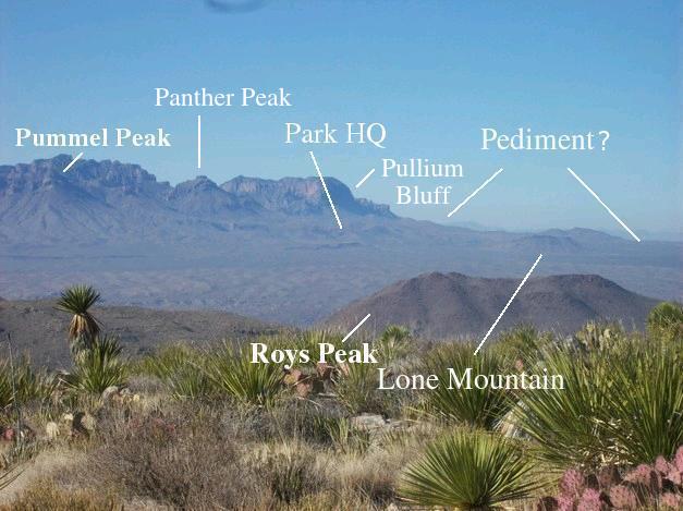
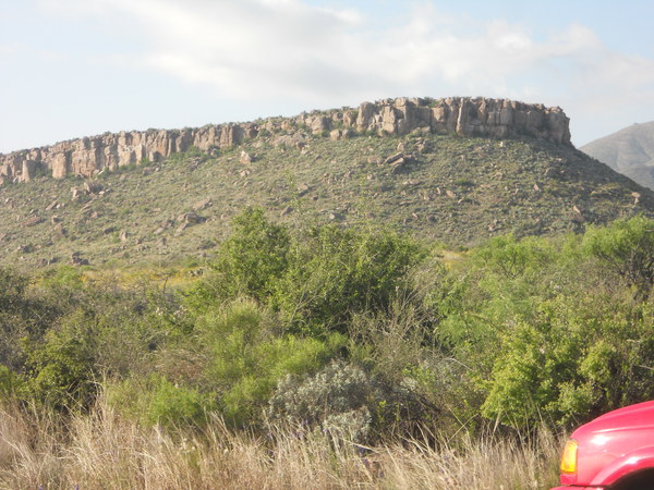
Lone Mountain, not far from park headquarters at Panther Junction, is topped by an igneous sill (dark line of rock at the top), which protects the upper Cretaceous Javelina and Aguja formations beneath from erosion. These rocks mark the change of the Big Bend environment from marine to terrestrial. The igneous rock that forms this sill is 32 million years old and has a composition similar to that of the Pine Canyon rhyolite and the Boot Rock volcanics, and thus, according to the new geologic work done in Big Bend (on which much of the material in these field trips now relies), USGS Scientific Investigations Map 3142, is likely related to the same magmatic source that fed the Pine Canyon Caldera. Although the intrusion that formed Roys Peak is also about 32 million years old, it was a separate event.
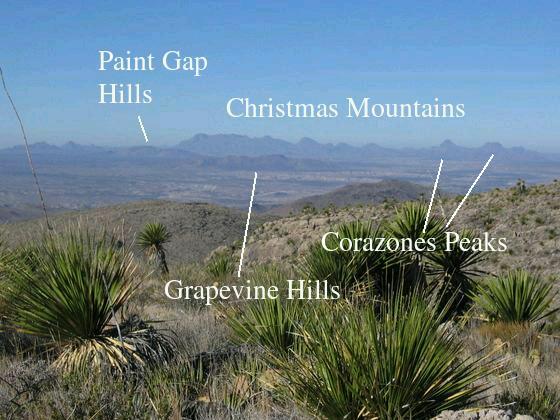
The next picture looks to the west-northwest toward the Christmas Mountains in the distance. To the right are the Corazones Peaks. Also in view are the Grapevine and Paint Gap Hills. Beyond these and to the left are Croton Peak and Slickrock Mountain. All of these, like the rocks of the Pine Canyon Caldera, are due to igneous activity in the middle Oligocene. The Christmas Mountains were a center of volcanic eruptions at that time. The Corazones Peaks and the Grapevine Hills are discordant igneous intrusions (intrusions that push through pre-existing geologic structure), whereas the Paint Gap Hills and Croton Peak are topographically high points in an exposed igneous sill (which is a concordant intrusion as it follows pre-existing structure). Between the mountainous terrain in the foreground and the Grapevine Hills is the Tornillo Creek drainage.
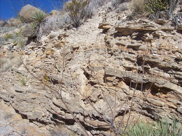
Wandering a bit off the trail, you can find some nice outcrops of the Cretaceous Del Rio clay in drainages between mountain ridges. Here is one example, where the Del Rio has been deformed somewhat. Shaley rocks, like the Del Rio, are more easily deformed than many other types of sedimentary rocks, such as limestone and sandstone. However, the geologist is always confronted with the dilemma of whether the deformation took place before or after the sediment was turned into rock. If the latter, the deformation would be due to tectonic forces; that is, forces originating inside the Earth. If the deformation occurred shortly after deposition, it would likely be due to movement near the surface due to a heavy overload of sediment and/or downslope movement (slumping). The Del Rio clay lies conformably on top of the Santa Elena limestone, meaning there was a (geologically) sudden change in deposition. Some source of terrestrial material (clay in this case) was supplying sediment to the region. The fact the sediment is clay, which consists of very fine particles – clay minerals – shows that the water in which the deposition occurred was rather still. I've seen deposits of lake sediment similar to this (but with finer bedding), but the Del Rio contains marine fossils, so this was not once a lake. Possibly sea level fell or (more likely) the land rose, leading to this change. This was a time when the western margin of the North American continent was tectonically active due to a collision between the continental margin and the Farallon tectonic plate.
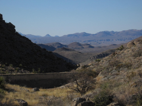
Back at the dam mentioned in Telephone Canyon I, you can look across the Tornillo Creek drainage toward the southern edge of the Rosillos Mountains, which are an intrusion of syenite, a rather quartz-poor granite-like rock. In the distance are the Corazones Peaks.
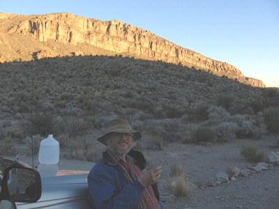
Finally back to our camp and the 4WD Tacoma that has got us over all sorts of road conditions. Alto Relex and a cliff of Santa Elena limestone are alit in the setting sun.
Alas, my Tacoma is no more. For some reason a tire came completely apart as my son was driving it. More unfortunately, he just happened to be taking an exit and ran into the highway divider. Thank goodness for collapsable dividers and air bags. I'm sure Jesse would have been killed otherwise. As it was, he had some injuries which were minor enough that he was out of the hospital in a couple of days. I was only able to afford an old 2001 4WD Ford Ranger as a replacement, but so far it has "done good".
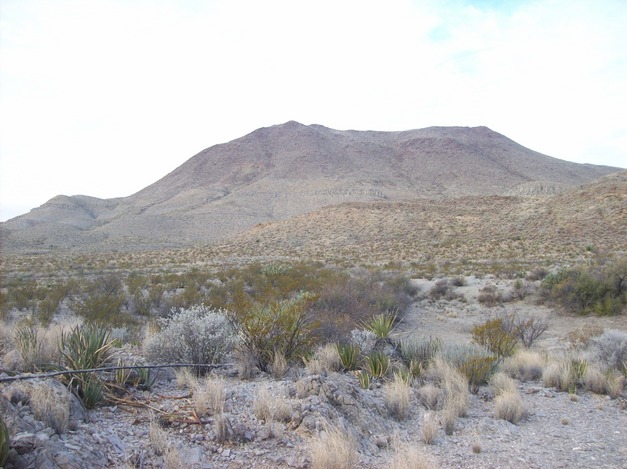
Next morning we get a good look at Roys Peak, which was obscured by fog the day we arrived. This peak is the high topographic feature of an igneous intrusion (mentioned earlier) that extends from south of the Banta Shut-in, north to the McKinney Hills.
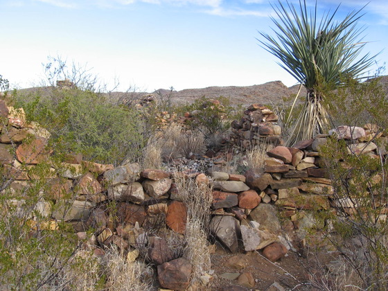
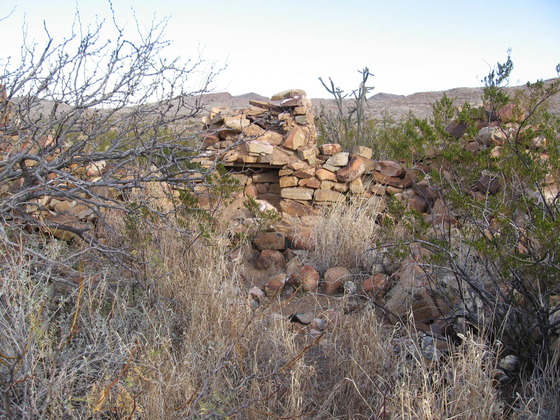
Driving up the Old Ore Road from our vehicle campsite, we came across the ruins of what appears to be an old way station along the Old Ore Road. The second picture below is the remains of the fireplace at that station.
Finally, making our way through the McKinney Hills, here is what appears to be a unit of the upper Cretaceous Boquillas formation resting on the same intrusion seen at Roys Peak. The Boquillas seems to have been intruded in much of the park by igneous rocks. Could it be that all these intrusions, from Mesa de Anguila to this eastern part of the park are related?
BACKWARD to Telephone Canyon II
FORWARD to the Banta Shut-in
ALL THE WAY BACK to the Contents