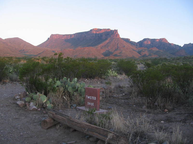
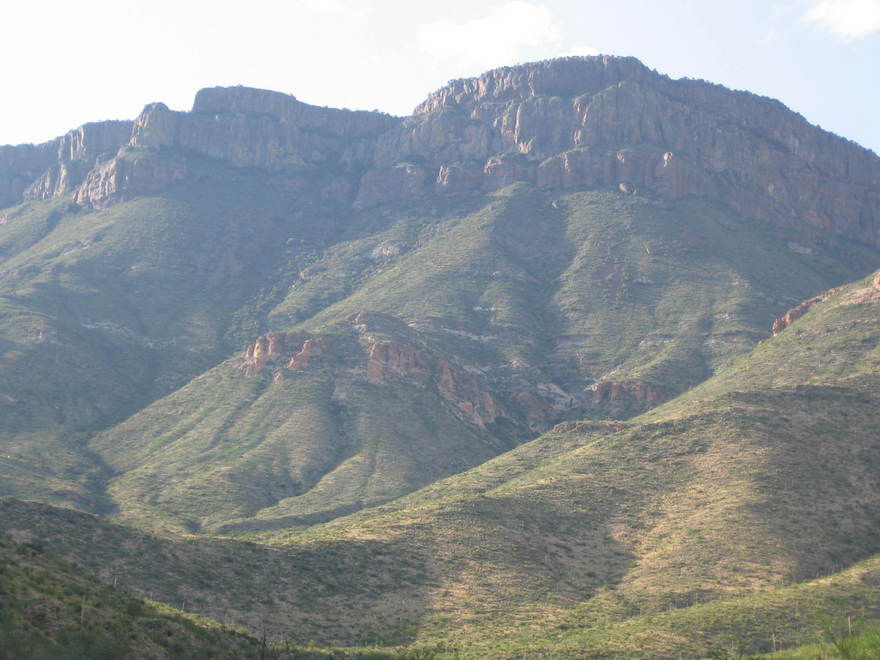
This field trip begins at the Twisted Shoe campsite along the usually dry Juniper Creek. A clear evening makes for a fabulous view of the Sierra del Carmen, Lower Cretaceous limestone cliffs to the southeast of the campsite, beyond the Rio Grande in Mexico. The two most prominent cliffs are composed of the Santa Elena Limestone (upper) and the Del Carmen Limestone (lower) (or whatever these units are called in Mexico). The slopes between these cliffs are due to more easily eroded units. The Sue Peaks Formation of shale, marl, and limestone lies above the Del Carmen and below the Santa Elena. The limestone and marl Telephone Canyon Formation lies below the Del Carmen. These are the same units exposed at a lower elevation along the Rio Grande on Sierra Ponce in Mexico and Mesa de Anguila in Texas at the western side of the park. Below these units, forming a sort of stair-step of alternating limestone and marl, is apparently the Glen Rose Formation at the base of the Cretaceous, or whatever its equivalent is in Mexico. The high point in the Santa Elena is Pico Cerda, "bristle peak" in Spanish.
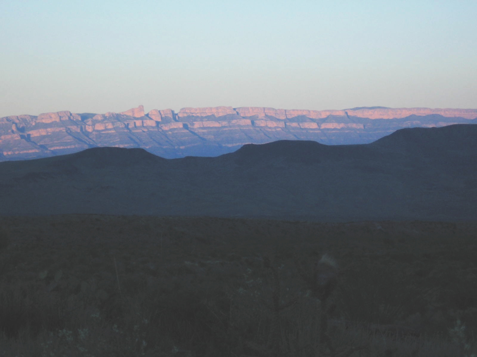
Limestone largely consists of calcite, a mineral (calcium carbonate) that fizzes when in contact with acid, much like Tums. (In fact, that's what Tums is.) Marl is a sort of dirty limestone, and shale is basically mud layers turned into stone. The Sierra del Carmen are relatively high due to a major fault that lies along the eastern side of the park. They were uplifted along the east side of the fault with respect to the rocks to the west (where we are). All these rocks were originally deposited in shallow seas, where the limestones formed in the absence of significant sediment (from shells and tests of organisms as well as direct precipitation of calcite), and the shales and marls formed when sediment was more abundant. These are clues as to how deep the sea was and how far it was from land when these units were deposited.
The major faulting episode that uplifted the Sierra del Carmen had to occur after these rocks were deposited (a geological principle called "the principle of cross-cutting relations"). Since these are Lower Cretaceous rocks (140 to 100 million years old), the faulting had to occur later than that. Other evidence indicates the faulting was due to the extension of the crust in western North America that formed the Basin and Range Province. This was relatively recent, within the past 25 million years. The faulting associated with this activity reactivated the Sierra del Carmen monoclinal fold formed during the Laramide orogeny, a mountain-building episode of the Late Cretaceous to Early Tertiary (around 70 to 50 million years ago), which resulted from the subduction of the Farallon Plate beneath western North America.
My brother, Randy, got up early and took this picture of the South Rim of the High Chisos Mountains in the morning light. The South Rim is over 3000 feet above the Twisted Shoe campsite. Toll Mountain, to the right, is just catching the sun, rising in the northeast over the elevated terrain of Lost Mine Peak, Crown Mountain, and Hayes Ridge off the right side of the image. The rocks of both Toll Mountain and the South Rim are volcanic in origin.
Being the lazier of the two of us, I got up somewhat later and snapped this picture looking north up Juniper Canyon. You see the South Rim and Toll Mountain again, and, at the head of the canyon, Casa Grande Peak, which looks quite different from this perspective than it does in the Basin.
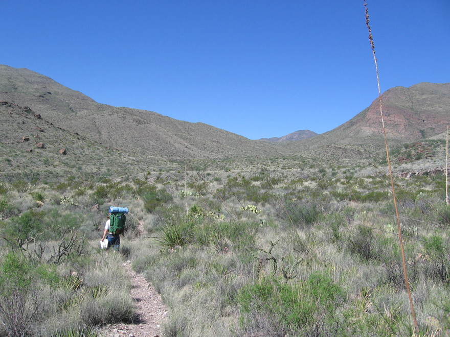
The Dodson trail heads west from a trailhead north of Twisted Shoe, winding between an igneous intrusion on the north and a mountain consisting of a mixture of Eocene aged Chisos Formation rocks of sandstone, tuff, and rhyolite, according to the recently published USGS map, Scientific Investigations Map 3142. (In fact, I am now in the process of revising this field trip with this map in hand. There was much less information readily available before this. This is resulting not only in new material but also in revised and discarded old material – inaccurate or even wrong. Actually, I had already made some revision, but more needed to be done.)
Igneous intrusions, which are found all over the park, were originally masses of magma that moved up into rock already there ("country rock" - not a music genre in this case) and cooled. At that time they were deep underground and have subsequently been uplifted by subterranean forces and exposed by erosion. The intrusions being more resistant to erosion than surrounding rock now form topographic highs. Tuff is volcanic ash, sometimes poorly consolidated and friable and sometimes fused by heat into hard rock ("welded tuff"). Rhyolite is a volcanic rock high in silica and low in iron and is compositionally equivalent to granite, containing minerals such as feldspar, quartz, and biotite mica.
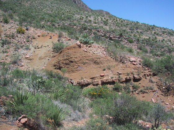
The intrusion to the north, the shoulder of which you can see on the right in the above photo, is of rhyolitic composition according to the USGS map. No radiometic date appears to be available for this intrusion, but similar rock on Tortuga Mountain to the south dates to 28.1 million years. No dates either for the Chisos rocks on the mountain to the right, but the Chisos Formation in general was deposited over an extended period of time (tens of millions of years) in the Eocene and Oligocene epochs. The material you stand on at this point is siltstone belonging to the Chisos Formation according to the USGS map, but there are precious few outcrops to attest to that. For example, here is an outcrop of sorts where you have what appears to be a layer of welded tuff lying in some rather unconsolidated material. Possibly the material is siltstone, but I didn't stop to check it out (not having the USGS map anyway).
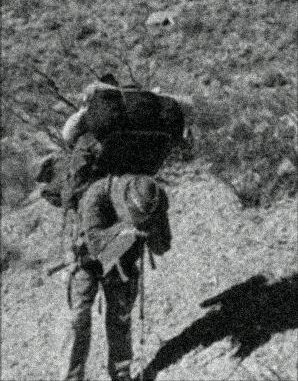
1We were a little apprehensive upon heading out. We had heard that the trail was poorly marked and maintained. Also it was August and extremely hot. The showers of the West Texas "monsoon" season had vanished the past few days, and, even though you don't expect to get much rain on the desert floor, the cloud cover would have been very welcome. (Days later, we were drenched on the South Rim while watching thunderstorm after thunderstorm cross the desert toward the Chisos Mountains from Mexico - right across where we had sweltered days before. Now, however, we were wet and cold. Not even Big Bend is immune to Murphy's law!)
The park rangers couldn't give us any information about the availability of water along the route, although we had hopes of finding water at Fresno Creek, our first day destination. But, to be on the safe side, we loaded ourselves down like beasts of burden with enough water to get us to Blue Creek Ranch, the other end of the trail. Now, neither my brother nor I are what you would call young bucks, and this hike became quite an ordeal with the heavy packs, 100-degree heat, rocky trail, and up-and-down terrain. However, the good thing was that, in spite of the cautions, the trail was easy to follow, and I never had to use my compass and maps to navigate cross-country. Since people have been lost, and even died, on this trail, we suspect the park service has recently done some work on it.
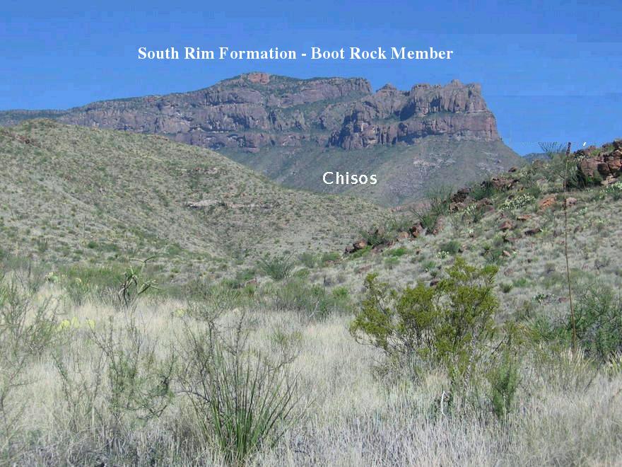
Let's take a closer look at the South Rim. Recently, there has been a revision of how these rocks are interpreted, and the new USGS geological map mentioned previously has drastically changed the geological landscape from what I originally learned. Gone from the South Rim are the Pine Canyon (formerly Brown) Rhyolite, the Wasp Spring Flow Breccia, and the Lost Mine Rhyolite. The rocks that make up the South Rim cliffs are now assigned to the Boot Rock member of the South Rim Formation (age 32.3 million years). The Boot Rock member consists of lava flows, ash flows, and breccia erupted from the Pine Canyon Caldera, the remnants of which are in the Pine Canyon area (where else) in the park (White et al, Petrogenesis and Tectonic Setting of the Peralkaline Pine Canyon Caldera, Trans-Pecos Texas, USA, 2006). The composition of the Boot Rock member volcanic rocks ranges from trachyte to rhyolite. Both trachyte and rhyolite have a very high silica content and are often erupted violently; however, trachyte has a low quartz content and higher alkali metal content compared to rhyolite. The material below the cliffs consists of the Chisos Formation (volcanic and sedimentary rocks, mostly covered in this picture with colluvial debris). Colluvium is just the accumulation of debris below a hill or cliff due to various erosional processes.
The Dodson trail tracks mostly through the Chisos Formation, riddled here and there with igneous intrusions. In spite of the recent USGS map and the field work that went into it, it appears to me the Chisos Formation has still not been mapped in detail and is not well understood. Prior to this effort, a few units of this group had been named and mapped, but most of the sedimentary and volcanic rocks that make up the Chisos Formation have, until recently, at least, been lumped together as unknowns, and this is still true to a fair extent. This is not hard to understand as much of the Chisos Formation is buried under soil and debris, and good outcrops are not common due to the soft nature of most of this rock.
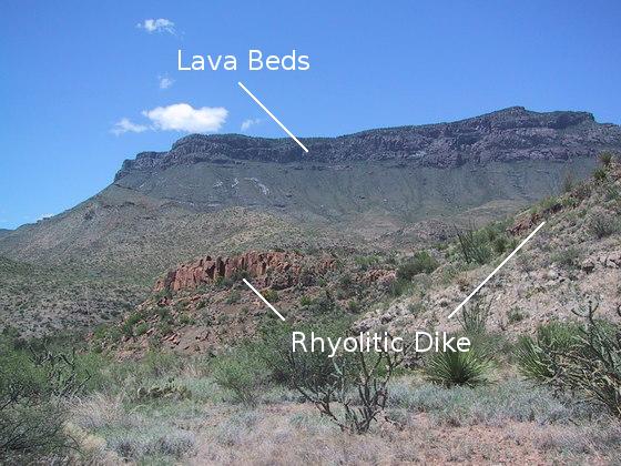
There are some hard-rock outcrops, however. Check out the image below of what appears to be a mesa topped by several dark lava flows (possibly basalt, reflecting the dark color, but more likely rhyolite). Further investigation shows this outcrop rests on top of a flat ridge of the mountain consisting of Chisos Formation rocks mentioned above. The lava flows made such a thick deposit, I initially wondered if it could be the Bee Mountain Basalt, one of the known and mapped units of the Chisos Formation. However, the USGS map only indicates what it labels the "Tcstr" member of the Chisos Formation ("str" for "sandstone, tuff, and rhyolite" as mentioned earlier) in this area, and the description of this member does not mention basalt. The Bee Mountain Basalt is not mapped anywhere close to this point, although there are basaltic rocks to the south, notably on Tortuga Mountain. The reddish-brown rock in the foreground is one of the several rhyolitic dikes found along the Dodson trail (although most aren't clearly visible from the trail itself). Dikes were once sheets of magma cutting across the "country rock" and would feed lava flows were they to breach the surface. This dike does not appear on the USGS map. I couldn't tell it was a dike from the trail, but after consulting Google Earth, I saw it was clearly a dike.
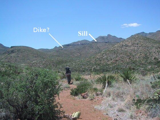
In the following image beyond Randy, toiling under his heavy pack, you see a prominent sill in the Sierra Quemada ("burned mountains"). This is apparently the same sill that can be seen from the South Rim. A sill is an igneous intrusion that typically follows a weakness between two layers of rock, assuming a tabular form. A sill is termed a "concordant" intrusion, because it follows the geologic structure already in place rather than cutting across it (which, not surprisingly, is called "discordant"). According to the USGS map, this is a basaltic sill, like so many others found in the park. Although there is no date for this sill, the basalt on Tortuga Mountain, which may also be a sill, dates to 28.6 million years. This sill was visible for much of the Dodson hike. There is a dike cutting through the sill at the approximate location of the line of rock indicated in the photo, so I believe this is likely that dike. The dike is of rhyolite and is younger than the sill, again due to "cross-cutting relations".
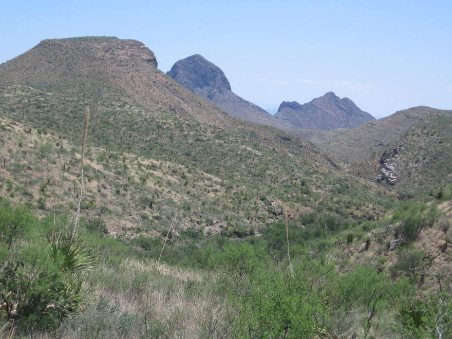
Once you get past the mesa in the second figure above, you have come across a window to the south in the mountainous terrain, courtesy of the drainage in the foreground. What greets you is a fantastic view of two fabled intrusive features of the park, Elephant Tusk and Backbone Ridge. To the left is Tortuga Mountain. Both Elephant Tusk and Backbone Ridge are Tertiary granitic intrusions. Unfortunately, there are no radiometric dates of these two intrusions that I know of. This side of Tortuga Mountain consists of the upper Cretaceous Aguja Formation, in whose sediments you see the transition from sea to land in Big Bend. From this vantage point I could not make out the ring of basalt that surrounds the mountain. There is also an outcrop of intrusive rhyolitic rock on the far side of the mountain 28.1 million years old.
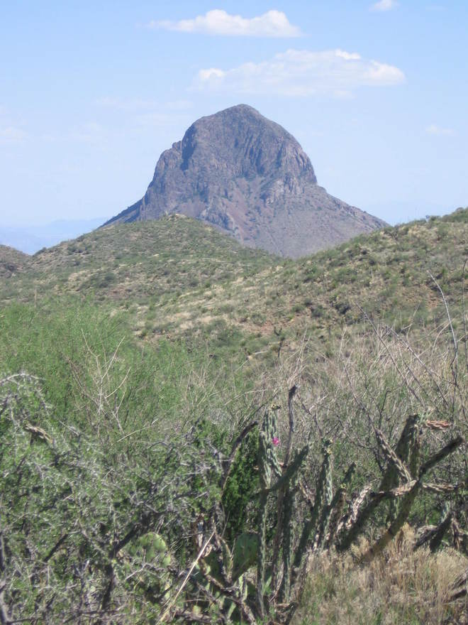
And here is a great picture Randy got of "the Tusk".
Well, there was water in Fresno Creek after all - plenty of water. We felt silly for having lugged so much water across the desert. "Logic would dictate" that with all the monsoon showers occurring over previous weeks, Fresno Creek would have water flowing in its bed. On the other hand, you don't want to be caught in the desert without water.
From our camp at Fresno Creek, the South Rim was pretty awesome in the evening light. (The image below is a telephoto.) According to recent work in this general area (Sedimentation, Volcanism, and Intrusion in the Lower Chisos Group, Big Bend National Park, Texas, by Barker et al), the prominent tannish-orange outcrop below the rim could be a bed of trachyandesite, rhyolite, or welded tuff. I originally took it to be the 30-million-year-old trachyandesite that was previously thought to be the Tule Mountain Trachyandesite. The new USGS map (Scientific Investigations Map 3142) of this area indicates no trachyandesite, just the youngest undivided rocks of the Chisos Formation of Oligocene and Eocene age. If this rock correlates with that along Blue Creek, it consists of welded tuff. There is a lot of whitish material exposed on the slope where the vegetation is thinner, indicating quite a bit of volcanic ash was deposited before the South Rim rocks, which form the high cliffs, were erupted.
FORWARD to Dodson Trail II
BACKWARD to the Window
ALL THE WAY BACK to the Contents