I'll Huff and I'll Puff...: Lower Strawhouse Trail
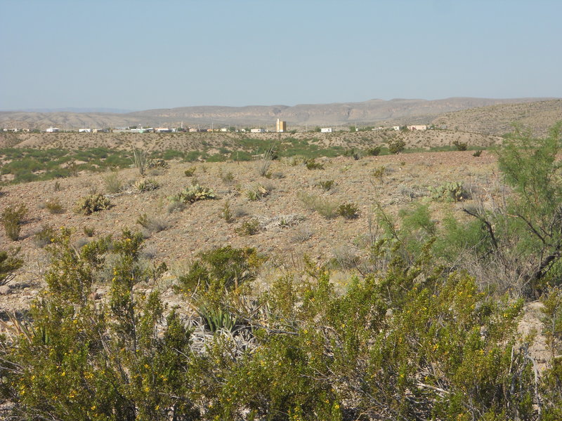
The southern end of the Strawhouse trail begins near the Boquillas Canyon overlook, from which you can get the following view of the town of Boquillas del Carmen, perched on a fluvial fill terrace of the Rio Grande, consisting of water-deposited alluvium, deposited by the river during flood stages when its bed was higher. (Since this feature and others discussed later are in Mexico, I am extrapolating from what was mapped on the U.S. side, but I think what I have here is correct.) Subsequently, the alluvium has been eroded to create terrace isles like this one. For years since the attack of September 11, 2001, fear-mongering politicians and government officials have virtually cut the village off from the outside world by eliminating crossings into the US. Access to needed supplies was extremely difficult through Mexico, a situation I believe continues today. Finally, the US government has established a controlled crossing, a move that has brought foam-flecked outrage from extreme right wingers about floods of illegal aliens spreading like fire ants across Big Bend and has done not much, as far as I can tell, to really help the citizens of Boquillas del Carmen return to the lives they used to know. You have to go through official scrutiny both ways by officials of both governments - not the informal crossing it used to be. At least it's not as bad as the TSA, and maybe a modicum of tourism will help the town get back on its feet.
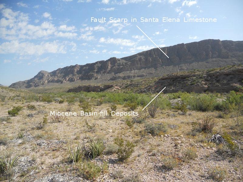
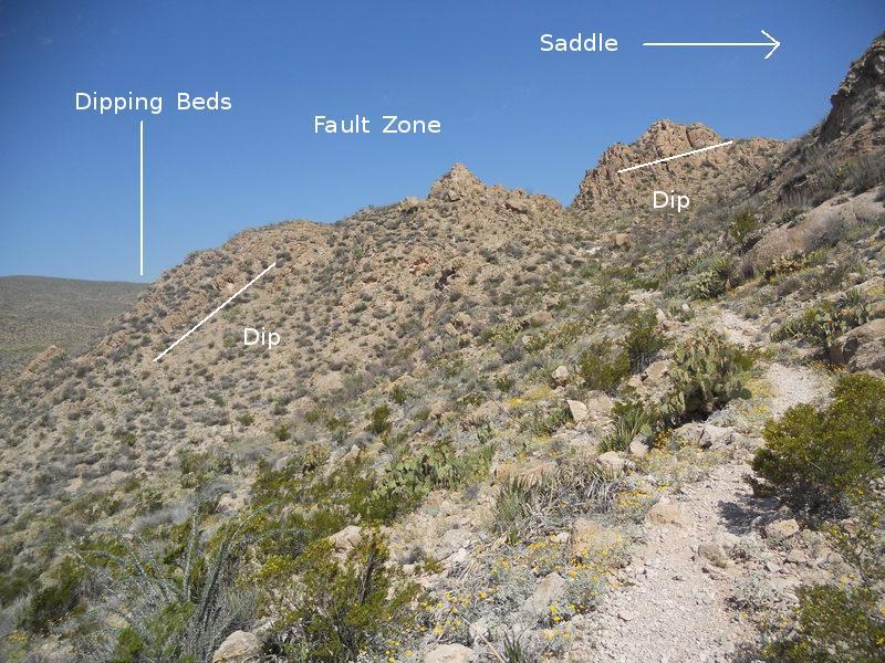
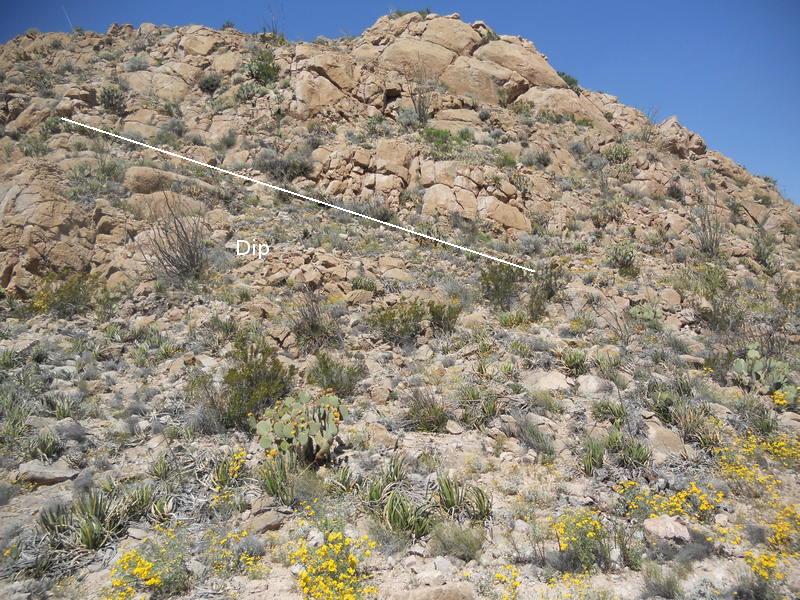
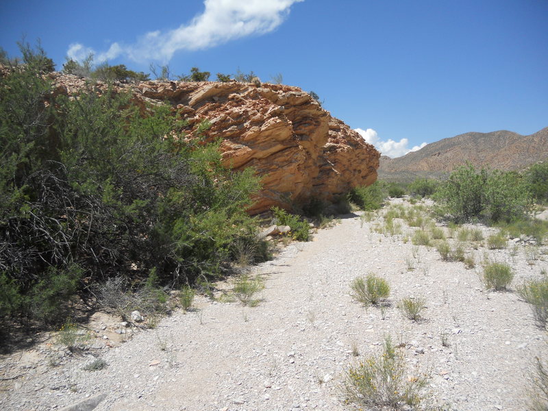
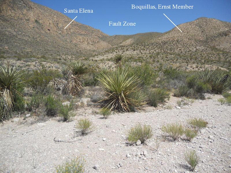
The trailhead is posted as the Marufo Vega Trail but is also the southern end of the Strawhouse trail. Farther to the north the two trails separate, with the Marufo Vega heading east and the Strawhouse continuing north. As you find when hiking to and into Telephone Canyon, the terrain along the trail as you head north is due largely to the faulting associated with the Basin and Range geologic province of the western US, which has produced fault-block mountains on the eastern side of Big Bend National Park. Relative tension in the Earth's crust beginning around 20 million years ago in much of the western US and parts of Mexico led to the crustal extension responsible for this type of mountains. In the image below, taken early in the hike, you see a fault scarp of Basin and Range age, which has uplifted the Santa Elena Limestone of lower Cretaceous age on the far side of the fault, and Miocene deposits that filled in low areas (basins) between fault-block mountains. (The Miocene occurred from 23 to 5 million years ago.) The material you are hiking on (when you are out of the wash) is alluvial, deposited in the middle to late Pleistocene, roughly 2 million to 12 thousand years ago when the climate turned cooler and wetter with every new glacier advance into what is now the US.
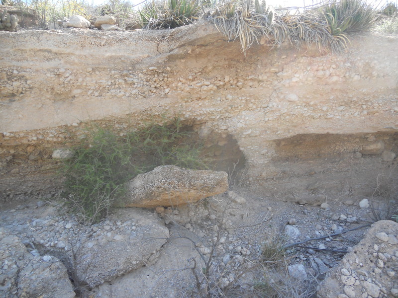
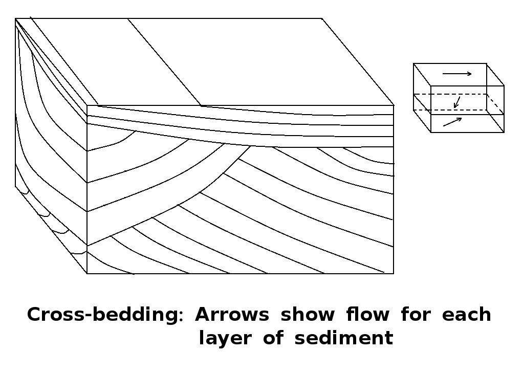
The next picture is a close-up of the Miocene basin-fill deposits. They consist of sand, gravel, and cobbles. Note the cross-bedding and how well-rounded the clasts are. (A clast is a piece of geological detritus, ranging in size from clay to boulder.) This indicates the material was deposited in a stream environment. The figure after that is a diagram of cross-bedding. The basic process consists of deposition, erosion, and more deposition, often with changing current directions and changing erosional slopes on which new deposition occurs. Referring to the arrows of flow direction in the second figure, you can see that the lower bed in the image was deposited by water flowing generally from right to left. (This was well before the advent of the Rio Grande. Now the flow is in the opposite direction.) Also note the caliche layer at the surface, which forms a hard layer protecting the material beneath it from erosion.
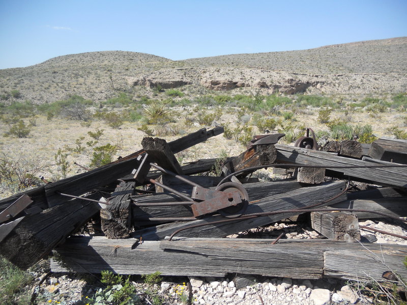
Shortly after the above picture was taken, I came across ruins of the old ore tramway that used to operate here. It carried lead, zinc, and silver ore from the Puerto Rico mine in Mexico four miles to a terminal where mule trains took the ore north to Marathon and the rail line. More on this tramway can be found here. The picture that introduces this virtual field trip is of the ruins I came across. You can right click on the picture to see it enlarged. More of the Miocene basin-fill deposits are visible in the background.
If you're lucky, you will eventually come upon a sign in the wash that marks the split between two legs of the Strawhouse Trail. The left trail goes through a canyon where you have to do a lot of boulder hopping - not a route to take on horseback. The right trail goes up over a small saddle to a point where it splits again - into the continuation of the Strawhouse Trail on the left that descends back into the wash and the Marufo Vega Trail on the right. I met a couple who had missed the sign and were heading the wrong way, into the canyon instead of up through the saddle to the Marufo Vega Trail, which was the trail they wanted. However, they were clearly not prepared for a hike in the desert, so it's just as well they decided to turn back. (The woman was wearing very short shorts, for example. As one person has said, Big Bend is full of vegetables with knives.) The point is, the park service needs to mark the place where the trail divides much more clearly. I didn't see the sign on my way back, though I was looking for it.
I decided to take the right trail to the saddle, which crosses the fault responsible for the fault scarp pictured earlier. The fault is covered with rock debris here, but you can see its effects in the next picture. Note the rocks on the left (Santa Elena Limestone) are steeply dipping left, to the east, whereas those on the right are dipping much less.
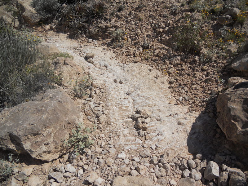
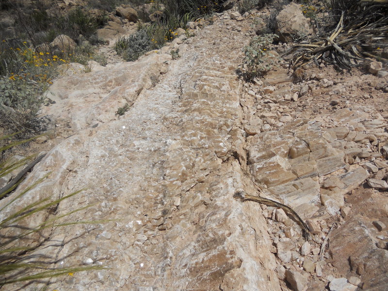
The trail up to the saddle follows a spectacular and large vein of calcite, as depicted in the following two images. It must have stretched for around 100 feet (about 30 meters) along the trail, and some of the crystals displayed are quite large. The Santa Elena, the rock here, is a limestone, which has abundant calcium carbonate ("Tums" ;-) in the form of the mineral calcite. Calcite is relatively easily dissolved in water, especially acidic water, and dissolves more readily when subject to pressure. A likely explanation of the occurence of this vein is that the pressure associated with the faulting produced fractures which water pressure could force open. The water contained dissolved calcium carbonate, which crystallized into calcite. Calcium carbonate, due to its abundance, is responsible for many calcite veins filling cracks under a variety of geological conditions. The fact the crystals in these pictures are perpendicular to the sides of the fracture indicates no lateral movement has occurred along it.
When you cross to the other side of the saddle, you see that the beds are no longer dipping to the west, but rather to the east, as seen below. Note that the rocks are pretty broken up on both sides of the fault.
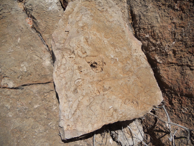
Fossils can be found in detrital rocks along the path. In the following picture you can see mostly clams and/or oysters. The distortions these fossils have undergone in the fault zone is clearly visible in the shape of the gastropod (snail) near the center bottom of the picture. As always, I like to point out that it is illegal - not to mention selfish - to collect samples from a national park. Park rangers have told me that people often attempt to get away with it, however. That's pretty sad.
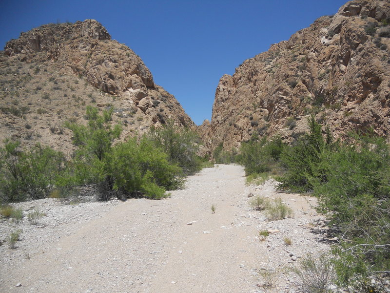
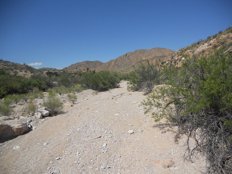
After examining the geology on the saddle, I returned to the wash in order to go through the canyon the saddle trail avoids. The entrance to the canyon is shown below. The fault goes through here, perpendicular to the trend of the canyon, and the rocks certainly appear to have been subject to a lot of trauma.
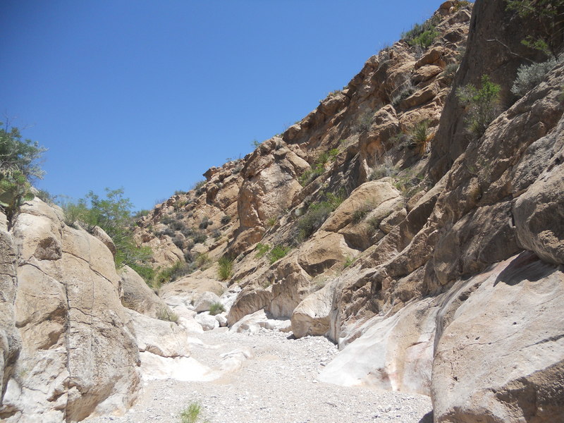
As you make your way north through the canyon you see rocks dipping similar to those on the saddle, that is, in a generally westerly direction. The following picture is looking to the northeast. The degree of the slope here is determined by the dip of the beds. When beds dip parallel to a slope, there is enhanced danger of rock slides, something engineers have to take into account when construction involves slope-forming work. The dipping beds are likely on the western side of the Bend monocline, an extensive monocline in this area of the park. A monocline is a sort of "kink" in the rocks, where rock strata that are horizontal trend into dipping strata then back to horizontal again. Monoclines are, to my knowledge, always (or almost always) evidence of subsurface faults. The "kink" locates the position of the fault, where the rocks of the monocline have been shifted down on one side relative to the other without being fractured. In other words the fault does not extend to the surface. The kink in this monocline is farther to the east.
After exiting the canyon and much scrambling over large boulders, you begin to see the Del Rio Clay, first in the wash and then in outcrops on the side of the wash. The Del Rio Clay rests stratigraphically on the Santa Elena Limestone and is upper Cretaceous in age. It is a shale, that is, rock made of mud that has rock cleavage, which gives it its layered appearance. These layers are typically thin and are due to flaky clay minerals that have been deposited in quiet water such that they are oriented parallel to the bedding. There has to be a source of sediment for shale to be deposited, so evidently there was a change in the depositional environment between the Santa Elena - a limestone deposited in a shallow tropical sea (Texas was in the tropics at this time) - and the Del Rio, probably deposited when the area became a shallow and quiet region of the continental shelf, but with a source of fine sediment from the continent. The picture of the outcrop below was taken looking north.
In the next picture the Del Rio Clay on the right has been eroded by water carrying the sediment of the Miocene basin-fill deposits on the left, creating what is known in geology as an angular unconformity. An unconformity marks a break in deposition in the geologic record. An angular unconformity separates beds dipping at one angle from those dipping at a different angle, and typically indicates a large time gap in the geologic record. That is true here, where the missing record must be on the order of 100 million years.
As you continue up the wash that serves as the Strawhouse Trail, you come across upper Cretaceous rock strata that were deposited later than the Del Rio Clay. In the following photo, the Ernst member of the Boquillas Formation is in the foreground with the Santa Elena Limestone in the distance. Since the Boquillas is younger than the Santa Elena, there is obviously a fault line on the other side of the Boquillas across which the Santa Elena has been raised. Not seen at this location is the Buda Limestone, which lies above the Del Rio and beneath the Boquillas. The Boquillas Formation in general is marked by rather thin beds of rather "dirty" limestone. The Ernst member is very similar to the San Vincente member of that formation (not seen here) that lies above it. Like the Del Rio, it is of late Cretaceous age and was deposited in a marine environment where there was deposition of both calcium carbonate (mostly due to organisms using it for shells) and clay.

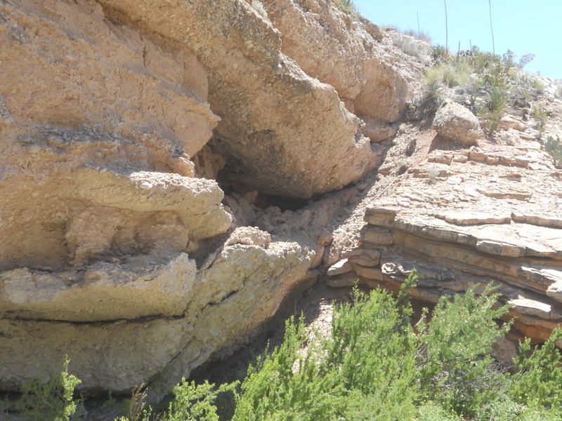
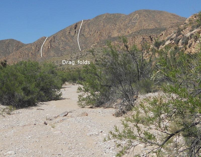
Before too long you approach another unnamed (as far as I know) canyon. This canyon is of geological interest because, as in the case of Dog Canyon, you can hike through the guts of an old thrust fault. The thrust at Dog Canyon is the Santiago Mountains thrust, which is of Laramide age. There were two major thrust-fault episodes in Big Bend. This thrust could not be of the earlier event, the Ouachita orogeny, a mountain building event in the late Paleozoic, because the fault cuts through rocks of Cretaceous age which are much younger. Hence, I'm assuming this thrust occurred during the Laramide mountain-building event. The following picture is what you see when approaching this canyon. You can make out the strongly folded rocks in the sides of the mountain in the distance.
Zooming in for a closer look, you can see how the strata of the Santa Elena Formation were deformed as drag folds by the thrust fault, which in relative terms shoved rock from left to right beneath the deformed beds in this view.
This area contains complex faulting. There are thrust faults, normal faults, and strike-slip faults. I could have spent a lot more time here than I had allotted, and I'd like to return some day. A normal fault is responsible for what you see below. A normal fault is produced by relative tension in the crust, with one side of the fault relatively up compared to the other. A great exposed example of a normal fault is found in Boquillas Canyon. There is no indication of which side is up on the new USGS Scientific Investigations Map 3142, 2011, for this area of the fault, but it certainly looks like the Santa Elena Limestone on the left (northeast) is up compared to the Boquillas Formation on the southwest side of the fault. The weakness of rocks disturbed in the fault zone appears to be responsible for the valley here.
Here you are, inside the canyon with vertical Santa Elena rocks on the east side of the drainage through the canyon. These have been bent up by the thrusting action. The trace of the thrust fault itself runs from near the southern entrance to the canyon to the northeast along the southwest side of the canyon ridge, according to the USGS map. I didn't find the fault trace, which is supposed to be exposed here, as the time allotted for this part of my trip to the park was running out.
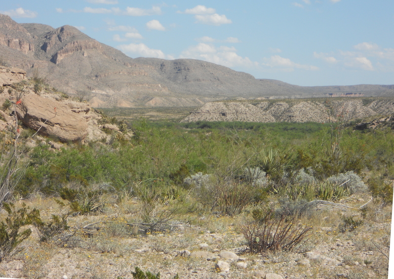
The final picture of the trip. From this vantage point you can see the fill terraces of the Rio Grande, like the one on which the town of Boquillas del Carmen resides. These terraces consist of sediment deposited during the Pleistocene, when at times the climate was wetter than it is today. There is actually a sort of "stair-step" of terraces, with the higher ones being older. (See the Maxwell Scenic Highway trip.) The terraces are former flood plains. As the river continues to erode down into its bed, especially during drier periods when the river is not as wide, the flood plains are exposed to erosion, creating the terraces.
BACKWARD to the Banta Shut-in
FORWARD to Lower Tornillo Creek
ALL THE WAY BACK to the Contents